
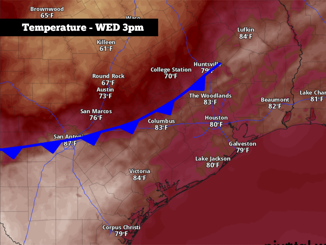
Shown are the potential temps across the region at 3 p.m., as the cold front moves through the region.
Pivotal Weather
After a rather strong cold front swept through San Antonio last weekend, temperatures quickly rebounded this week. Afternoon temps in the Alamo City reached the upper 80s on Tuesday, and similarly hot and humid weather is likely again across South Texas for the first part of Wednesday.

However, more changes are coming, as another cold front is expected to push into San Antonio by Wednesday evening. First, before the front moves all the way through, it might help trigger a few strong to severe thunderstorms across parts of Central and South Texas. Then, it’ll bring a noticeable drop in temperatures tonight and into Thursday. Here’s what you can expect.
Article continues below this ad
Wednesday’s forecast
Warm, cloudy and humid weather is expected early Wednesday, as San Antonio temperatures will likely sit in the mid-70s through 9 a.m. with more than 90% relative humidity also in place. A few isolated raindrops are possible, but most around San Antonio will stay dry throughout the morning.
An isolated strong thunderstorm is also possible during the morning, but mainly in the Hill Country. Cities such as Rocksprings, Kerrville, and Fredericksburg will have a 30% chance of morning thunderstorms.
Shown are the potential heat index values across the region at 3 p.m. Wednesday.
Pivotal Weather
Temperatures will slowly rise during the middle of the day, reaching 80 degrees by 11 a.m. before topping out in the mid- 80s by the early afternoon. Skies will turn partly sunny, and with elevated humidity levels continuing, heat index values or “feels like” temperatures will into the low 90s.
Article continues below this ad
The incoming cold front is expected to move through San Antonio by the mid-afternoon, likely between 1 and 4 p.m. Winds will shift direction and start moving in from the north, and temperatures will start to fall gradually. As the front arrives, a few thunderstorms will become possible.
Overall storm chances in South Texas will be rather low, with only about a 20% chance of storms for the San Antonio metro area. That means that about 20% of the region will likely see rainfall, leaving 80% of the area dry. Storm chances will be slightly higher across the Hill Country.
Shown is the Storm Prediction Center’s outlook for Texas on Wednesday. San Antonio is under a low-end level 1 of 5 risk of isolated severe thunderstorms.
Storm Prediction Center
However, while overall storm chances are low, the storms that do develop could strengthen quickly and become severe. San Antonio is under a level 1 of 5 risk of severe thunderstorms, meaning that a few storms in the area could produce large hail and damaging winds.
Article continues below this ad
Temperatures falling
The cold front will continue to bring cooler air into San Antonio overnight and into early Thursday morning. Temperatures in San Antonio will fall into the mid-60s by Thursday morning, and they’re only expected to rise into the low 70s by the afternoon — about 12 degrees cooler than they were on Wednesday.
Scattered showers and thunderstorms are also possible Thursday afternoon and into the evening. San Antonio’s rain chances will rise to around 30%, with isolated downpours possible. Although a few storms could be strong, severe weather is not expected as the cooler air behind the front will limit the instability in the atmosphere.
Overall rainfall totals will likely be light, as the National Blend of Models suggests that San Antonio will likely see less than a quarter-inch of rain. However, isolated higher amounts are possible.
Article continues below this ad
A few scattered thunderstorms will remain possible from Friday through the weekend, with about a 30% chance of storms possible each day. A few strong to severe storms will be possible over the weekend, too, so stay updated at expressnews.com/weather for daily forecasts.
Temperatures will trend higher over the weekend, as Friday’s temps peak near 80 degrees before transitioning into the low 90s degrees by Sunday afternoon. Weekend nighttime temps will also become warmer again, staying above the upper 60s to lower 70s.