
A wetter and more active stretch of weather returns to Houston Friday as a slow-moving frontal boundary stalls near the region and taps into a deeper surge of atmospheric moisture.
The setup favors repeated rounds of showers and thunderstorms capable of producing locally heavy rainfall and isolated street flooding from late Friday into Saturday morning.
Rainfall totals will vary considerably from one neighborhood to the next, but areas that see multiple storms passing overhead could quickly pick up several inches of rain in a relatively short period.
Bottom line
Locally heavy rainfall could trigger isolated street flooding, especially in low-lying and urban flood-prone areas.
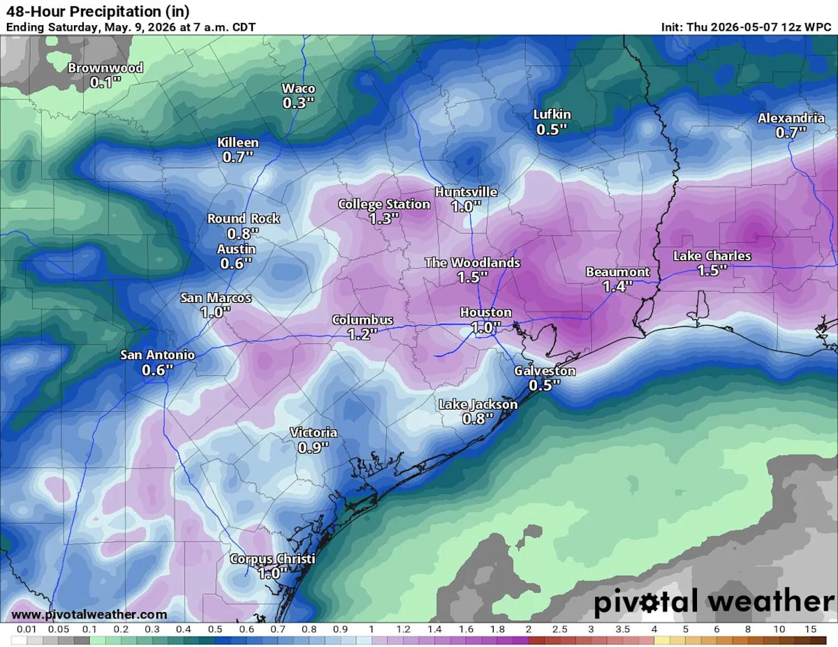
Most of the Houston area should receive an inch to 2 inches of rain through Saturday, although isolated spots could see more than 3 inches where storms repeatedly pass overhead.
Rainfall totals will vary widely from one neighborhood to the next, with some areas seeing much heavier rainfall than others.
More storms could redevelop Saturday, prolonging flooding concerns into the weekend.
Conditions should gradually improve late Sunday into early next week as drier, warmer weather returns to Houston.
Here’s a timeline of when the heaviest rainfall is likely to move in.
Friday morning: Scattered showers as humidity climbs
On the heels of a fairly comfortable Thursday, the same cold front that dropped dew point temperatures into the 50s (indicating less humidity) will begin lifting northward as a warm front Friday.
The day will begin warm and increasingly humid, with scattered showers and isolated thunderstorms developing through the morning. Coverage should remain somewhat limited early in the day, so not everyone will start Friday with rain.
As a deeper volume of moisture out of the Gulf of Mexico returns through midday, the weather will become increasingly favorable for more widespread storm activity to develop.
Friday afternoon/evening: Flooding concerns peak
The highest potential for heavy rainfall and localized flooding appears likely from Friday afternoon through Friday night as storms become more frequent and produce rain more efficiently.
A stalled boundary near the surface combined with increasing moisture aloft will allow thunderstorms to repeatedly redevelop across parts of the Houston area. Atmospheric moisture is expected to climb to levels well above normal for early May, which increases the likelihood of intense rainfall rates in stronger storms.
SPRING RAIN UNCERTAINTY: Houston turned rainy in April, but spring could still swing wildly either way,
Current guidance continues to favor communities closer to the coast for the highest rainfall totals, although confidence remains lower regarding exactly where the heaviest bands of rain clouds will ultimately set up.
Most of the Houston area should receive an inch to 2 inches of rain through Friday, but isolated pockets could exceed 3 inches where storms repeatedly move across the same locations. Given the uneven nature of thunderstorm rainfall, some neighborhoods may see far less.
Drivers should anticipate water pooling on roads, reduced visibility and potentially hazardous travel conditions during heavier downpours Friday evening, especially in low-lying spots and urban flood-prone areas.
Storms prolong flood concerns Saturday
The unsettled pattern is expected to continue into Saturday as the upper-level atmospheric disturbance lingers near the Texas coast.
Another round of scattered thunderstorms could develop during the afternoon and evening hours, once again driven in part by daytime heating and abundant atmospheric moisture. Any storms that develop Saturday will be capable of producing more heavy rainfall, especially places that storms repeatedly soaked Friday. A few strong storms also will be possible, especially north and east of Houston.
Another inch or more of rainfall could fall in parts of the Houston area through Saturday, potentially aggravating flooding concerns where soils become saturated.
Drier, warmer weather returns next week
Forecast guidance continues to indicate improving weather by late Sunday into Monday as the storm system finally shifts east into Louisiana.
Rain chances should gradually decrease heading into early next week, while temperatures trend warmer with afternoon highs returning to the middle to upper 80s across Houston.
Subscribe
There’s more to Houston with the Chronicle. Subscribe today for just 25¢.
This article originally published at Houston weather: Heavy rainfall, flood threats this weekend. Here’s a timeline of impacts..