
FORECAST HIGHLIGHTS
8PM to 2AM: Storms likely, some strong/severe
MAIN THREAT: Damaging gusts, quarter-sized hail
IMPACT: Some power outages & trees snapped
ACTIONS: Have a way to get warnings, secure loose outdoor items, park car in garage or away from trees if possible
NEXT WEEK: Quiet and warm with plenty of sun
FORECAST
SUNDAY NIGHT (8PM to 2AM)
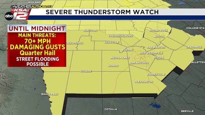
A Severe Thunderstorm Watch is in effect until midnight. (Copyright KSAT-12 2026 – All Rights Reserved)
We are starting the night with a Severe Thunderstorm Watch being issued for most of South Central Texas until midnight. In addition, the Storm Prediction Center has placed parts of the Hill Country and the Austin Metro Area under a Level 3 (out of 5) risk, and the San Antonio Metro area under a Level 2 risk for severe storms tonight.
The window for storms:
Hill Country: 8 PM SUNDAY – MIDNIGHT
San Antonio metro: 9 PM Sunday – 2 AM Monday
Severe risk is highest in the Hill Country, but we’ll all need to be on alert for severe storms (Copyright KSAT-12 2026 – All Rights Reserved)
Some of these storms could turn strong to severe, with the main threats being damaging wind gusts, quarter-sized hail, and locally heavy rainfall, which could cause brief street flooding.
SEVERE STORM POTENTIAL IMPACTS
The greatest threat with any storms tonight are damaging straight-line wind gusts of 70 mph or greater. These kinds of wind gusts can cause power outages and snap branches and trees. While it is impossible to pinpoint exactly where these gusts will occur, you can take some action today to prepare for this possibility:
Secure any loose patio furniture, trampolines, car ports, etc.
Park in the garage if you can, and if you can’t: make sure your vehicle is not parked under trees!
Have a way to get warnings if the power goes out. Make sure your cell phones and devices are charged.
Sunday night’s storm chance and what you need to know (Copyright KSAT-12 2026 – All Rights Reserved)
Storms should move out quickly, with most areas clearing by early Monday morning.
EXTENDED FORECAST
Behind the cold front, weather conditions become quieter and more comfortable. Monday temperatures will dip slightly, with highs in the upper 70s to low 80s, followed by a gradual warming trend through the week. Expect plenty of sunshine and dry weather, with highs returning to the 90s by late week.
Extended Forecast (Copyright KSAT-12 2026 – All Rights Reserved)Daily Forecast
KSAT meteorologists keep you on top of the ever-changing South Texas weather.
QUICK WEATHER LINKS
Copyright 2026 by KSAT – All rights reserved.