
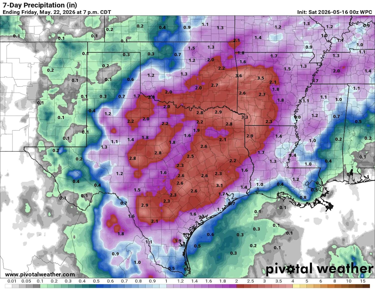
After a stretch of dry weather, we are preparing for a more active weather pattern beginning Sunday and continuing through the work week.
The blocking ridge of high atmospheric pressure that dominated last week’s weather has moved out of the state. In its place, an upper-level trough of low pressure, now positioned over the central Rockies, is expected to send a series of atmospheric disturbances into the Lone Star State throughout the upcoming week.
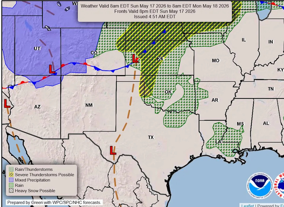
A cold front will begin moving into Texas Sunday night, but its southward progression will be slow, likely not reaching Central Texas until the middle of next week. (Weather Prediction Center)
Over the past several days, surface winds across Central Texas have been flowing in from the Gulf of Mexico, bringing a noticeable increase in heat and humidity. At the same time, southwesterly flow in the mid-levels of the atmosphere from the Pacific Ocean has pushed more clouds into the region.
With these atmospheric ingredients coming together, conditions will be favorable for increased moisture and atmospheric instability, which could lead to rounds of strong thunderstorms this week, including pockets of especially heavy rainfall.
A cold front will slide into Texas on Monday, but it will take some time to reach our area as it stalls out just north of our region. Then on Tuesday and Wednesday it will finally drop south across Central Texas with ongoing active weather through Friday.
Currently, the National Weather Service’s Storm Prediction Center has placed North Texas under a severe weather threat on Sunday and Monday, but we’ll be watching closely to see if that risk expands farther south. Meanwhile, the weather service’s flood forecasters at the Weather Prediction Center are already signaling a strong potential for heavy rainfall across the Austin area, with Central Texas so far under a minimal level 1 out of 4 risk, or at least a 5% chance, of flash flooding.
One other thing to note in the forecast is the above-normal heat expected early in the week. Afternoon temperatures will climb into the lower 90s, but with the added humidity, the heat will feel more like the mid-90s to near 100 degrees, particularly from Sunday through Tuesday. Once a cold front moves through by midweek, cooler air will settle in, bringing afternoon temps back down into the mid-80s for the remainder of the week.
While the rain will be beneficial across much of Texas, especially with severe drought still in place, it will be particularly welcome in the Texas Panhandle, where more than 15 wildfires have ignited over the past week, burning 45,000 acres. Fortunately, many of the fires have been contained quickly.
One of the largest blazes, the Hungate Fire, is burning south of Amarillo and spread rapidly at times. Because of the fire’s proximity, authorities were forced to evacuate Palo Duro Canyon State Park as a precaution.
Ahead of the front on Sunday and Monday, critical fire weather — or conditions favorable for fast-spreading wildfires — is expected with winds blowing out of the west and southwest at 30 to 35 mph. The Texas A&M Forest Service has placed this area under a “very high” to “extreme” wildfire threat for Sunday.
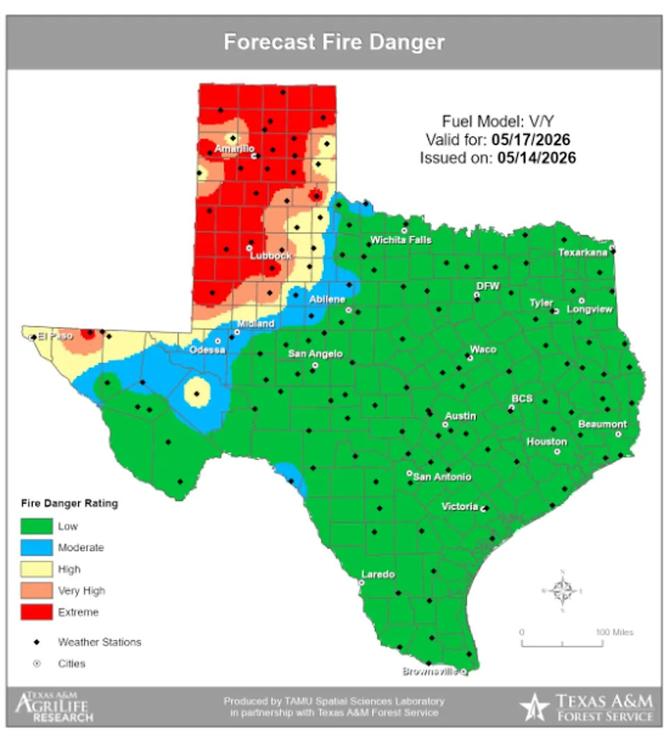
While Central Texas is not currently facing a significant wildfire threat thanks to recent rainfall, the Texas Panhandle could greatly benefit from more rain, as extremely dry weather continues to keep the wildfire danger elevated across the region. (Texas A&M Forest Service)