
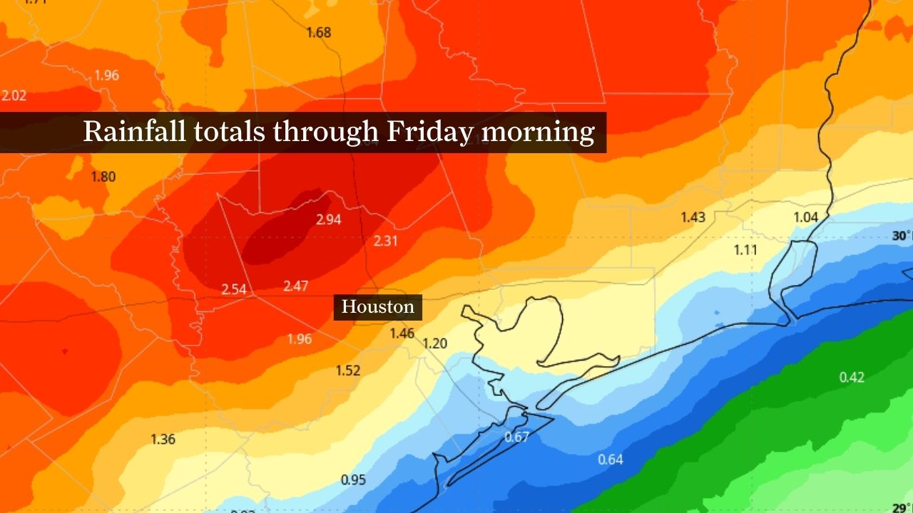
A wet pattern could bring 1 to 3 inches of rain to much of Southeast Texas, including Houston, through Friday morning, as shown by this forecast rainfall map.
WeatherBELL
Houston is heading into a wetter, stormier pattern this week, as rain and thunderstorm chances increase across Southeast Texas beginning Tuesday.
Monday still appears relatively quiet overall, but scattered showers and thunderstorms may become more common through the middle and latter half of the week. The challenge will be pinpointing when each round develops, since much of the activity will depend on smaller-scale disturbances and leftover storm boundaries.
Bottom line:
Monday looks relatively quiet across Houston
Rain and storm chances increase Tuesday through Saturday
Storms will likely remain scattered at times, not all-day rain
Some heavier storms could produce localized flooding
Highest rain totals may occur north of Interstate 10
Article continues below this ad
Houston’s driest day of the week: Monday
Monday should bring another warm and humid day across the Houston area, although a few isolated showers or thunderstorms cannot be ruled out.
Most areas are expected to remain dry for much of the day with highs climbing into the upper 80s to near 90 degrees. Humidity levels will remain elevated as Gulf moisture continues streaming inland.
HURRICANE SEASON CHANGES: Hurricane forecast cone maps are changing this year. Here’s why it matters for Texas.
Article continues below this ad
Some forecast guidance suggests a weak disturbance moving out of Mexico could help spark a few additional showers or storms late Monday into Monday night, but widespread rainfall does not appear likely at this time.
Overall, Monday still looks like one of Houston’s quieter weather days before a more unsettled pattern develops later this week.
Stormy pattern returns to Houston by Tuesday
The overall pattern turns more active beginning Tuesday as deeper Gulf moisture combines with several disturbances moving through southwest flow aloft across Texas.
This image shows how future radar could look Tuesday evening across Texas as a cold front approaches the Houston area.
Pivotal Weather
At the same time, a weakening front sagging into North Texas may help trigger clusters of showers and thunderstorms that could drift closer to Southeast Texas later in the week. Leftover outflow boundaries from earlier storms may also serve as additional triggers for new development.
Article continues below this ad
That setup favors repeated rounds of scattered showers and thunderstorms from Tuesday into at least Saturday, although it will likely not rain continuously for days at a time.
Instead, much of the activity may follow a more typical late-spring pattern, with storms developing during the afternoon and evening before gradually weakening overnight. However, stronger disturbances moving overhead could still trigger occasional nighttime storm complexes.
Multiday flood risk arrives later this week
Much of this week’s rainfall would be beneficial heading into summer, especially on the heels of the drought that began last fall.
Current projections suggest many areas along and north of Interstate 10 could pick up 2 to 4 inches of rain over the next seven days, with somewhat lower totals farther south toward the coast.
Article continues below this ad
HOUSTON WEATHER [SIMPLIFIED]: Sign up to receive forecast updates sent straight to your phone on Fridays and Mondays.
Still, isolated heavier totals cannot be ruled out if stronger clusters of storms repeatedly move across the same locations. That means some localized flooding concerns may develop later this week, especially in areas that see multiple rounds of heavy rainfall.
For now, the biggest takeaway is that Houston appears headed into a wetter, stormier stretch of weather this week, even though the exact timing of each round remains uncertain.