
NOAA’s Weather Prediction Center is projecting rainfall across the United States through Memorial Day weekend. A bull’s-eye of heavy rainfall centered over Houston could make the metro area the wettest spot in the country this weekend.
NOAA’s Weather Prediction Center / Pivotal Weather
Repeated thunderstorms could make the Houston area one of the wettest places in America over the next seven days.
New projections from NOAA’s Weather Prediction Center show widespread rainfall totals of 4 to 8 inches across parts of Southeast Texas through next week, with isolated higher amounts possible where thunderstorms repeatedly track over the same locations. The latest national rain outlook places the Houston region within one of the nation’s most active corridors for heavy rainfall.
The setup is not tied to a tropical system or single storm complex. Instead, it’s being driven by a broader atmospheric pattern that favors repeated thunderstorm development across Texas for days — and potentially weeks — at a time.
Article continues below this ad
What’s driving Houston’s prolonged wet pattern?
Deep volumes of air moisture from the Gulf of Mexico is streaming into Texas, while a stalled dip in the jet stream over the western United States is funneling atmospheric disturbances toward the state — a classic setup for repeated thunderstorms across Southeast Texas.
MAY FLOODING: April showers often lead to May floods in Texas. Here’s how many flash floods have occurred in May.
In Southeast Texas, the atmosphere is already unusually moisture-rich for late May, meaning any storm that develops will be capable of producing torrential downpours in a short period. Afternoon heating alone should be enough to trigger scattered storms on some days.
Article continues below this ad
But stronger atmospheric disturbances moving overhead could organize thunderstorms into larger complexes that would become capable of producing widespread heavy rainfall, gusty winds and overnight storms.
Thursday morning brings the next round of storms as another atmospheric disturbance pushes into Southeast Texas from the west.
Individual waves of storms could drop anywhere from a half-inch to 3 inches of rain across parts of the region, with locally higher totals possible where storms repeatedly move over the same areas.
How long will Houston’s wet weather last?
The broader North American weather pattern also favors a prolonged delivery of atmospheric moisture into Texas.
Article continues below this ad
The outlook through early June from NOAA’s forecasters at the Climate Prediction Center continue to favor a setup with persistent Gulf moisture streaming into the southern Plains and Gulf Coast states. That pattern is being reinforced by a strong high pressure system over eastern Canada and a lingering dip in the jet stream across the western United States.
Together, those features help maintain a steady feed of humid Gulf air into Texas while allowing periodic atmospheric disturbances to move overhead.
Houston’s longer-term forecast doesn’t feature nonstop rain, but rather an atmosphere that can regenerate clusters of thunderstorms every day. Forecast model guidance also continues to favor above-normal rainfall across the western Gulf Coast into early June, suggesting the current stretch of wet weather could persist well beyond Memorial Day weekend.
INFLUENCE OF ‘LA NADA’: How will the absence of La Niña or El Niño shape Texas weather, hurricanes?
Article continues below this ad
One challenge with this type of weather is predicting the timing.
Many of the atmospheric disturbances responsible for triggering storms are difficult to identify more than 12 to 24 hours in advance, making it harder to pinpoint exactly when and where the heaviest rainfall will develop several days out.
When does Houston’s flood risk increase?
Flood potential through Friday remains relatively localized, but that could change as rainfall totals build over several consecutive days.
Initially, most areas should be able to handle another round or two of heavy rainfall without major flooding beyond the typical street flooding and poor drainage that’s common during Southeast Texas thunderstorms.
Article continues below this ad
However, repeated storms will gradually saturate soils as we head into the holiday weekend, increasing the risk for localized flash flooding. We could see overflows on creeks, bayous and rivers if heavier rainfall repeatedly targets the same communities.
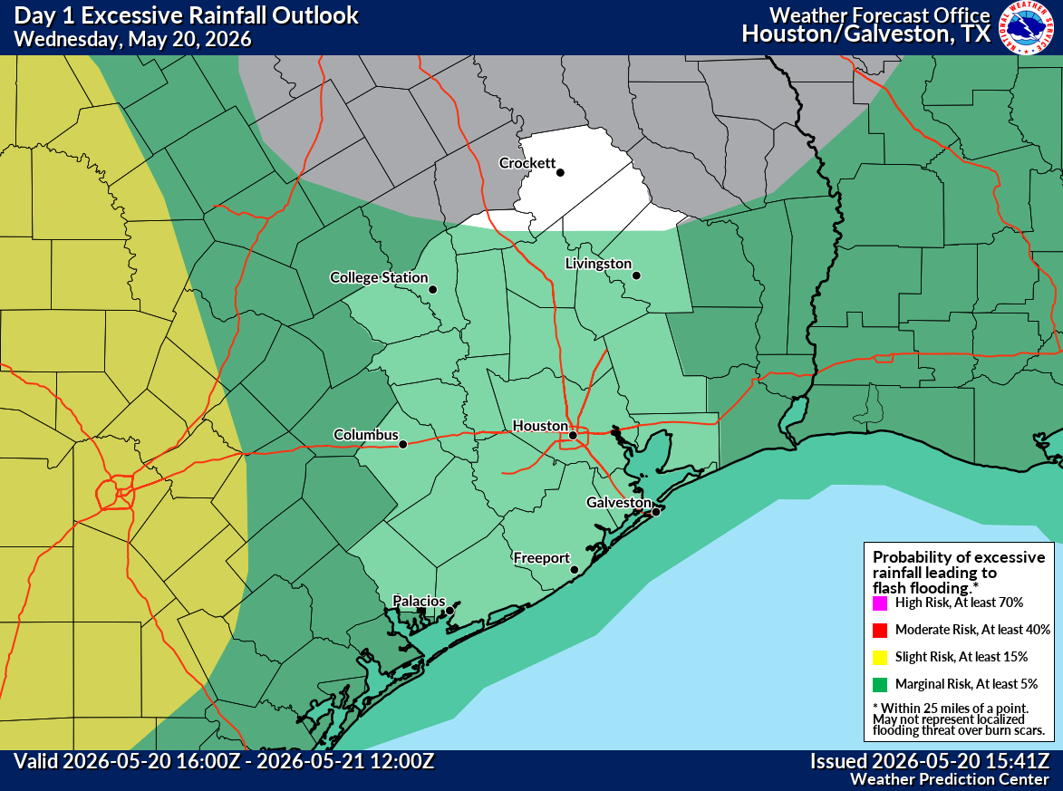
NOAA’s flood forecasters at the Weather Prediction Center already have placed portions of Southeast Texas under a level 2 of 4 risk, or at least a 15% chance, of flash flooding on Thursday, especially closer to the Brazos Valley. Meanwhile, the Houston metro area remains under a minimal level 1 of 4 risk, or at least a 5% chance, of flooding from excessive rainfall.
Wednesday’s flood risk arrived in Southeast Texas as a line of storms pushed through region early in the day.
NOAA’s Weather Prediction Center
Another thunderstorm complex is expected to arrive Thursday, hitting Southeast Texas likely before noon.
NOAA’s Weather Prediction Center
Fewer downpours Friday could ease flood concerns in Southeast Texas, which will be under a slightly lower flood risk.
NOAA’s Weather Prediction Center
More downpours are expected to bring a heightened flood risk to Southeast Texas again by Saturday.
NOAA’s Weather Prediction Center
Repeated rounds of heavy rainfall will keep Houston’s flood risk elevated through much of the Memorial Day weekend.
NOAA’s Weather Prediction Center
The holiday weekend forecast currently favors repeated periods of thunderstorms mixed with stretches of rain-free but humid weather. Outdoor plans across the Houston area will likely need flexibility from Friday through Memorial Day as rounds of lightning and downpours periodically interrupt the weekend.
With little sign of the overall setup changing soon, Southeast Texas could remain locked into an unusually active stretch of weather beyond Memorial Day.