
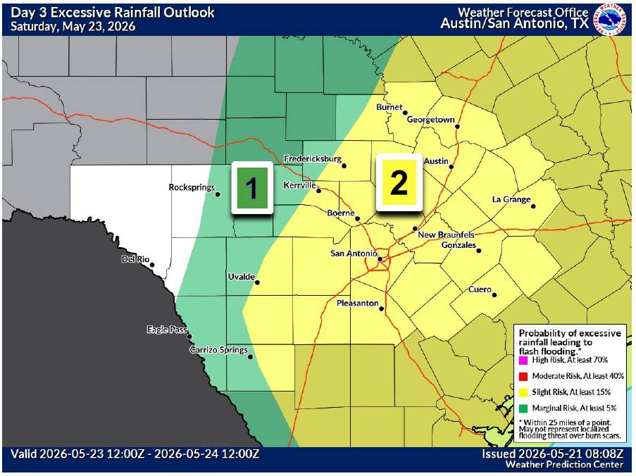
Torrential downpours will accompany showers and thunderstorms in Texas this weekend, with the highest flash flooding threat expected from Saturday into Sunday. The Weather Prediction Center has placed parts of Central Texas under a level 2 out of 4 risk, or at least a 15% chance, of flooding from excessive rainfall on Saturday.
National Weather Service
We’ve finally made it to the Memorial Day holiday weekend, what some call the unofficial start of summer. Whether you’re traveling across Texas, planning a “stay-cation,” or heading to a lake or a pool, or exploring the greenbelts and hiking trails around Central Texas, it will be important to stay weather-aware and make flood safety plans.

An active and unsettled weather pattern will continue through the weekend and into next week. A trough of low air pressure over Baja California will gradually make its way northeast across Texas through Sunday. This system will trigger multiple rounds of thunderstorms capable of producing heavy rainfall and localized flooding.
Article continues below this ad
Because of the increasing flood threat, the National Weather Service has issued a flood watch for Central Texas, effective at 7p.m. Friday and continuing through Memorial Day.
A flood watch will be in effect Friday night until Monday evening for much of Central Texas.
National Weather Service
“As each round of storms moves across portions of our area, more stable conditions behind these features will allow for periods of dry weather as well, as the atmosphere recharges,” meteorologists at the National Weather Service wrote in their daily forecast discussion for Central Texas.
But figuring out how each round of storms will influence the formation of the next, uncertainty remains in the forecast.
Article continues below this ad
“So, while prolonged chances for precipitation are seen in the extended forecast, periods of dry weather are also expected,” forecasters said. “As each round helps determine the set up for the next, it’s hard to say with confidence exactly when dry and wet periods will be, hence, the continued rain chances.”
Dry and mild Friday
We’ll wake up to some scattered showers and storms moving out of the region. Expect a mostly dry but cloudy day, basically sandwiched between a departing upper-level atmospheric disturbance in the east and an incoming disturbance in the west.
Article continues below this ad
Afternoon temperatures will climb into the middle and upper 80s, which is right on target for the average May 22 high of 88 degrees.
Temperatures on Friday could reach the middle to upper 80s across Central Texas.
Pivotal
A wet Saturday
Central Texas will remain under a southwesterly air flow in the upper levels of the atmosphere, with several atmospheric disturbances embedded within that flow. One disturbance will move across the region on Saturday, providing the necessary lift in the atmosphere, while warm temperatures and high humidity will provide fuel for showers and thunderstorms.
Article continues below this ad
Stay weather aware this weekend as more rain is expected, especially on Saturday and Sunday. A Flood Watch has been issued for all of Central Texas from Friday night through Monday evening. #txwx pic.twitter.com/xEsDEdGva3
— Mary Wasson (@Mary_Wasson) May 21, 2026
A complex of storms is expected to develop in West Texas early Saturday before tracking east through the afternoon and evening. Pockets of heavy rainfall could lead to instances of flash flooding, especially in areas under a level 2 out of 4 risk, or at least a 15% chance, of flooding from excessive rainfall from the weather service’s Weather Prediction Center.
Temperatures on Saturday will start near 70 degrees in the morning and then reach only the upper 70s and lower 80s by the afternoon. Winds will be light out of the south between 5 and 10 mph.
Complicated forecast Sunday through Wednesday
The upper-level low pressure system is expected to remain stalled over Texas through Monday, but the big question is exactly where it sets up. If it lingers over Central Texas, the potential for more rounds of heavy rainfall will increase. However, if the system shifts farther to the northeast, rainfall amounts would likely be more manageable.
Article continues below this ad
For now, rain chances remain solid throughout the holiday weekend.
Rain and thunderstorms will continue off and on in Austin throughout the weekend with heavy rainfall likely. A flood watch will be in effect from Friday night until Monday evening.
National Weather Service
Another trough of low pressure then digs in over the western United States towards the middle of next week. That will help move our stalled system along, but it also will reestablish southwesterly flow over the area and maintain rain chances.
Article continues below this ad
Overall, rainfall totals over the next week will range from 3 to 5 inches with isolated instances of higher amounts.
Over the next week, areas along and east of Interstate 35 in Texas will pick up 3 to 5 inches of rainfall.
Pivotal