
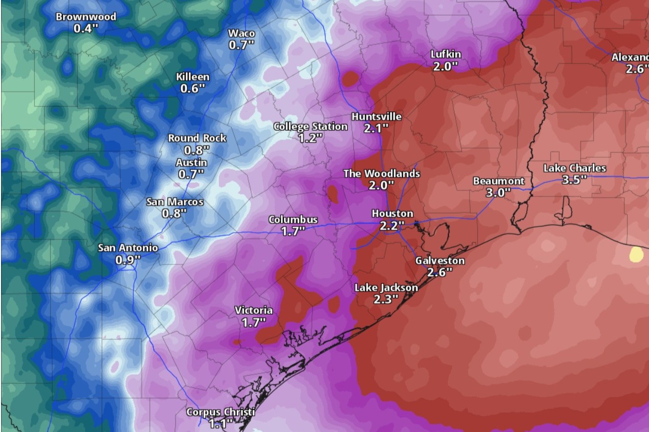
Cumulative rainfall projections through 7 p.m. Monday show amounts of at least 2 inches across Southeast Texas, according to the National Blend of Models, a composite forecast model.
National Blend of Models/Pivotal Weather
Coastal counties in Southeast Texas remain under a flood watch through Monday morning, the National Weather Service said, while multiple rounds of thunderstorms are expected to roll through the Houston metro area over the Memorial Day weekend and into next week.
Some of the holiday weekend storms will be strong but not severe, so the weather threat will be limited to mostly heavy rainfall and flash flooding.
“With the amount of moisture that is to be in place, it will be of no surprise for moderate to heavy rainfall to develop (some showers could even produce rainfall rates of 2 to 4 inches per hour),” weather service meteorologist Amaryllis Cotto wrote in a forecast bulletin Friday. “Given that soils are fairly saturated from the rains we have received over the last few days, it will not take much for heavy rainfall to cause runoff and/or flooding impacts — in particular over the coastal areas.”
Article continues below this ad
Here’s an updated timeline of storm activity, based on the latest forecasts from the weather service.
Coastal counties in Southeast Texas remain under a flood watch through Monday morning, the National Weather Service said.
National Weather Service
Friday
Afternoon: The Houston area on Friday has a 50% chance of showers and storms kicking in after 10 a.m. on an otherwise mostly sunny day. Daytime temperatures could peak at 87 degrees, which is fairly close to normal for May 22.
“Speaking of heat, it will remain rather humid on Friday with highs in the mid- to upper 80s and heat indices in the lower to mid-90s,” Cotto said.
Article continues below this ad
Night: Houston only has slight rain chances (20%) between 8 p.m. and 9 p.m. under partly cloudy skies. Nighttime temperatures will stay above a balmy 74 degrees.
“Rain activity will decrease Friday evening as we lose the (daytime) heating,” according to Cotto. “There will be storms developing to our north, thus, we will need to keep an eye for the possibility of these storms rolling into the Brazos Valley and Piney Woods region.”
Any new rainfall amounts in the Houston area would likely be less than a tenth of an inch, forecasters said.
An upper-level trough of low atmospheric pressure will move across Texas and will combine with air so heavily saturated with water vapor that the air could yield up to 2 inches of rain.
Weather Prediction Center/National Weather Service
Saturday
Morning: With temperatures starting in the lower to mid-70s, the weather is expected to become much more active on Saturday.
Article continues below this ad
Afternoon: An upper-level trough of low atmospheric pressure will move across Texas and will combine with air so heavily saturated with water vapor that the air could yield up to 2 inches of rain.
“This will lead to several rounds of showers and thunderstorms through much of the day and night,” Cotto said. The weather service forecast Friday said storm chances would be highest (80-90%) after 1 p.m. Meanwhile, temperatures could climb to as high as 84 degrees, which would slightly lower thanks to rain-cooled air.
Night: Rain is all but certain across the Houston area as storm chances reach 90% on Saturday night. Temperatures stay largely in the 70s overnight. New rainfall amounts during this period would be between a quarter-inch and a half-inch, forecasters said.
“In addition to the locally developed activity, we might have the storms that developed to our north and west roll in, which can account for higher rain chances,” Cotto said in her forecast.
On Sunday, another upper-level trough of low atmospheric pressure will move across Texas.
Weather Prediction Center/National Weather Service
Sunday
Morning: The flood watch for the coastal counties in Southeast Texas is set to continue through Sunday and into Monday. The flood watch area currently centers on those counties south of Interstate 10 and west of Interstate 45, but it could be expanded throughout the weekend.
Article continues below this ad
“The environment will remain favorable for additional showers and thunderstorms on Sunday as another upper-level trough pushes across Texas,” Cotto said.
Although some of the heaviest rainfall is expected near and south of I-10 and east of I-45, “let’s not sleep on that, given that the placement of activity could end up either more north or even over the waters,” Cotto warned, adding that uncertainty still remains about exact locations of storms.
Afternoon: With rain chances in the Houston metro area hovering around 80%, showers and possibly storms will persist Sunday afternoon, limiting daytime temperatures to the lower 80s.
Night: Rain chances in Houston ease to around 50% under partly cloudy skies and temperatures no lower than 71 degrees.
Monday
Memorial Day in Houston has a 50% chance of showers and storms under otherwise mostly sunny skies. Should you be able to enjoy the holiday outdoor, temperatures should peak in the afternoon around 85 degrees. Rain chances diminish to about 30% in the evening.
Article continues below this ad
“Even if the potential for heavy rainfall ends up being less, even moderate rain can lead to minor flooding impacts over those areas affected by heavy rainfall from Saturday and Sunday,” Cotto said.