
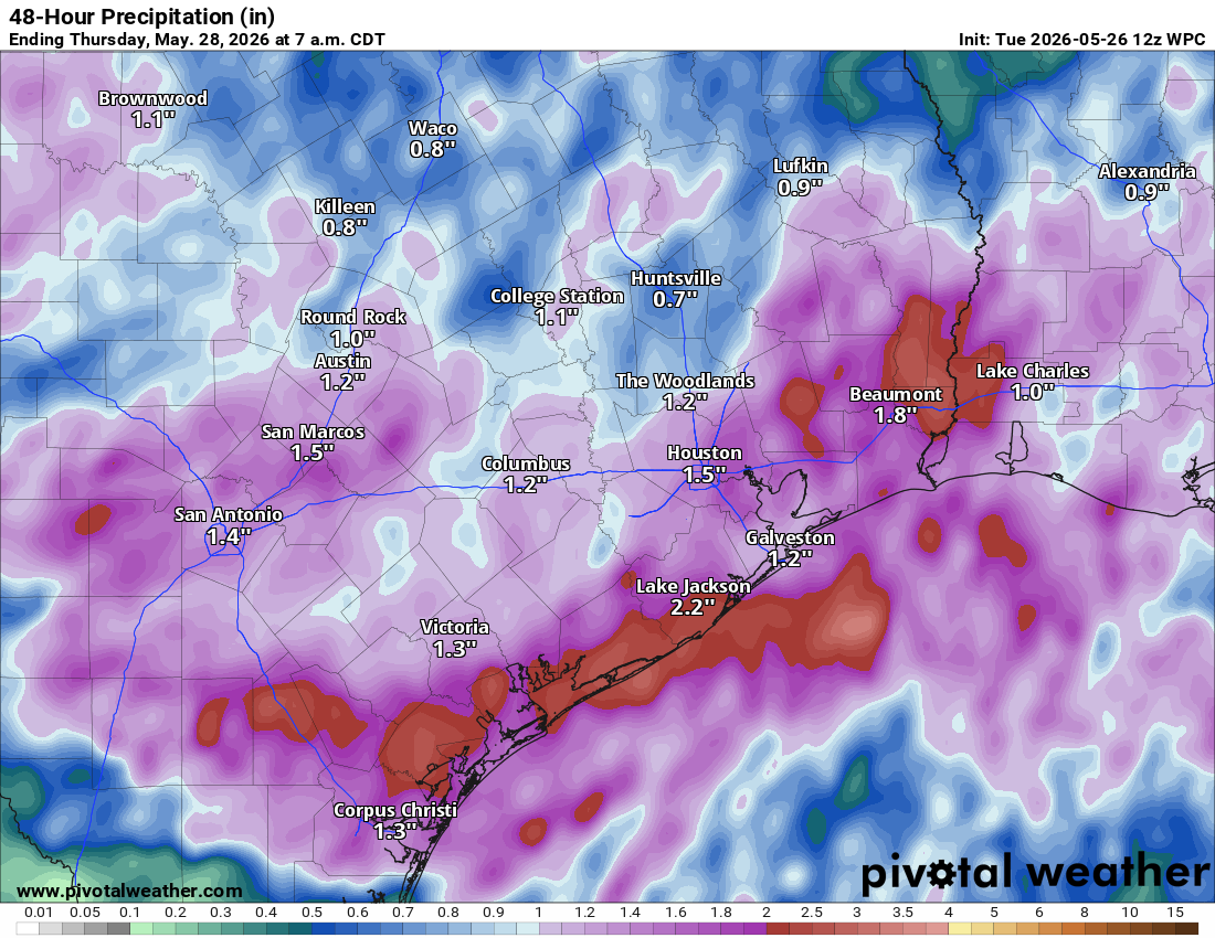
That calmer pattern will shift, however, as a renewed round of widespread heavy rainfall and potentially strong thunderstorms develop on Tuesday and Wednesday.
After the recent rounds of heavy rainfall, the soils remain saturated across parts of Central Texas. With another dose of heavy rainfall expected, much of the water will quickly turn into runoff, increasing the risk of flooding concerns.
In anticipation of that threat, the National Weather Service has issued a flood watch for Central Texas from 4 p.m. Tuesday through Wednesday morning.
“Showers and thunderstorms will be capable of producing high rainfall rates which could quickly lead to flooding across the watch area,” meteorologists at the National Weather Service wrote in their weather alert. “Be especially cautious as creeks, streams, and rivers may rise out of their banks quickly. Rainfall amounts of 1 to 3 inches with isolated amounts up to 5 inches are possible for the duration of the flood watch.”
A weak mid-level trough of low atmospheric pressure, accompanied by a front, is positioned over southern New Mexico and Far West Texas. This upper-level atmospheric disturbance will slowly shift eastward into the Permian Basin and Concho Valley Tuesday afternoon and evening.
Meanwhile, a weak area of low pressure near the Big Bend region will continue to funnel moist, easterly winds from the Gulf of Mexico into the Edwards Plateau.
While much of Tuesday afternoon in Austin is expected to remain dry, thunderstorms are forecast to develop by early afternoon, around 2 p.m. Tuesday, farther west near the Edwards Plateau and Rio Grande Plains.
Those storms are then expected to push eastward as a mesoscale convective system, a large, organized cluster of thunderstorms that can persist for several hours and cover a much broader area than a single storm.
The leading edge of the storm complex will move into Hill Country around 7 p.m. Tuesday, into Austin around 9 p.m., then into Bastrop around 11 p.m. Scattered rainfall and thunderstorms will continue overnight and eventually wrapping up around sunrise on Wednesday morning.
The weather service’s Storm Prediction Center has a level 1 and a level 2 out of 5 risk for severe weather along and west of U.S. 281 Tuesday afternoon and evening. The leading edge of storms will bring the best chance for severe wind gusts to be more than 60 mph and hail as large as an inch to 2 inches.
The latest high-resolution forecast model indicates that the storms should wrap up before sunrise on Wednesday, but another short-term forecast model keeps the rain around until late Wednesday morning. We also can’t rule out more showers and an isolated storm on Wednesday afternoon.
However, by Wednesday evening, drier weather will settle into the Lone Star State for the rest of the work week.