
In autumn 2024, US Department of Transportation (USDoT) collectively awarded $60 million to Arizona’s Maricopa County DoT, Texas A&M Transportation Institute (TTI), and Utah DoT to deploy, operate, and showcase secure, interoperable Vehicle to Everything (V2X) deployments.
TTI liked the look of the original Notice of Funding Opportunity when it was released nationwide.
“We felt like we had an opportunity to put forth a project proposal that would be a little different than an IOO [infrastructure owner operator] and covering a broad range of potential applications,” TTI senior research scientist and division head Robert Brydia explains.
“Our interest in V2X has certainly been in play for quite some time and we’ve had previous projects in this arena. The Saving Lives with Connectivity grant was an ideal opportunity to continue to push forward.”
The TTI-led project – Transforming Roads: Unleashing Smart Technologies (Trust) – focuses on 15 different use cases across a 4,000 square mile area including Bryan/College Station and the Greater Houston Metropolitan Area. That’s a very big area, with diverse challenges.
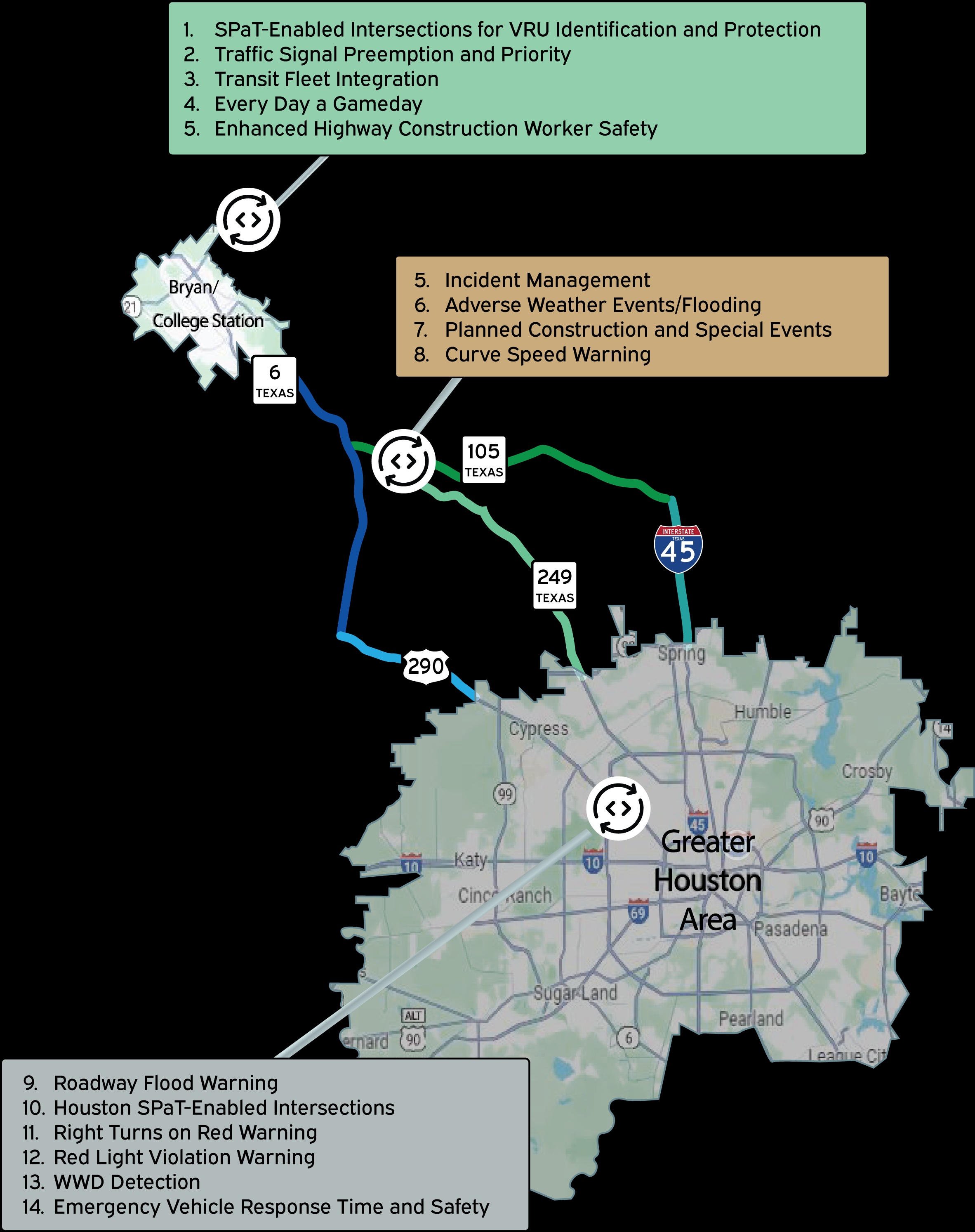
How TTI’s Trust V2X initiative rolls out (image: TTI)
Forward-thinking and progressive
“In general, the region allows for rural, urban and suburban areas and encompasses approximately seven million people,” Brydia explains. “There are dozens of IOOs in the region and we’re lucky enough to work with five that are forward-thinking and progressive in their desire to try innovations on their roadways to improve safety and mobility.”
The IOOs are: Texas DoT (TxDoT), City of College Station, City of Houston, Fort Bend County and Missouri City. Each of the use cases is geared towards safety and mobility.
The choice of IOOs was both strategic and lucky, Brydia admits.
“Obviously, TxDoT went in at the forefront as they are the largest IOO as the state DoT. The City of Houston was engaged with TxDoT in a significant deployment of V2X (SPaT/Map) at 1,100 intersections. The City of College Station has been a long-time collaborator in research endeavours and was enthusiastic about continuing that. Missouri City and Fort Bend County came to the table later as some challenges with the existing infrastructure in other locations became apparent. That’s the lucky part as they were already engaged in V2X programmes on their own and we can both benefit from the collaboration.”
Traveller information
In addition to the five IOOs, there are around 20 other partners on the project, ranging from OEMs to telecoms and data providers to ITS equipment suppliers and deployers. “Guiding them all towards fulfilling the project vision is certainly a significant undertaking,” Brydia says.
“That’s not to say there’s infighting or anything else—there isn’t. But 25 different organisations and agencies mean there are multiple opinions and thought processes that must be navigated towards unity.”
It’s Brydia’s job as Smart project lead to lay out the vision and lead everyone on that path – but he insists that TTI has learned from its partners, too: “Everyone brings something to the table and has their own areas of expertise and contributions.”
 “The world isn’t going to switch to fully-equipped, connected vehicles for at least two decades—we have to do something in the meantime” Robert Brydia, TTI
At its core, he sees V2X as traveller information—a conversation between vehicles and infrastructure. “We’ve been doing that in transportation for decades; with signs, signals, markings, flaggers in construction zones, horns, inappropriate hand gestures,” Brydia continues. “V2X is the next generation of that messaging – electronic – without the inappropriate hand gestures!”
TTI favours a combination of Direct and Network V2X. “Direct is where information is broadcast from the side of the road into vehicles at the location to receive it in a time-sensitive manner for safety critical items, like conflicts at intersections,” he explains.
“Network is where the information goes up into the cloud and then we are integrating it into a development version of Google Maps to showcase the consolidation and single access point of numerous types of traveller information.”
Larger scale
A combination of the two makes sense.
“Direct is broadcast directly into the air to approaching vehicles and so has a range of approximately 1,000 feet,” Brydia points out.
“So while it’s very fast, you can only affect vehicles in the immediate vicinity of the information need. That works out well for things like intersections, but is very inopportune for needs that are on a much larger scale, such as flood warning and wrong-way driving. In those cases, you want to alert people in a much wider swathe of the transportation system—that’s the value of Network use cases where you send the information to the cloud and then disseminate from there.”
Not that Network is perfect either, of course. “The challenge with Network is the same with all traveller information—you get a full situational awareness, you need 43 websites, two emails, four text messages, five apps on your phone, etc!” he says. “There’s no centralisation of the information.”
Hence the collaboration with Google on building the development version of Google Maps which will consolidate all the Network use case information/alerts into a single cohesive platform.
“This has never been done before,” Brydia says.
“In the future, we’d like to bring in Direct messages as well—for the moment, that’s handled by OEMs and their telematics platforms, but the world isn’t going to switch to fully-equipped, connected vehicles for at least two decades—we have to do something in the meantime. Google Maps provides an opportunity to showcase what that interim future could be and how powerful it could be.”