
LUBBOCK, Texas (KCBD) – A few strong storms could bring limited heavy rain, hail, and gusty winds to parts of the KCBD/FOX34 viewing area this evening. The threat drops off significantly until late Friday, when another chance of storms arrives.
Evening Storm Outlook
Scattered thunderstorms will be possible through this evening, mainly across the northern and eastern KCBD/FOX34 viewing area. A few of these storms could be strong, with wind gusts potentially up to around 60 mph and hail near an inch in size. The severe threat is minimal overall, but it’s something to keep an eye on this evening, especially if you will be outside. As the low pressure system that’s been sitting over the Texas Panhandle drifts eastward into early Thursday morning, storm chances will diminish.
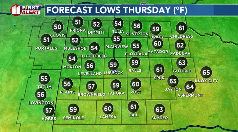 Thursday morning lows near average for late May.(KCBD First Alert)
Otherwise tonight will be rather calm with a light breeze and lows near average for the time of year.
Warmer Thursday
Thursday in generally will be a quieter day. An upper ridge of high pressure will move over the forecast area, which will help warm things up a bit compared to Wednesday and suppress storm development. A storm or two, however, will be possible in the area with the residual humidity and late afternoon heat.
The overall threat is quite low. Any storms that do pop up Thursday would have even less severe potential than what we may see this evening.
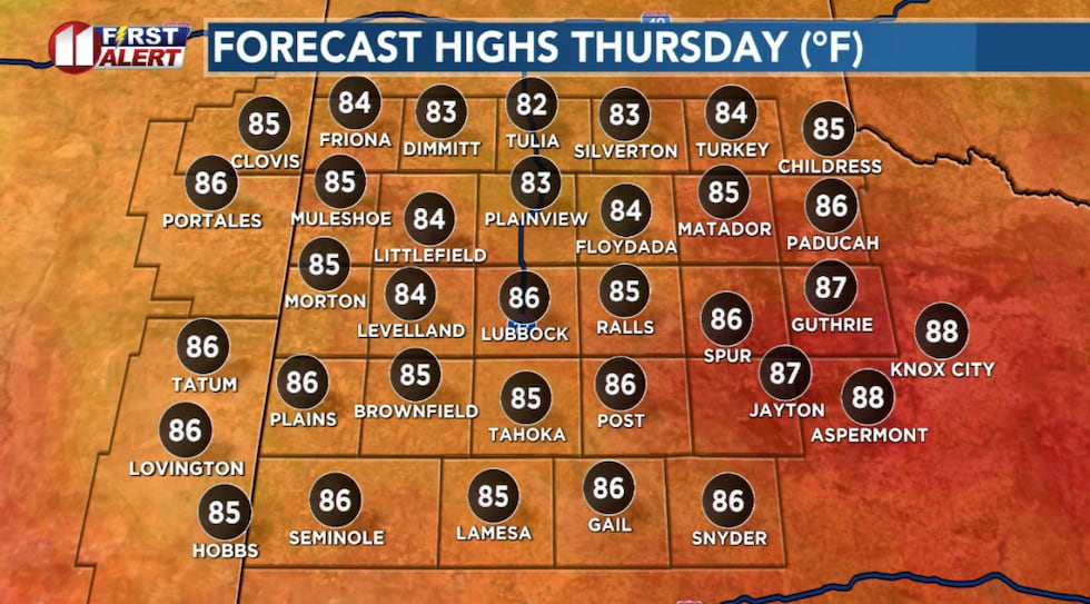 Temperatures will peak slightly below seasonal averages Thursday afternoon.(KCBD First Alert)
Temperatures will edge up a bit more, peaking slightly below average for the end of May.
Storms Return
Friday brings an increase in storm, and therefore rain, chances. An upper-level low pressure area moving in from the west will enhance lift over the area just as a dryline pushes eastward from New Mexico. This setup should spark some storms, though the coverage is unknown at the moment.
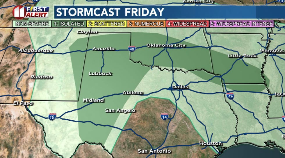 Scattered storms may bring a slight severe threat late Friday.(KCBD First Alert)
Based on current data, there is a marginal risk of some storms becoming severe.
The Weekend
Saturday is shaping up hot and dry. Currently I anticipate highs near to slightly above average for the end of May. There may be some storms as well, though currently it appears any activity will be near or east of the eastern edge of the KCBD/FOX34 area.
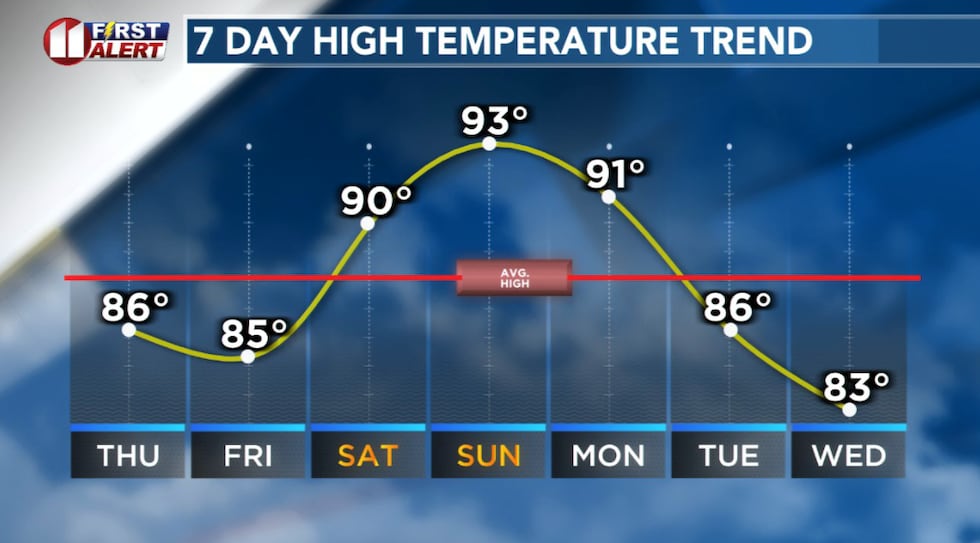 Lubbock’s average high temperature at the end of May is 88°.(KCBD First Alert)
Summer-like heat – well, it is that time of year – returns Sunday. Much of the area will have highs in the 90s. At this time, storms are not expected. With the heat, however, a spotty storm or two may pop up.
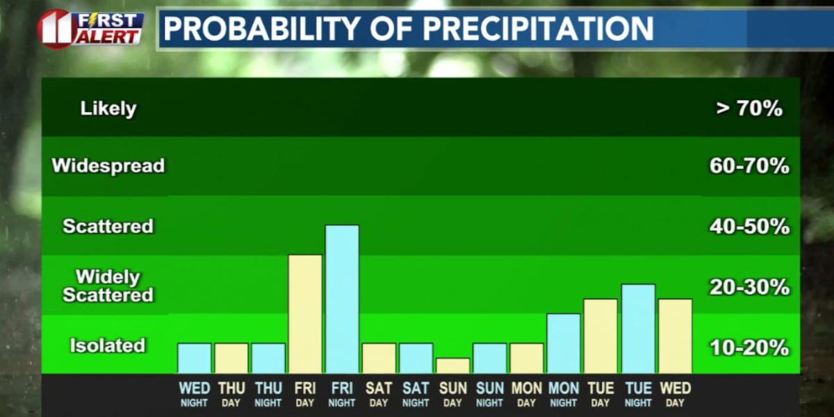
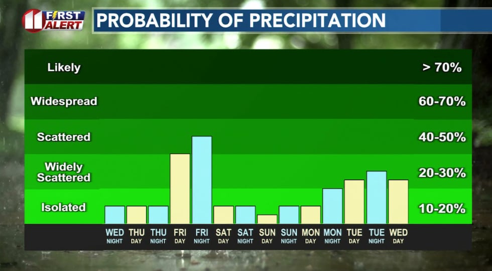 Slim storm/rain chances through Thursday night, with increasing chances Friday.(KCBD First Alert)
Keep an eye on the sky this evening if you’re in the northern and eastern viewing area. After that, Thursday looks pretty quiet, Friday brings another round of storms, and the weekend will be heating up.
On This Date
On this date in 1980, a late afternoon tornadic supercell thunderstorm developed in southwest Lubbock County near Slide. Four men working on an oil rig nearby took shelter in a nearby ditch (which was the correct action if there was no suitable structure nearby) as the tornado approached the work site. The derrick was pushed into the mud pits damaging the derrick, the substructure and 10,000 feet of pipe. Fortunately the men were not injured. Near Shallowater, another tornado touched down causing some damage to structures as it continued northward to just north of Abernathy.
(Source: National Weather Service, Lubbock)
 First Alert Weather App(KCBD)
Copyright 2026 KCBD. All rights reserved.