
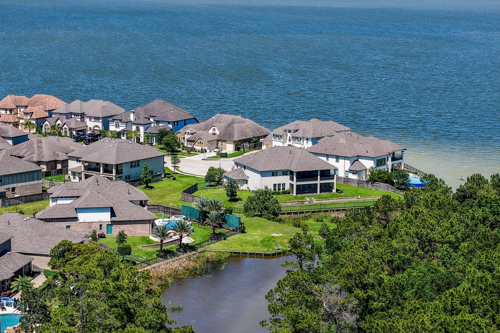
It’s been more than two months since the Federal Emergency Management Agency and the Harris County Flood Control District released the long-awaited draft maps highlighting updated flood risks across the region.
While the data is a work in progress, some local homeowners said they are wondering how the changes will impact their bills.
The big picture
FEMA requires all property owners with a federally-backed mortgage living in a 100-year floodplain—areas with a 1% annual chance of flooding—to obtain flood insurance through private insurers or the National Flood Insurance Program, known as NFIP. A before-and-after glimpse of the preliminary maps indicates more Lake Houston-area homes fall within a high- or moderate-risk flood zone, potentially impacting flood insurance requirements for certain residents. The February draft reflects nearly two decades of change, as FEMA last released flood maps in 2007 using data from Tropical Storm Allison, per the agency’s website.

Emily Woodell, HCFCD chief external affairs officer, said new insurance requirements won’t take effect until the map is finalized in two to three years. She said HCFCD doesn’t know the exact number of homes now in a floodplain, but there was a “significant expansion in the maps” driven by a 30% increase in rainfall rates.
“Our stance has always been and will always be that everyone in Harris County should have flood insurance no matter where you live,” she said.
As for cost, Houston-area insurance agent Jose Medrano said every property is unique, and the map alone no longer determines premiums. In 2023, FEMA implemented a new pricing system called Risk Rating 2.0 that uses factors such as home elevation, distance to flood sources and construction history to calculate quotes.
The cost
Medrano said standard homeowners insurance does not cover flood-related damages.
“What [flood insurance] covers is damage to your property if water comes from the ground up,” he said. “Regular home insurance is if the water comes in from the sky down.”
Annual flood insurance costs vary greatly for Harris County residents—anywhere from $500 to more than $1,000—according to FEMA data.
Medrano said residents living outside the 100-year floodplain may be able to buy a NFIP policy at a lower rate. The NFIP also offers discounts for high-risk homes under the new maps.
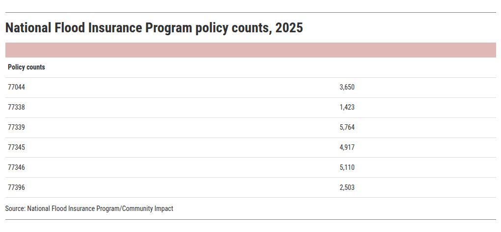
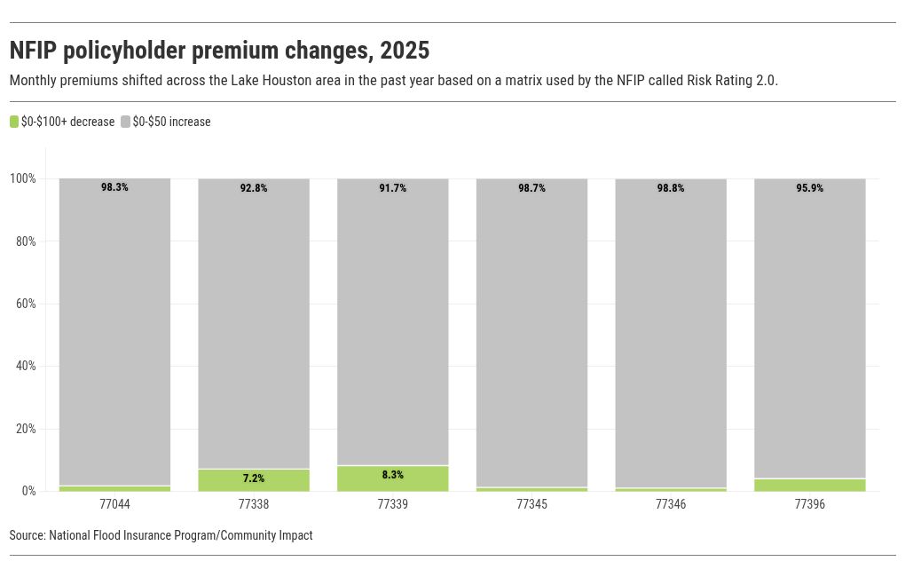 Bob Rehak, a member of the Harris County Community Flood Resilience Task Force, said he has lived in Kingwood for 42 years. He said that his house hasn’t flooded, but the flood levels have gotten closer with each major storm.
“We’ve seen water come across Kingwood Drive four times, and each time, it’s gotten progressively higher,” Rehak said.
Rehak said many people buying homes don’t realize that floodplains are constantly changing due to a variety of factors. Therefore, they can still be at risk, even if their homes are not in a danger zone on the FEMA flood maps.
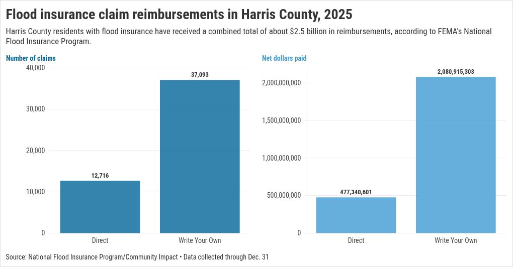 Zooming out
Kingwood insurance agent Jeanna Bumpass—whose own house flooded during Hurricane Harvey—said homeowners need to plan well in advance when obtaining flood coverage.
“Once there is activity in the Gulf, you can’t get flood insurance,” Bumpass said.
 Caption
Check it out
All Harris County residents are eligible to purchase flood insurance through the NFIP, according to the flood control district.
Tips to kick off your flood insurance research:
Visit www.floodsmart.gov and enter details about your property to get a quote.Compare potential changes to your flood zone by visiting www.maapnext.org and entering your address. Use the slide tool to view FEMA’s existing maps versus draft maps.Contact NFIP experts at [email protected] or call 800-427-4661.Reach out to an insurance agent to discuss possible coverage options for your property and personal belongings.Consider obtaining a home inspection and elevation certificate, which may decrease your quote.Sign up for flood alerts at www.harriscountyfws.org.Staying prepared
Woodell said Harris County is at the start of a long process to update the maps and, as a result, finalize insurance changes. In the meantime, she said residents should use the maps to make informed decisions about where their families live, work and play.
Prepare your property for hurricane season:
Research flood insurance policies.Add your agent to your phone contacts and email all important documents to your phone.Take pictures or videos of each room in your home to make a home inventory.Consider comprehensive auto coverage for your vehicle, which covers flood, hail, fire and wind damages.Toughen the exterior of your home with window shutters and a wind-resistant garage door.Prepare your yard by removing dead tree limbs and low-hanging branches.