
FORECAST HIGHLIGHTS
TROPICAL MOISTURE: Tropical moisture moves in next week, bringing higher humidity
SCATTERED DOWNPOURS: Afternoon rain chances Tuesday through Friday
SUMMER-LIKE PATTERN: Typical late-day storms with brief heavy rain and gusty winds
HIT-OR-MISS RAIN: Not everyone sees rain daily, but isolated heavy pockets possible
FORECAST
MONDAY
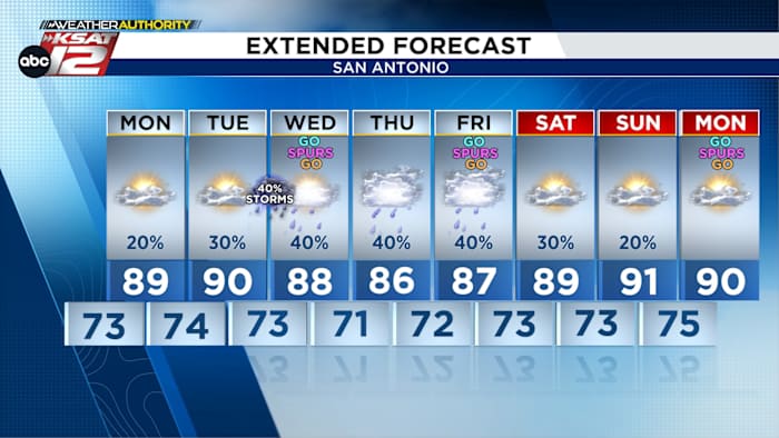
A warm and humid start to the week is expected on Monday, with morning lows in the 70s and afternoon highs climbing into the upper 80s to mid-90s. A broad upper-level ridge will remain in place, keeping conditions mostly dry despite the muggy air mass in place.
MIDWEEK TRANSITION
By Tuesday, the weather pattern begins to shift as that ridge weakens. Deeper tropical moisture will push into the area, increasing humidity levels and helping to spark scattered showers and thunderstorms.
Tropical moisture will move in by the middle of next week (Copyright 2026 by KSAT – All rights reserved.)
Rain chances will rise to around 30% to 40% each day, with activity mainly developing during the afternoon and early evening hours.
NBA Finals Forecast (Copyright 2026 KSAT 12 — ALL RIGHTS RESERVED)
This setup is very typical for early summer in South Texas, with heat and humidity fueling isolated afternoon storms. While not everyone will see rain on a daily basis, any storm that forms could briefly bring heavy rainfall before moving out. The warm, humid, and unsettled pattern is expected to carry into next weekend.
Extended Forecast (Copyright 2026 by KSAT – All rights reserved.)Daily Forecast
KSAT meteorologists keep you on top of the ever-changing South Texas weather.
QUICK WEATHER LINKS
Copyright 2026 by KSAT – All rights reserved.