
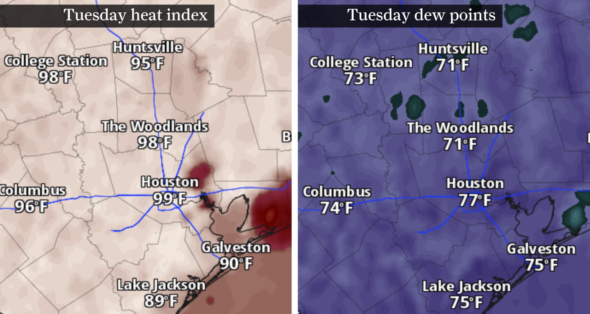
This map shows forecast heat index Tuesday, at left, and forecast dew points, at right. Dew points well into the 70s could make for heat index values between 99 and 105 degrees Tuesday afternoon.
Pivotal Weather
Houston’s summer pattern will become more pronounced Tuesday as humidity pushes heat index values above 100 degrees and afternoon storm chances increase across Southeast Texas.
Tuesday’s muggy forecast arrives just after the start of meteorological summer, which officially kicked off Monday. Temperatures will rise into the low 90s, but increasing moisture will make it feel considerably hotter. That added humidity could lead to scattered showers and thunderstorms, offering some neighborhoods brief relief from the heat during the afternoon and evening.
Houston heat index could reach 105 degrees Tuesday
Although actual temperatures are expected to top out in the low 90s, the combination of heat and humidity will make it feel much warmer during the afternoon.
Article continues below this ad
SEASON KICKS OFF: El Niño is coming and hurricane season starts now. Here’s how Texas will be affected.
Heat index values, or what the temperature feels like when humidity is factored in, could range from 99 to 105 degrees across much of Southeast Texas. While those values remain below heat advisory criteria, they can still be hazardous for anyone spending extended periods outdoors.
Residents planning to work, exercise or attend outdoor events should drink plenty of water, take frequent breaks in the shade or air conditioning and wear lightweight, light-colored clothing whenever possible.
Rain chances increase beginning Tuesday
The same moisture driving up humidity levels will also increase the likelihood of afternoon showers and storms across Southeast Texas.
Article continues below this ad
During the afternoon, scattered storms are expected to develop along the sea breeze, particularly along and south of Interstate 10. Additional thunderstorms could form later Tuesday if the approaching disturbance and boundary provide enough lift across the region, especially north of I-10.
Taken together, those two rounds of storm development give the Houston area roughly a 40% chance of thunderstorms Tuesday afternoon and evening. This second wave of storms could lead to more numerous gusty winds from Lufkin to Conroe, though widespread severe weather is not expected.
Storms could blossom across Southeast Texas Tuesday afternoon, as shown by this future radar snapshot.
Pivotal Weather
As with any storms this time of year, heavy rain and frequent lightning will be a possibility in any downpour that moves overhead.
Any showers that develop could temporarily knock temperatures down a few degrees, offering some welcome relief from hot weather. However, the cooling effects will likely be short-lived as warm, humid conditions quickly return once storms move through.
Article continues below this ad
Looking ahead, rain chances could climb even higher by late week as deep tropical moisture spreads inland from the Gulf of Mexico.
Ways to beat early season heat
Meteorological summer may have just begun, but Southeast Texas is already settling into a weather pattern more typical of July than early June.
Many Houstonians, especially those experiencing their first Houston summer, may not be fully acclimated to the season’s heat just yet. With 100-degree heat index values in the forecast, longtime residents and new Houstonians alike should avoid underestimating how quickly humidity can make outdoor activity feel exhausting this early in the warm season.
Shown is an infographic describing varying symptoms of heat-related illness. It’s important to know the signs of heat exhaustion or heat stroke.
National Weather Service
Residents should consider limiting strenuous outdoor activities during the hottest part of the day, generally between noon and 6 p.m., while taking frequent breaks in the shade or air conditioning.
Article continues below this ad
HURRICANE FORECASTING AND AI: AI breakthrough in hurricane prediction marks major leap for Texas storm forecast accuracy.
Drivers are urged to look before locking their vehicles and never leave children or pets inside parked cars, where temperatures can become life-threatening within minutes.
Pet owners should also keep an eye on pavement temperatures. If the ground is too hot to comfortably touch with the palm of your hand, it’s too hot for your pet’s paws.
Tuesday’s forecast may only be the opening act. With meteorological summer now underway, Southeast Texas is expected to see a familiar mix of heat, humidity and daily storm chances in the days ahead as the region settles into its typical summer weather pattern.
Article continues below this ad