
Welcome to meteorological summer in Central Texas. June marks the beginning of the three-month stretch — June, July and August — that meteorologists and climatologists use to define the hottest time of the year.
However, if you are waiting for the official start of astronomical summer, when the Northern Hemisphere is tilted toward the sun and experiences its longest day of the year, you will have to wait a few more weeks. The summer solstice doesn’t arrive until June 21.
One of the main reasons we see this shift is because the jet stream shifts north of Texas, steering large, organized weather systems such as cold fronts and upper-level lows that typically bring widespread rainfall during the spring into the Central and Northern Great Plains.
Even so, June remains one of Central Texas’ wetter months, ranking as the region’s third-wettest on average, and Austin typically records about 3.68 inches of rainfall. Temperatures trend quickly upward, beginning the month with highs in the lower 90s and overnight lows in the lower 70s before warming into the mid-90s for afternoon highs and mid-70s lows by the end of June.
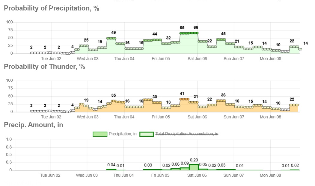
After a brief break in active weather during the final days of May and the start of June, a more unsettled pattern will return, with daily chances for rain and thunderstorms beginning Tuesday.
A weak disturbance over the northern Gulf Coast will move westward, helping to push sea-breeze showers and thunderstorms into the region. Meanwhile, a stalled frontal boundary across North Texas continues to promote persistent south to southeasterly flow, steadily increasing moisture levels and priming the atmosphere for locally heavy rainfall. Tropical-like downpours are the primary concern, though gusty winds up to 40 mph are possible.
Temperatures on Tuesday will climb into the upper 80s and low 90s, but as rain chances increase, afternoon highs will cool slightly due to increased cloud cover and more widespread storm activity. By later in the week, high temperatures will settle about 5 degrees cooler, into the mid- to upper 80s.
“Wednesday continues the stretch of active weather with daily rain and storm chances through the end of the week,” meteorologists at the Austin and San Antonio National Weather Service wrote in their forecast discussion Monday. “This time, it’ll be more due to the increased southwesterly flow aloft and weak disturbances each day bringing the threat for continued beneficial rainfall.”
By Thursday and Friday, an upper-level low over Baja California will lift north and head east, bringing several rounds of rain to Texas with totals nearing 1 inch.