
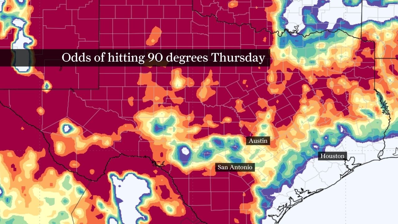
This forecast map shows the probability of reaching at least 90 degrees Thursday across Texas. Odds are highest across West Texas and much of the Hill Country, while probabilities drop across parts of Southeast Texas where cloud cover and lingering rain chances may help keep temperatures below 90.
WeatherBELL
Forecast guidance shows virtually no chance of 100-degree temperatures reaching the Austin area on Thursday. While triple-digit heat may develop across parts of West Texas, Central Texas is expected to remain several degrees cooler, suggesting Austin will likely have to wait longer for its first 100-degree day of 2026.
WeatherBELL
Austin’s rainy stretch is ending just as summer’s first serious heat arrives.

After weeks of thunderstorms and frequent rain chances across Central Texas, a quieter weather pattern is settling in for the week ahead. Rain chances will become increasingly limited while temperatures gradually climb, pushing afternoon heat index values into the triple digits and bringing Austin closer to its first 100-degree day of 2026.
Article continues below this ad
The shift comes after an unusually wet start to June. Austin’s official climate site at Camp Mabry has recorded 2.62 inches of rain through the first six days of the month, more than 1.5 inches above normal. For perspective, Austin typically receives just 3.68 inches of rain during the entire month of June.
Afternoons heat up in Austin as sunny skies return
A strengthening area of high pressure over the southern United States will become the dominant weather feature across Central Texas this week, leading to fewer storms and a steady warming trend.
WEEKLY OUTLOOK: Sunshine and heat return this week in Central Texas. How hot will it get?
Article continues below this ad
While an isolated afternoon shower or thunderstorm can’t be completely ruled out Monday — particularly east of Interstate 35 where sea breeze activity may develop — most of the Austin area is expected to remain dry through the workweek.
A few storms may develop Monday afternoon, especially along and east of the Interstate 35 corridor.
Pivotal Weather
Afternoon highs will climb through the low and mid-90s during the first half of the week before approaching the upper 90s by Friday and next weekend. Humidity levels will remain elevated, causing heat index values to regularly reach the upper 90s and low 100s during the hottest part of the day.
Article continues below this ad
The pattern marks a notable change from the wet weather that dominated much of May and early June, but it is also a more typical setup for June in Central Texas as summer begins to take hold.
Warm nights offer little relief
The heat won’t just be felt during the afternoon.
Low temperatures are expected to remain in the low to mid-70s throughout the week, limiting overnight cooling across the Austin area. While those temperatures may not seem particularly extreme, they can make a noticeable difference after several consecutive days of hot and humid weather.
Article continues below this ad
JUNE RAIN: Storm chances return to Austin this week. Could June end up wetter than normal?
Warm nights prevent homes and buildings from fully releasing the heat accumulated during the day, making mornings feel muggy and allowing heat stress to build over time. That’s one reason heat risk levels are expected to increase later this week even if afternoon temperatures remain just below 100 degrees.
The combination of warm mornings, humid afternoons and temperatures pushing into the upper 90s could make it harder for some people to recover from the day’s heat, especially those spending extended periods outdoors.
Will Austin hit 100 degrees for the first time?
It’s certainly possible by the end of the week.
Article continues below this ad
Forecast highs are expected to reach the upper 90s by Friday and Saturday. If temperatures end up running just a degree or two warmer than currently projected, parts of the Austin area could record their first 100-degree day of 2026.
Recent history shows there’s a wide range for when Austin typically reaches the century mark. Over the past nine years, the first 100-degree day has arrived as early as May 13 in 2025 and as late as July 14 in 2019.
This chart shows forecast temperatures at Austin-Bergstrom International Airport through next Wednesday. While temperatures over the next ten days will remain warm, the chance of triple digit heat is low.
WeatherBELL
Last year, Austin’s first 100-degree day occurred on June 27. In 2023, the milestone arrived on June 9, while 2022 reached 100 degrees even earlier on May 21.
Article continues below this ad
For now, forecast guidance keeps temperatures just below that threshold through most of the week, but the margin is small. Whether Austin officially reaches triple digits or not, afternoons will feel hot. Heat index values near or above 100 degrees are expected, making hydration and frequent breaks increasingly important for anyone spending time outdoors.