
Summer heat is building across South Texas. High atmospheric pressure has developed over the state, and it has led to temperatures in the lower 90s with humidity-driven heat index values topping 100 degrees at times. The hot and humid weather is expected to stick around through much of the week.
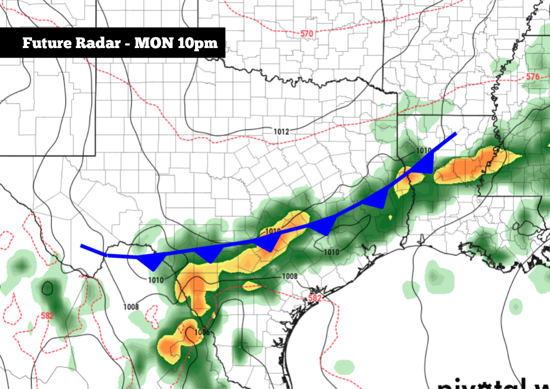
However, weather models are hinting at a shift in the weather pattern by the weekend and especially into early next week. Rain chances are expected to increase, and a weak summertime cold front might even push through the region as well. Here’s a breakdown of how the upcoming week is likely to shake out.
A mild and very humid morning is expected across South Texas as temperatures likely hover in the mid- to upper 70s between 6 a.m. and 9 a.m. Temperatures will rise gradually, likely reaching the mid- to upper 80s by noon.
Mostly cloudy skies are also expected early on, but by the afternoon, partly sunny skies are likely throughout the region. The off-and-on sunshine will allow high temperatures to reach about 92 degrees by 5 p.m – near average for June 10. Very high humidity levels, however, will push heat index values to around 102 degrees.
With plenty of atmospheric moisture in place, a few scattered showers and weak storms are possible. However, the high atmospheric pressure overhead will limit rain chances to just 10% to 20%. Most areas will stay dry and, for the regions that do experience rainfall, it will likely be quite brief.
Temperatures will stay very warm throughout much of the evening, only retreating into the upper 80s after 8 p.m. Overnight lows will stay mild, settling into the mid- to upper 70s once again.
Heat continues: No significant forecast changes are anticipated Thursday or Friday, as temperatures will continue to top out at 92 to 93 degrees, with triple-digit heat index values also continuing. Isolated showers and weak storms will also stay in the forecast, but with only a 20% chance of rain each day.
Forecast models show that high pressure will likely weaken slightly over the weekend, which might bring a few more showers and storms into the region. San Antonio rain chances will be between 20% and 30% both Saturday and Sunday. However, this activity is still expected to be quite spotty, and any rainfall is not expected to last long.
Weekend temperatures will stay hot, with highs expected to rise into the lower to mid-90s while morning temps stay consistently in the upper 70s.
Larger forecast changes are possible early next week, especially on Monday and Tuesday, as a potential summertime cold front sweeps into the state. While the front is only expected to lower temperatures by a few degrees, the larger effect will be on rain chances.
San Antonio currently has about a 40% to 50% chance of rain Monday and Tuesday, and some storms could be strong, capable of lightning, strong winds, and isolated flooding. The exact timing for these storms is still unclear, so be sure to stay with exressnews.com/weather for more forecast details in the coming days.