
After several weeks of active weather and the constant threat of thunderstorms, the weather pattern over South-Central Texas has finally calmed down over the past couple of days, as high atmospheric pressure developed across the region.
However, high pressure will weaken slightly over the next few days, leading to slight rain chances in South Texas Friday and into the weekend. After that, more significant storm chances – with the potential of flooding – will be possible by early next week, as a low pressure system brings a summer cold front into the Lone Star State. Here’s a day-by-day breakdown of what to expect in San Antonio.
Friday morning will be similar to what San Antonio has experienced over the past few days, with low temperatures hovering in the upper 70s under mostly cloudy skies. Temperatures will rise steadily throughout the day, reaching the mid-80s at noon before topping out in the lower 90s by the late afternoon.
Extremely high humidity levels will continue to play a big factor, resulting in “feels like” temperatures rising to between 100 and 103 degrees during the afternoon. Winds won’t provide much of a breeze, coming in from the southeast at 5 to 10 mph.
A few isolated showers and weak storms are also possible through the middle of the day. However, rain coverage across South-Central Texas will only be around 20%, meaning that the majority of the region will stay dry.
Saturday: Nearly identical weather is expected in San Antonio on Saturday. Morning temps in the upper 70s will transition into the lower 90s by the afternoon with high humidity still in place. We have a shot at a brief afternoon shower, but rain chances are just 20%.
Sunday: Rain chances are expected to increase slightly on Sunday, as high pressure weakens and more moisture moves north from the Gulf of Mexico. San Antonio will have about a 30% to 40% chance of rainfall, with isolated heavy downpours and strong winds possible. High temperatures will stay in the lower 90s.
On Monday, a weak cold front is expected to slide through Texas, and as it interacts with deep Gulf moisture. It will provide more widespread showers and thunderstorms. San Antonio rain chances will increase to around 60%, with a good chance of continued showers and storms on Tuesday as well.
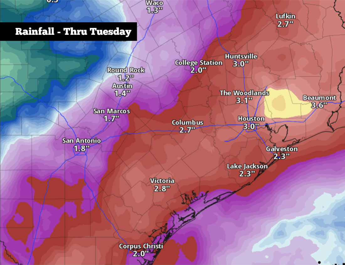
Some storms could be slow-moving and capable of intense rainfall rates. For those reasons, isolated flash flooding will be possible across parts of South-Central Texas. The National Weather Service’s Weather Prediction Center has placed a low-end level 1 of 4 risk of flash flooding on San Antonio on Monday, with a higher level 2 threat in areas to the east, including Houston and Beaumont.
According to the National Blend of Models, about an inch to 2 inches of rainfall is anticipated for the San Antonio metro area through Tuesday. However, isolated higher totals of greater than 4 inches could become possible, especially to the east of the city.
Temperatures will also drop slightly behind the weak cold front. Highs on Monday will likely top out in the upper 80s, falling a few more degrees by Tuesday. Temperatures will likely rebound, though, rising back into the 90s by the second half of the week.