
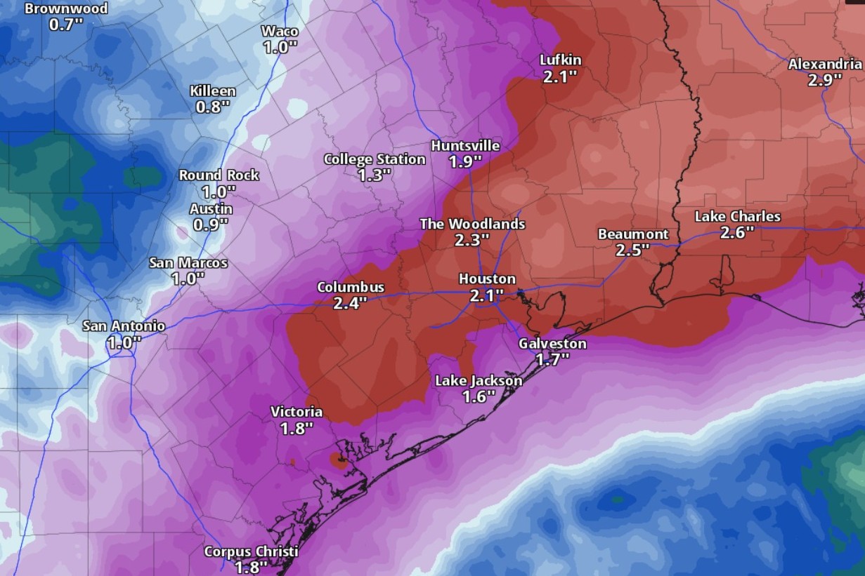
Houston could receive up to 2 inches of rainfall through Tuesday, as a cold front arrives early next week, according to the National Blend of Models, a composite weather forecast model.
National Blend of Models/Pivotal Weather
A major shift in Houston’s weather pattern is underway as a weekend of summertime heat gives way to a growing threat of heavy rainfall and flooding beginning Monday.
Deep tropical moisture from the Gulf of Mexico is expected to spread into Southeast Texas early next week, bringing the potential for several rounds of heavy rainfall. Forecast guidance has become increasingly consistent in showing a wetter pattern that could create flooding concerns across Southeast Texas.
The bottom line for Houston weather:
Article continues below this ad
Humidity-driven heat index values above 105 degrees (41 degrees Celsius) are possible this weekend, while rip current risk increases along the upper Texas Coast.
Heavy rainfall could begin Monday as tropical moisture spreads into Southeast Texas.
Flooding is becoming a greater concern across Southeast Texas next week.
Weekend outlook includes heat and rip current danger
Saturday and Sunday will bring partly sunny skies, hot temperatures and elevated humidity across Southeast Texas. Afternoon highs are expected to reach the upper 90s inland, with heat index values possibly exceeding 105 degrees during the hottest part of the day.
None of this is unusual for Houston in June, but this will be one of the first widespread stretches of triple-digit heat index values this year. Heat remains the leading weather-related cause of death in the United States, making it a hazard worth taking seriously even in a city accustomed to summer weather.
Article continues below this ad
The timing matters with thousands of people expected outdoors for Houston’s FIFA Fan Fest and other weekend events. Anyone spending several hours outside should drink water regularly, wear lightweight clothing, use sunscreen and take frequent breaks in shaded or air-conditioned areas. Older adults, children, people with chronic health problems and outdoor workers will face a higher risk of heat-related illness.
The heat will not be the only weekend hazard. Strengthening onshore winds could increase the risk of dangerous rip currents along the upper Texas Gulf Coast. Anyone heading to the beach should swim near lifeguards when possible and avoid entering the water alone.
Heavy rain and flood risk increase early next week
The shift begins early next week as deep Gulf moisture surges northward into Southeast Texas.
Article continues below this ad
That moisture is expected to come from a broad area of potential tropical development in the Gulf of Mexico. Don’t expect this atmospheric disturbance to become Arthur, the first named storm of the 2026 Atlantic hurricane season. For Southeast Texas, though, the bigger issue is not whether the system earns a name, but how much tropical moisture it sends into the region.
Flood forecasters at the Weather Prediction Center have placed large parts of Southeast Texas under a level 2 of 4 risk, or at least a 15% chance, of flooding rainfall Sunday night and into Monday.
Weather Prediction Center/National Weather Service
Rain chances are expected to increase Monday and Tuesday, with periods of heavy rainfall possible for several days. Tropical air masses can produce very high rainfall rates, meaning street flooding and areas with poor drainage getting overwhelmed quickly if heavy downpours repeatedly hit the same areas.
Confidence in the flood threat has increased enough that the Weather Prediction Center has placed much of Houston and Southeast Texas under a level 2 of 4 risk, or at least a 15% chance, of flooding rainfall Monday. This designation suggests scattered flash flooding is possible if repeated rounds of heavy rain develop, particularly in urban areas where runoff accumulates quickly.
Article continues below this ad
Rainfall totals remain uncertain, and small changes in the Gulf disturbance could shift where the heaviest rainfall sets up. Still, confidence is increasing that the region is headed into a wetter and more flood-prone pattern beginning early next week.
Residents should use the rest of the weekend to clear drains where possible, review flood plans and avoid driving through flooded roads if heavy rainfall develops next week.