
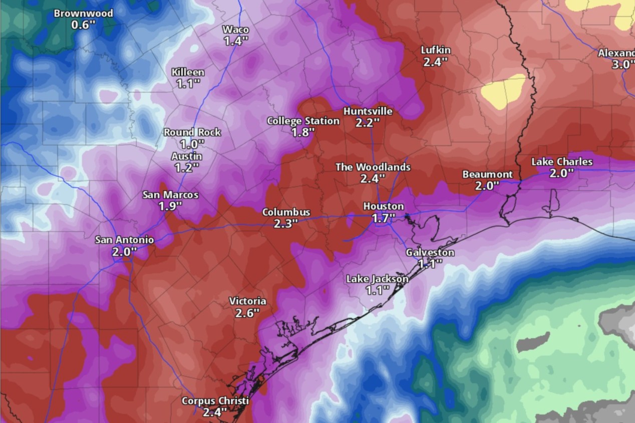
Rainfall totals of at least an inch are possible in Austin through Tuesday, according to the National Blend of Models, a composite weather forecast model.
National Blend of Models/Pivotal Weather
The first half of June in Austin has been dominated by short but disruptive bursts of rainfall, followed by days of steamy, sticky weather. The presence of high atmospheric pressure has meant we’ve had hotter air that also has been extra humid because of all the evaporating moisture.

However, the National Weather Service and the National Hurricane Center are watching for certain developments that could shake up Texas weather over the next 48 hours: the weakening effects of the high pressure system, the arrival of a rare summer cold front, and the influence of a tropical disturbance in the Gulf of Mexico.
Article continues below this ad
Sunday’s forecast
Thanks to abundant atmospheric moisture in South and Central Texas, streamer showers from the Gulf Coast have been forming along and east of the Interstate 35 corridor with the heating of day, producing a quick quarter-inch to a half-inch of rainfall, the weather service said.
“Sunday, we could see more of the same — however, we could see more widespread activity as even higher moisture moves off the Gulf and across the area,” the weather service wrote in a forecast bulletin Saturday.
Austin on Sunday has a 50% chance of afternoon rain, and the elevated humidity means that a peak daytime temperature of 93 degrees could feel as hot as 105. Forecasters anticipated new rainfall amounts of less than a tenth of an inch, but “any streamer showers and storms will be capable of producing a quick inch of rain in any of the heavier cells.”
Article continues below this ad
Sunday night, Austin’s rain chances ramp up to 70%.
Humidity-driven heat index values, or “feels like” temperatures, will be in the triple digits in Austin by 3 p.m. Sunday, according the National Blend of Models, a composite weather forecast model.
National Blend of Models/Pivotal Weather
Gulf disturbance creeps toward Texas
“Moisture levels continue to increase even further by early next week as a disturbance currently located over the Bay of Campeche is expected to move northward into either northern Mexico or the southern Texas coast,” the weather service said.
Article continues below this ad
Global weather forecast models are split on how the atmospheric disturbance in the Gulf will affect Texas weather, according to forecasters:
In one modeling outcome, the disturbance moves into the mountains of northern Mexico and dissipates, which would reduce the threat of heavy rainfall in Texas.
In the second outcome, the disturbance moves northward and “becomes trapped in weak steering flow, allowing for multiple rounds of showers and storms across our area and southern Texas and heavier rainfall.
Monday cold front
Complicating the forecast is the arrival Monday of a rare June cold front, which is likely to bring even more rain chances to Austin and a significant dip in temperatures.
Article continues below this ad
Flood forecasters at the Weather Prediction Center have placed large parts of South and Central Texas under a low-end level 1 of 4 risk, or at least a 5% chance, of flooding rainfall Sunday.
Weather Prediction Center/National Weather Service
Rain is all but certain in Austin on Monday, as forecasters give the city a 90% chance of showers and possibly a thunderstorm. However, afternoon temperatures will be several degrees lower than the previous day and rain-cooled air should keep temps below 86. At night, rain chances ease to 60%.
“Due to the increased moisture across the area we could see a risk for instances of flash flooding as any of the storms would be capable of producing torrential rainfall,” the weather service said.
The weather service’s flood forecasters at the Weather Prediction Center have placed large parts of Central Texas under a low-end level 1 of 4 risk, or at least a 5% chance, of flooding rainfall Sunday night and into Monday.
Article continues below this ad
“Moisture continues to remain across the area as do showers and storms going into Tuesday with WPC again keeping our area along and east of the I-35 Corridor in a level 1 of 4 risk for excessive rainfall,” the weather service said in its forecast bulletin, “as it’s possible the aforementioned disturbance may remain just close enough to impact the eastern half of our area.”
Tuesday and beyond
Austin on Tuesday has only a 40% chance of rain, and that’s mainly before 1 p.m., forecasters said. Overcast skies will help keep temperatures limited to the upper 80s.
Article continues below this ad
“Beyond Tuesday, things continue to remain uncertain as the aforementioned disturbance over Mexico and its remnants will have a big impact on if we continue seeing more rainfall or a drier solution leading to more heat across the area,” the weather service said.
Forecasters warned that “we could see temperatures approach the upper 90s to near triple digits across the area. Add in the abundant moisture across our region and we could be looking at heat indices near or even above 110 degrees,” which would trigger heat alerts from the weather service.