
A low-pressure system brings tropical possibilities to the Texas coast | Tracking the tropics
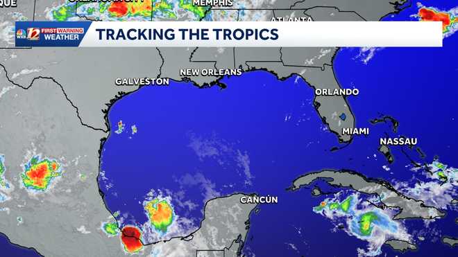
There is potential for a tropical disturbance to form in the Gulf later this week.
FINAL RUN. EXCITING STUFF. DAVE, DO YOU THINK WE CAN GET SOME OF THAT BACK IN THE WEATHER CENTER OVER THERE? I’LL TAKE SOME OF THE ICE BACK THERE. OH, ABSOLUTELY. YEAH. THAT WOULD FEEL REALLY, REALLY NICE. I MEAN, THE ONLY PEOPLE I’M JEALOUS OF ARE THE FOLKS WHO ARE IN LAS VEGAS AT THAT HOCKEY RINK AND THOSE AT MYRTLE BEACH OVER THERE. YEAH, I KNOW A FEW FOLKS ENJOYING THE SUNRISE DOWN AT MYRTLE BEACH AT THE MOMENT. THE SUN STARTING TO COME UP RIGHT NOW DOWN ALONG THE COAST OF BAR HARBOR RESORT. CAMS.COM. BRINGING THIS TO YOU, AND I’M SURE FOLKS WILL BE OUT THERE A LITTLE BIT LATER ON AS WE GO INTO THE LATTER PART OF THE AFTERNOON. GET OUT THERE, MAYBE GET IN THE WATER A LITTLE BIT. WE’RE BEACH WATER TEMPERATURES ARE INTO THE 70S FOR THE MOST PART. AIR TEMPERATURES 78 HATTERAS AND DOWN AROUND ATLANTIC BEACH TO 78 WILMINGTON 7781. DOWN AROUND HOLDEN BEECH AND OAK ISLAND. MYRTLE BEACH AT 78. AT THE MOMENT, YOU GO INLAND A LITTLE BIT MORE, IT’S A LITTLE BIT HOTTER IN SOME OF THOSE AREAS. THAT WILL BE THE CASE LATER THIS AFTERNOON TOO. BUT IF YOU GO DOWN TO THE BEACHES, MOSTLY SUNNY ALONG THE OUTER BANKS, 86, AROUND 91 AND A CHANCE FOR SOME SCATTERED SHOWERS AND THUNDERSTORMS DOWN AROUND WRIGHTSVILLE, MYRTLE BEACH LATER ON THIS AFTERNOON TOO. WE’RE TRACKING THE TROPICS. NOT MUCH GOING ON IN THE CARIBBEAN. NOT REALLY MUCH GOING ON IN THE GULF EITHER. THERE IS THIS ONE BROAD AREA OF LOW PRESSURE THAT’S RIGHT ALONG THE COAST OF MEXICO, PRODUCING SOME SHOWERS AND THUNDERSTORMS, BUT THEY’RE PRETTY SMALL. WE’RE GOING TO WATCH THIS AREA AS IT MOVES BACK OUT, POSSIBLY INTO THE NORTHWEST GULF. BY THE TIME WE GET INTO ABOUT TUESDAY OR MID WEEK OR SO, AND IT HAS ABOUT A 20% CHANCE OF DEVELOPING THROUGH THAT TIME. THE PROBLEM IS IT’S SO CLOSE TO LAND IT MAY NOT SEE MUCH DEVELOPMENT, BUT WE’LL WATCH IT WITH YOU OVER THE NEXT COUPLE OF DAYS. THAT’S ABOUT ALL THAT’S GOING ON OUT IN THE TROPICS AT THE MOMENT. 72 GREENSBORO RIGHT NOW, 68 IN BURLINGTON AND WINSTON-SALEM, 64 WILKESBORO AND SOME COMFORTABLE 50S BACK OUT IN THE MOUNTAIN COUNTIES AT THIS HOUR. DEW POINT TEMPERATURES, NOT BAD IN THE MOUNTAINS AT THE MOMENT. WE’RE INTO THE LOW AND MID 60S ACROSS PIEDMONT, UPPER 60S THE FURTHER SOUTH YOU GO. SO IT’S A LITTLE BIT MUGGIER. THE FURTHER SOUTH AND EAST YOU GO TO HIGH TEMPERATURE YESTERDAY WAS 93 ACROSS THE REGION. OUR RECORD FOR YESTERDAY WAS 103 SET 1914. SO WE’RE A WAYS FROM THAT. OUR AVERAGE HIGH THIS TIME OF YEAR 85. THAT 93, BY THE WAY, WAS OUR SIXTH DAY FOR THE MONTH OF JUNE. WE’VE BEEN INTO THE 90S AND TODAY WILL BE THE SEVENTH. AND THAT’S OUR AVERAGE FOR 90 DEGREE DAYS IN JUNE IS ABOUT SEVEN. SO WE MAY ECLIPSE THAT WITH HALF THE MONTH STILL TO GO. NO RAINFALL IN THE RAIN GAUGE. WE’RE 7.5IN BELOW AVERAGE FOR THE YEAR. AND THAT ATTESTS FOR THE DROUGHT THAT’S OUT THERE AT THE MOMENT. AND THAT WILL CONTINUE WITH TIME. WE’LL GET A DROUGHT UPDATE ON THURSDAY WHERE WE HAVE SOME AREAS IN EXCEPTIONAL DROUGHT ACROSS THE REGION. FIRST DAY OF SUMMER IS COMING UP ON SUNDAY, JUNE 21ST. SO THAT’S WHAT’S NEXT SUNDAY, ISN’T IT? WE’VE GOT 14 HOURS AND 36 MINUTES OF DAYLIGHT AS WE GET INTO NEXT WEEK AND SUNRISE AT 602 ON SUNDAY, AND THEN 639 IN THE OR 839 AS WE GO INTO THE EVENING, YOU CAN SEE NOT MUCH IN THE WAY OF RADAR ACTIVITY OUT HERE. FEW CLOUDS. THAT’S ABOUT IT. THERE ARE SOME STORMS BACK OUT TO THE WEST OVER MISSOURI AND ARKANSAS. THEY’VE HAD SOME FLOODING ISSUES BACK THERE, AND WE’LL WATCH THAT WITH INTEREST AS WE GO ON INTO THIS AFTERNOON. WE ARE IN THIS LEVEL TWO SLIGHT RISK FOR SEVERE THUNDERSTORMS THAT MAY OCCUR A LITTLE BIT LATER ON TODAY. THE PRIMARILY THE PRIMARY COMPONENT OF THAT WOULD BE SOME DAMAGING WINDS THAT COULD EXIST. THERE’S A DECENT CHANCE IF WE DO SEE A SCATTERED STORM TO DEVELOP, TO BLOW UP AND HAVE SOME WINDS IN EXCESS OF 60MPH AND MAYBE A LITTLE SMALL HAIL OUT THERE AS WELL. IF YOU GET CAUGHT UNDERNEATH THOSE, THERE’S SO MUCH HUMIDITY IN THE ATMOSPHERE, IT DUMPS A LOT OF RAIN. THIS IS ABOUT 2:00. YOU CAN SEE SOME OF THESE SHOWERS AND STORMS STARTING TO DEVELOP BACK OUT OVER THE MOUNTAIN COUNTIES. AS WE GET ON INTO LATER IN THE AFTERNOON ACROSS THE WESTERN PIEDMONT AND THE FOOTHILLS. AND THEN WE’LL SEE THOSE STORMS KIND OF PUSH THEIR WAY ON DOWN TO THE EAST. WE’LL SEE EXACTLY WHERE THESE HIT AS WE GO THROUGH LATER IN THE DAY. THEN AS WE GET ON INTO THE EVENING, STILL A CHANCE FOR AN ISOLATED SHOWER OR THUNDERSTORM. AND THEN AS WE GET ON INTO TOMORROW, TEMPERATURES WILL BE A LITTLE BETTER, WILL BE A LITTLE DRIER, AND HIGH TEMPERATURES INTO THE MID 80S FOR YOUR MONDAY AFTERNOON. HERE’S OUR TROUGH THAT’S OUT HERE. THAT’S GOING TO BE THE FIRING LINE. THIS FRONT WILL WASH OUT. AND THEN THIS COLD FRONT WILL MOVE THROUGH AS WE GO ON INTO THE OVERNIGHT TONIGHT. THAT WILL BRING IN SOME DRIER AIR FOR THE NEXT COUPLE OF DAYS OR SO. TEMPERATURES MUCH COOLER BACK OUT OVER THE PLAINS STATES RIGHT NOW. TODAY’S FORECAST. WE’RE GOING TO GO HOT AGAIN LOW TO MID 90S FOOTHILLS. PIEDMONT. THE SEVERE STORM RISK ALSO INTO THE MOUNTAINS AND HIGH TEMPERATURES THERE WILL BE INTO THE LOW 80S LATER THIS AFTERNOON. MONDAY AND TUESDAY LOOK GREAT. LOW TO MID 80S BOTH DAYS AND DRY. WE WARM UP ON WEDNESDAY AND THE NEXT BEST CHANCE FOR SHOWERS AND STORMS WILL BE L
A low-pressure system brings tropical possibilities to the Texas coast | Tracking the tropics
There is potential for a tropical disturbance to form in the Gulf later this week.

Updated: 7:35 AM EDT Jun 14, 2026
The last named tropical system was Hurricane Melissa in 2025; the storm reached a Category 5 on the Saffir-Simpson Hurricane Wind Scale, with wind speeds of 190 miles per hour, just off the coast of Jamaica before weakening on October 31. This year’s first tropical system will be named Arthur, but it might be a while before we get an official named system this hurricane season.2026 Atlantic hurricane season storm names The list includes 21 potential storm names that are chosen by the World Meteorological Association naming committee. This week’s tropical area of interest is in the GulfThere is currently a slight chance of tropical development in the Gulf from a broad area of low pressure that formed the second week of June off of Mexico’s northeastern coastline. While the low pressure is currently a disorganized area of disturbed weather, rain and thunderstorms may begin impacting parts of Texas from Brownsville to Corpus Christi within the next few days. And while the area of disturbed weather may briefly move inland over northern Mexico, tropical forecast models show a reemergence of the system over the Gulf on Tuesday or Wednesday. Right now, there is a low chance of development within the next seven days. It is an area to monitor, as conditions may change once a front becomes stationary over the Deep South later this week.Gulf: Latest tropical development potential Gulf: Low pressure may bring rain to Texas coast You can find more information on the tropical weather outlook from the National Hurricane Center here in English or here in Spanish. Gulf: Infrared satellite imageryThis year, the climate pattern known as El Niño is expected to suppress tropical systems in the Atlantic Ocean Basin. Although a slightly less active season is possible, there is no guarantee a direct North Carolina impact won’t happen. Residents know to be prepared for any coastal storm, whether it becomes tropical or whether it originates on another coast. Inland flooding and coastal storm surge are still possible even when a non-tropical system approaches North Carolina. Find out more in the story below. More weather coverage: Weather Alerts | Latest weather forecast | Post pictures to the uLocal North Carolina Facebook Group | Traffic information | Report closings and delays | SkyCams | Download the WXII12 News mobile app
WINSTON-SALEM, N.C. —
The last named tropical system was Hurricane Melissa in 2025; the storm reached a Category 5 on the Saffir-Simpson Hurricane Wind Scale, with wind speeds of 190 miles per hour, just off the coast of Jamaica before weakening on October 31. This year’s first tropical system will be named Arthur, but it might be a while before we get an official named system this hurricane season.
2026 Atlantic hurricane season storm names
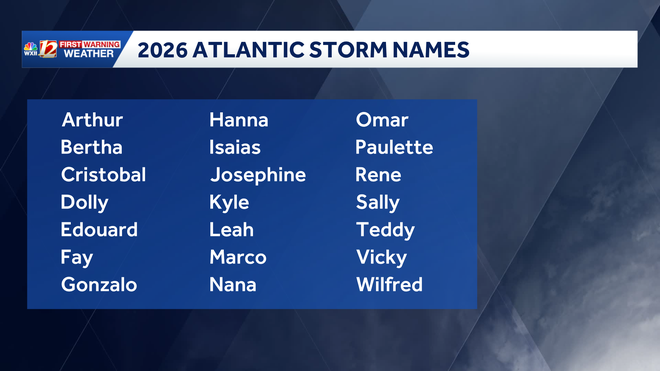
The list includes 21 potential storm names that are chosen by the World Meteorological Association naming committee.
This week’s tropical area of interest is in the Gulf
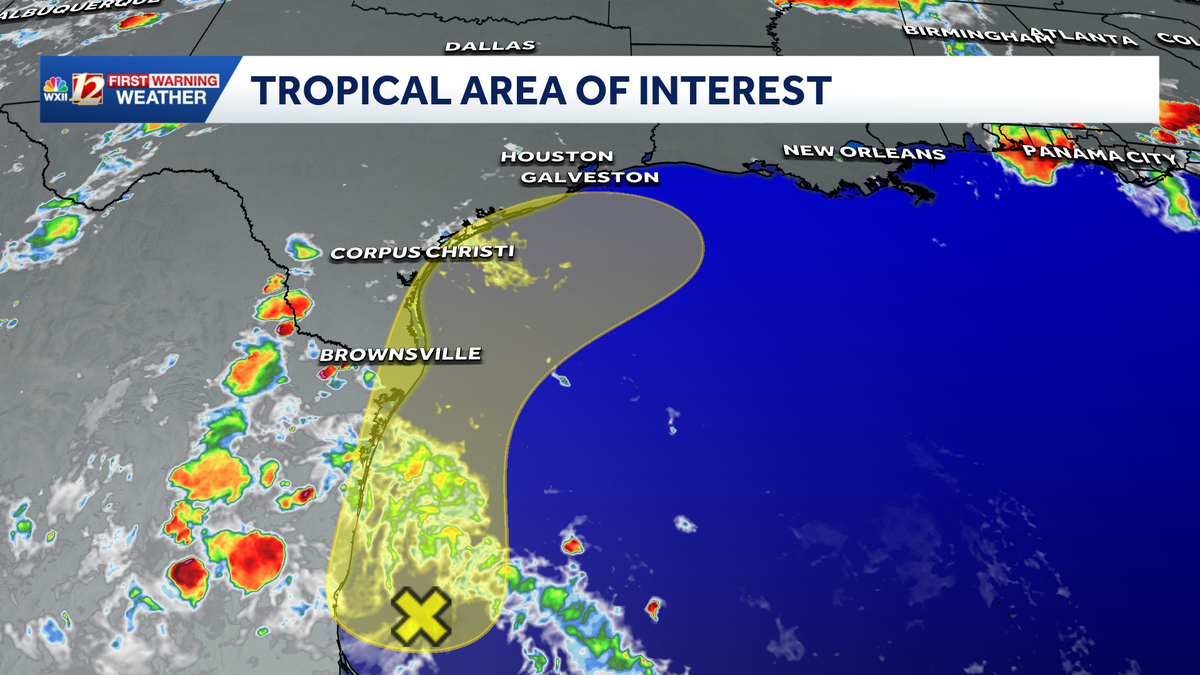
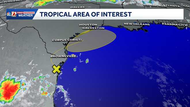
There is currently a slight chance of tropical development in the Gulf from a broad area of low pressure that formed the second week of June off of Mexico’s northeastern coastline. While the low pressure is currently a disorganized area of disturbed weather, rain and thunderstorms may begin impacting parts of Texas from Brownsville to Corpus Christi within the next few days. And while the area of disturbed weather may briefly move inland over northern Mexico, tropical forecast models show a reemergence of the system over the Gulf on Tuesday or Wednesday.
Right now, there is a low chance of development within the next seven days. It is an area to monitor, as conditions may change once a front becomes stationary over the Deep South later this week.
Gulf: Latest tropical development potential
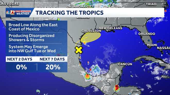
Gulf: Low pressure may bring rain to Texas coast
You can find more information on the tropical weather outlook from the National Hurricane Center here in English or here in Spanish.
Gulf: Infrared satellite imagery
This year, the climate pattern known as El Niño is expected to suppress tropical systems in the Atlantic Ocean Basin. Although a slightly less active season is possible, there is no guarantee a direct North Carolina impact won’t happen. Residents know to be prepared for any coastal storm, whether it becomes tropical or whether it originates on another coast. Inland flooding and coastal storm surge are still possible even when a non-tropical system approaches North Carolina. Find out more in the story below.
1 of 6
Tracking the Tropics: Potential areas of tropical development within the next seven days.
2 of 6
Current area of interest for potential tropical development.
3 of 6
Gulf: Infrared Satellite Imagery
4 of 6
This image shows estimated wave heights and current ocean buoy data.
5 of 6
2026 Atlantic Storm Names
This chart shows the 2026 Atlantic storm names.
6 of 6
Tropical Systems Based on Wind Categories (MPH)
This chart shows the level of wind speeds in miles per hour that are needed to be categorized as a tropical system.
More weather coverage: Weather Alerts | Latest weather forecast | Post pictures to the uLocal North Carolina Facebook Group | Traffic information | Report closings and delays | SkyCams | Download the WXII12 News mobile app