
A flood watch goes into effect for the Austin area Sunday at 7 p.m. and will last through Tuesday evening.
NOAA’s National Weather Service
Austin and much of Central Texas will be under a flood watch beginning at 7 p.m. Sunday as rounds of heavy rain threaten to bring flash flooding through Tuesday evening.

The greatest concern is the potential for training thunderstorms — storms that repeatedly move over the same locations — which could quickly overwhelm creeks, streams, low-water crossings and other flood-prone areas.
Article continues below this ad
Why is a flood watch in effect for Austin and Central Texas?
Very humid tropical air moving into the region will interact with a stalled frontal boundary, creating conditions favorable for repeated rounds of heavy rain through Tuesday.
TEXAS-INSPIRED: How Central Texas floods inspired the ‘Turn Around, Don’t Drown’ weather safety slogan.
The National Weather Service issues a flood watch when conditions are favorable for flooding, but flooding is not yet occurring.
Article continues below this ad
How much rain could Central Texas receive?
Rainfall rates could exceed 2 to 3 inches per hour at times, particularly during stronger thunderstorms.
Rainfall totals of 2 to 3 inches will be common across Central Texas, including Austin, through Tuesday. Localized pockets of up to 8 inches are possible, especially east of Interstate 35.
NOAA’s Weather Prediction Center / Pivotal Weather
While rainfall amounts will vary considerably by location, isolated areas could receive 8 inches of rain or more before the event ends Tuesday evening.
Article continues below this ad
Which counties are included in the flood watch?
The flood watch covers Travis and Williamson counties, along with Bastrop, Blanco, Burnet, Caldwell, Hays and dozens of other counties across South Central Texas.
Major cities included in the watch area are Austin, Round Rock, Georgetown, San Marcos, New Braunfels and San Antonio.
Article continues below this ad
What are the flooding risks?
The greatest concern is flash flooding in low-lying and flood-prone areas.
Excessive runoff could cause rivers, creeks and streams to rise rapidly and their banks to potentially overflow. Low-water crossings may become impassable, especially during periods of intense rainfall.
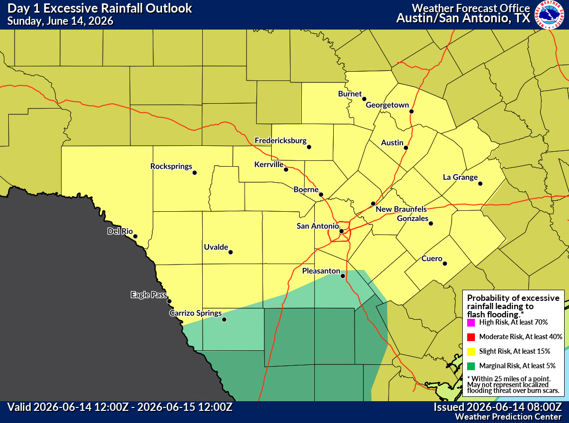
Sunday’s flood outlook is shown across Central Texas.
NOAA’s Weather Prediction Center
The flood outlook peaks across the Austin area on Monday.
NOAA’s Weather Prediction Center
As a sluggish frontal boundary begins pushing south through Tuesday, the highest risk of flooding will push south of Austin.
NOAA’s Weather Prediction Center
Wednesday’s flood risk will be found well to the south and east of Austin.
NOAA’s Weather Prediction Center
By Thursday, the return of tropical downpours could bring isolated flooding back to the Austin area.
NOAA’s Weather Prediction Center
Life-threatening flooding is possible somewhere within the watch area if the heaviest rain bands repeatedly affect the same locations.
Article continues below this ad
When will the heaviest rain occur?
The flood watch begins at 7 p.m. Sunday and remains in effect through Tuesday evening.
FIRST SUMMER DAYS: When is the first day of summer? In Austin, you can get 5 different answers.
Periods of heavy rain are expected overnight Sunday into Monday and again through Tuesday as the combination of deep tropical moisture and a stalled front supports multiple rounds of thunderstorms across the region.
Article continues below this ad
What should Austin-area residents do?
Residents should closely monitor forecasts and be prepared to act if flash flood warnings are issued.
Drivers should never attempt to cross flooded roadways. Water can rise quickly during heavy downpours, and even shallow flooding can sweep vehicles away.
Article continues below this ad
Those living near creeks, streams and other flood-prone locations should have a plan in place in case flooding develops overnight or during the day Tuesday.