
A tropical disturbance could bring rain to the Texas coast | Tracking the tropics
There is potential for a tropical disturbance to form in the Gulf later this week.
THE FORECAST, WE ARE COMING OFF A VERY HOT AND HUMID WEEKEND, AND WE HAD SOME STORMS TO MAYBE COOL THINGS DOWN. LANEY. YEAH, WE DEFINITELY HAVE A FEW SHOWERS OUT THERE THAT ARE LEFT OVER. WE ALSO HAVE A COLD FRONT THAT IS HEADING OUR WAY, WHICH MEANS FOR THE EARLY PART OF THE WEEK, IT WILL NOT BE AS HOT OR AS HUMID AS WHAT WE HAVE SEEN. NOW WE WILL BRING BACK SOME HEAT LATER ON IN THE WEEK. SO KEEP THAT IN MIND. AND WE ALSO HAVE A STORM RISK THAT COMES BACK. TAKE A LOOK. SUNDAY AFTERNOON AT BELEWS LAKE OR WINSTON-SALEM YOU CAN SEE THE RAIN CAME IN AND THE LAKE CLEARED OUT A LITTLE BIT. AND THEN WE HAD MORE SUNSHINE AND MADE FOR A BEAUTIFUL EVENING ACROSS THE AREA. LOOK AT THESE HIGH TEMPERATURES WERE 94 IN GREENSBORO TODAY, 91 IN MOCKSVILLE, 96 IN LEXINGTON, 90 IN DANBURY AND WILKESBORO. A LOOK AT OUR HIGH TEMPERATURE ABOUT TEN DEGREES ABOVE NORMAL OUT THERE AND FOUR DEGREES SHY OF A RECORD. NOW WE’RE GOING TO SEE THOSE TEMPERATURES DROP HEADING INTO TOMORROW. HIGH TEMPERATURE ABOUT 85. AND THEN WE’VE GOT LOW 80S FOR TUESDAY. AND THEN WE’RE RIGHT BACK TO NEAR 90 BY THE END OF THE WEEK. SO DEFINITELY WANT TO PLAN TO BE OUTDOORS THE EARLY PART OF THE WEEK. IT’S STILL PRETTY HUMID OUT THERE. RIGHT NOW. IT’S WARM TO 77 IN BURLINGTON, 79 IN MOUNT AIRY. WE’VE GOT 73 IN GALAX, AND WE DO STILL HAVE SOME ACTIVITY ON THE RADAR. WE’RE NOT WORRIED ABOUT SEVERE THUNDERSTORMS ANYMORE ACROSS THE AREA. THANKFULLY, WE GOT BY WITHOUT ANY SEVERE THUNDERSTORM WARNINGS TODAY. WE DID HAVE A COUPLE STRONG STORMS THAT ROLLED THROUGH. AND YOU SAW THOSE TREES DOWN IN GUILFORD COUNTY. NOTICE FROM LEXINGTON DOWN TO SALISBURY, WE DO HAVE SOME RAIN AND IT’S A LITTLE BIT HEAVIER AS YOU GO OUT TO THE WEST ALONG HIGHWAY 64. NO LIGHTNING SHOWING UP JUST YET, BUT THAT’S POSSIBLE. AND THEN YOU DO SEE THAT LINE OF SHOWERS FROM ELK CREEK ALL THE WAY TO JUST WEST OF BOONE, AS WE DO HAVE THAT FRONT COMING THROUGH, WE DID GET SOME MUCH NEEDED RAINFALL, AT LEAST IN SPOTS WHERE WE HAD SOME HEAVIER DOWNPOURS JUST OVER A QUARTER OF AN INCH IN FORSYTH COUNTY, ABOUT A HALF OF AN INCH IN ROCKINGHAM COUNTY, ALL WITHIN THE LAST 24 HOURS. LITTLE RAIN AROUND GUILFORD COUNTY AS WELL AS ALAMANCE, BUT THANKFULLY NO REAL STORM REPORTS REPORTED TO THE WEATHER SERVICE OUT THERE. AND THE SEVERE STORM RISK IS A LITTLE FARTHER TO OUR NORTHEAST. AND THAT’S WHERE WE’VE SEEN MOST OF THE WIND DAMAGE REPORTS. WE HAD JUST A COUPLE HERE AND THERE ACROSS THE CENTRAL AND EASTERN PARTS OF NORTH CAROLINA TODAY. SO FIRST TROUGH WENT THROUGH WITH SOME STRONGER STORMS, SECOND ONE SWINGING IN RIGHT NOW IT’S GOING TO PROVIDE SOME SHOWERS. AND THEN THAT FRONT WILL SNEAK IN A LITTLE LATER ON. BEHIND IT THERE IS SOME COOLER AIR. SO YOU’RE GOING TO SEE HIGHS OR I SHOULD SAY TEMPERATURES THAT ARE AROUND 70. THE HIGHS OUT THERE TODAY IN THE 80S. AND IT’S NOT JUST THE TEMPERATURE BUT THE MOISTURE CONTENT. THERE IS SOME LESS HUMID AIR UP THERE OVER THE OHIO VALLEY. SO WE’LL START TO FEEL SOME OF THAT TOMORROW AND DEFINITELY HEADING INTO TUESDAY. OUR HIGH IS 85. WE’VE GOT A NORTHWEST WIND TOMORROW WHICH WILL HELP TO BRING IN THAT DRIER AIR. IT WILL MAKE IT FEEL PRETTY COMFORTABLE OUT THERE. HIGH OF 83 TOMORROW AFTERNOON IN THE FOOTHILL TOWNS. AND THEN WE SHOULD GET INTO THE LOW 70S WITH MOSTLY SUNNY SKIES IN THE MOUNTAINS. THE WINDS ARE STRONGER OVER THE NEXT COUPLE OF DAYS. YOU’VE GOT SOME BEAUTIFUL WEATHER TO GET OUT MOUNTAINS, FOOTHILLS AND TRIAD. OUR FOOD DRIVE IS ON WEDNESDAY. WE’VE GOT A GOOD FORECAST FOR THAT AS WELL, WITH TEMPERATURES THAT WILL BE IN THE UPPER 80S. WE’RE ALSO TRACKING THE TROPICS HERE, KEEPING AN EYE ON THIS LITTLE AREA. IT’S AN AREA OF LOW PRESSURE. IT’S NOT TROPICAL. THERE’S NO REAL HIGH CHANCE THAT IT WILL BECOME TROPICAL. BUT WE’RE ALWAYS KEEPING YOU UP TO DATE THIS SEASON. HERE’S YOUR SEVEN DAY FORECAST. YOU’VE GOT HIGHS NEAR 90 WEDNESDAY AND THURSDAY. STORM CHANCES RETURNING BY THE END OF THE WEEK. STAY WITH US. WE’LL BE RIG
A tropical disturbance could bring rain to the Texas coast | Tracking the tropics
There is potential for a tropical disturbance to form in the Gulf later this week.

Updated: 4:06 AM EDT Jun 15, 2026
The last named tropical system was Hurricane Melissa in 2025; the storm reached a Category 5 on the Saffir-Simpson Hurricane Wind Scale, with wind speeds of 190 miles per hour, just off the coast of Jamaica before weakening on October 31. This year’s first tropical system will be named Arthur, but it might be a while before we get an official named system this hurricane season.2026 Atlantic hurricane season storm names The list includes 21 potential storm names that are chosen by the World Meteorological Association naming committee. This week’s tropical area of interest is in the GulfThere is currently a slight chance of tropical development in the Gulf from a broad area of low pressure that formed the second week of June off of Mexico’s northeastern coastline. While the low pressure is currently a disorganized area of disturbed weather, rain and thunderstorms may begin impacting parts of Texas from Brownsville to Corpus Christi within the next few days. And while the area of disturbed weather may briefly move inland over northern Mexico, tropical forecast models show a reemergence of the system over the Gulf on Tuesday or Wednesday. Right now, there is a low chance of development within the next seven days. It is an area to monitor, as conditions may change once a front becomes stationary over the Deep South later this week.Gulf: Latest tropical development potential Gulf: Low pressure may bring rain to Texas coast You can find more information on the tropical weather outlook from the National Hurricane Center here in English or here in Spanish. Gulf: Infrared satellite imageryThis year, the climate pattern known as El Niño is expected to suppress tropical systems in the Atlantic Ocean Basin. Although a slightly less active season is possible, there is no guarantee a direct North Carolina impact won’t happen. Residents know to be prepared for any coastal storm, whether it becomes tropical or whether it originates on another coast. Inland flooding and coastal storm surge are still possible even when a non-tropical system approaches North Carolina. Find out more in the story below. More weather coverage: Weather Alerts | Latest weather forecast | Post pictures to the uLocal North Carolina Facebook Group | Traffic information | Report closings and delays | SkyCams | Download the WXII12 News mobile app
The last named tropical system was Hurricane Melissa in 2025; the storm reached a Category 5 on the Saffir-Simpson Hurricane Wind Scale, with wind speeds of 190 miles per hour, just off the coast of Jamaica before weakening on October 31. This year’s first tropical system will be named Arthur, but it might be a while before we get an official named system this hurricane season.
2026 Atlantic hurricane season storm names
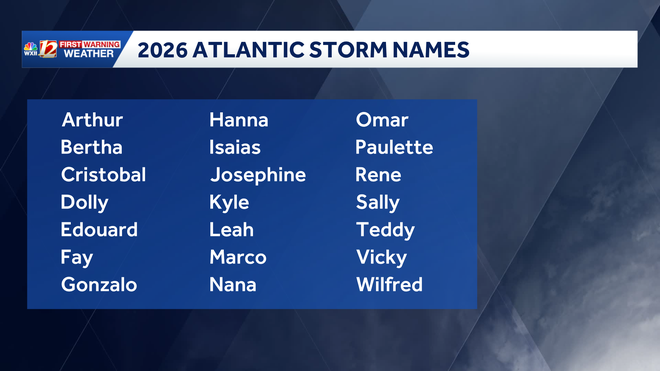
The list includes 21 potential storm names that are chosen by the World Meteorological Association naming committee.
This week’s tropical area of interest is in the Gulf
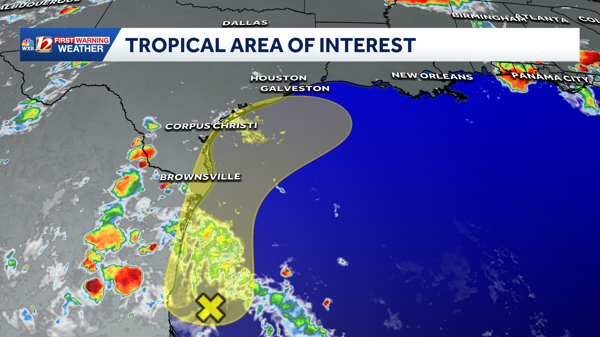
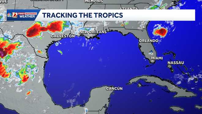
There is currently a slight chance of tropical development in the Gulf from a broad area of low pressure that formed the second week of June off of Mexico’s northeastern coastline. While the low pressure is currently a disorganized area of disturbed weather, rain and thunderstorms may begin impacting parts of Texas from Brownsville to Corpus Christi within the next few days. And while the area of disturbed weather may briefly move inland over northern Mexico, tropical forecast models show a reemergence of the system over the Gulf on Tuesday or Wednesday.
Right now, there is a low chance of development within the next seven days. It is an area to monitor, as conditions may change once a front becomes stationary over the Deep South later this week.
Gulf: Latest tropical development potential
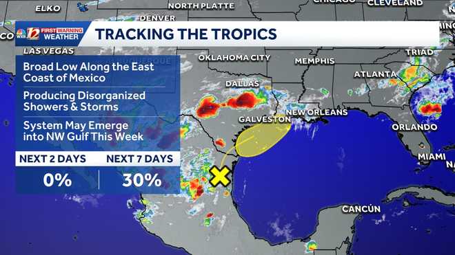
Gulf: Low pressure may bring rain to Texas coast
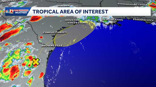
You can find more information on the tropical weather outlook from the National Hurricane Center here in English or here in Spanish.
Gulf: Infrared satellite imagery
This year, the climate pattern known as El Niño is expected to suppress tropical systems in the Atlantic Ocean Basin. Although a slightly less active season is possible, there is no guarantee a direct North Carolina impact won’t happen. Residents know to be prepared for any coastal storm, whether it becomes tropical or whether it originates on another coast. Inland flooding and coastal storm surge are still possible even when a non-tropical system approaches North Carolina. Find out more in the story below.
1 of 6
Tracking the Tropics: Potential areas of tropical development within the next seven days.
2 of 6
Current area of interest for potential tropical development.
3 of 6
Gulf: Infrared Satellite Imagery
4 of 6
This image shows estimated wave heights and current ocean buoy data.
5 of 6
2026 Atlantic Storm Names
This chart shows the 2026 Atlantic storm names.
6 of 6
Tropical Systems Based on Wind Categories (MPH)
This chart shows the level of wind speeds in miles per hour that are needed to be categorized as a tropical system.
More weather coverage: Weather Alerts | Latest weather forecast | Post pictures to the uLocal North Carolina Facebook Group | Traffic information | Report closings and delays | SkyCams | Download the WXII12 News mobile app