
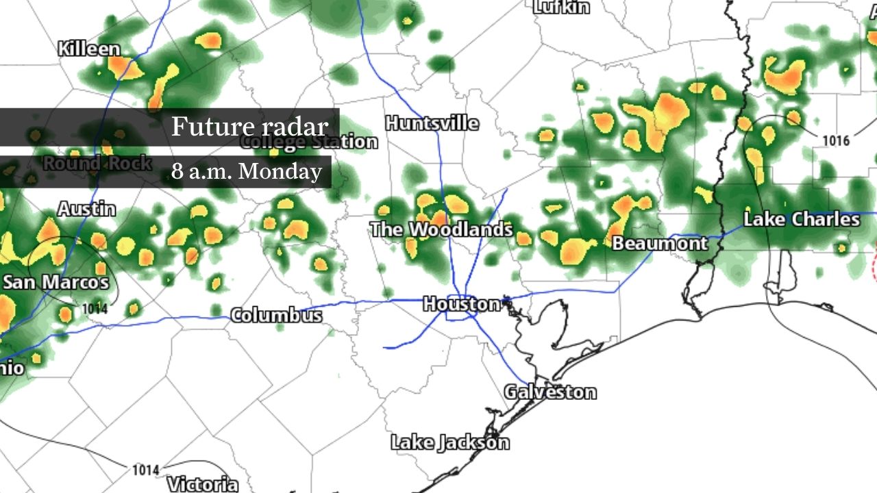
For visitors to Houston who may be unfamiliar with the city’s flood-prone streets, the key message is simple: Heavy downpours can overwhelm drainage systems quickly. A flood watch remains in effect through Wednesday morning as multiple rounds of rain and thunderstorms move across Southeast Texas.
Morning: Most morning commutes should remain rain-free as temperatures climb through the 70s and into the 80s under partly cloudy skies. A few downpours are possible, but widespread rain is not expected during the first half of the day.
Early afternoon: Temperatures reaching the mid- and upper 80s will help fuel scattered showers and thunderstorms. The first storms are expected to develop inland and generally parallel to the coast before spreading toward the Houston metro area.
Late afternoon and evening: Storms should expand toward the Interstate 10 corridor and become more widespread across the Houston area. Periods of heavy rain could create ponding on roads and slow the evening commute in some locations.
Overnight: Storm coverage may briefly decrease before another round of showers and thunderstorms develops overnight into Tuesday as conditions become increasingly favorable for flooding rainfall.
Not everyone will see rain Monday, but many communities are expected to receive at least some. Areas that remain mostly dry could still see heat index values climb into the low 100s, while locations that receive rain should experience temporary relief from the heat.
Rain chances will remain elevated through much of the workweek as a weak area of low pressure moves north along the Texas coast.
The National Hurricane Center is also monitoring a disturbance near northeastern Mexico that could emerge over the western Gulf later this week, though development chances remain low. Regardless of tropical development, the system is expected to help maintain a wet pattern across Texas.
Along the coast, rip currents will remain a concern for the next several days. Above-normal tides could also lead to isolated minor coastal flooding around times of high tide.
Most of the Houston area is expected to receive 2 to 4 inches of rain, though isolated locations could see 6 to 8 inches where thunderstorms repeatedly track over the same neighborhoods.
Houston is especially vulnerable to this type of rainfall because much of the region is flat and heavily paved. When rain falls faster than drainage systems can move water away, streets can flood quickly, particularly in low-lying areas and underpasses. In many parts of the city, roads are intentionally designed to temporarily hold water during intense downpours, meaning street flooding can develop well before homes or businesses are threatened.
Drivers should never attempt to cross flooded roadways, and visitors attending World Cup events should allow extra travel time, as even localized flooding can create significant traffic delays across the area.