
Houston is facing a growing risk of heavy rain and flash flooding this week as World Cup matches bring increased travel across southeast Texas, while forecasters monitor a disturbance over northern Mexico that could move into the Texas coastal waters.
The National Weather Service in Houston/Galveston said a broad area of low pressure over eastern Mexico may re-emerge over the northwestern Gulf of America late Tuesday, June 16, or Wednesday, June 17, where environmental conditions could allow for some development.
Regardless of whether the system organizes, forecasters warn it will bring a prolonged period of heavy rainfall and the potential for dangerous flash flooding across southeast Texas through midweek.
“We are closely monitoring a disturbance over northern Mexico and south Texas,” forecasters noted, adding that the system could strengthen as it moves across the Texas coastal waters late Tuesday and Wednesday.
More: Austin flash flood warning as tropical moisture fuels rain
Flash flooding concerns increase in Houston
The Weather Prediction Center has placed portions of southeast Texas, especially near the coast, under a moderate risk for excessive rainfall through Wednesday.
Rainfall rates could reach 2 to 4 inches per hour, with isolated pockets possibly seeing up to 5 inches per hour in the heaviest storms, according to the National Weather Service in Houston-Galveston. Total rainfall of 2 to 7 inches is forecast, though forecasters warn some areas could see higher localized amounts in a short period.
Isolated areas can expect more than 10 inches, according to the National Weather Service.
“This is a moisture-rich and highly efficient rainfall environment,” the NWS Houston discussion stated, noting that atmospheric conditions are already above the 90th percentile for late June moisture levels.
Forecasters say flash flooding is possible, especially in urban and low-lying areas with poor drainage. Prolonged rainfall could also lead to rises in creek, river, and stream levels as soils become increasingly saturated.
Lightning, tornadoes and wild storms: Incredible weather photos
1 of 55
A haboob comes into Chandler, Ariz. on Aug. 25, 2025.
(Patrick Breen/The Republic)Flash flood watch in effect until early Wednesday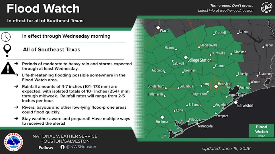
Flash flood warning in effect until early Wednesday morning, June 17, 2026.
Tropical moisture from Mexico fueling storms
The broader setup is tied to tropical moisture associated with a disturbance over Mexico, which is feeding high humidity northward into Texas.
The National Hurricane Center noted a trough of low pressure over northeastern Mexico extending into South Texas, with the potential for additional low-pressure development later this week over the northwestern Gulf.
While the system is not currently a named tropical cyclone, forecasters are monitoring it for possible development as it interacts with a persistent ridge over the Gulf and Atlantic, according to the National Hurricane Center.
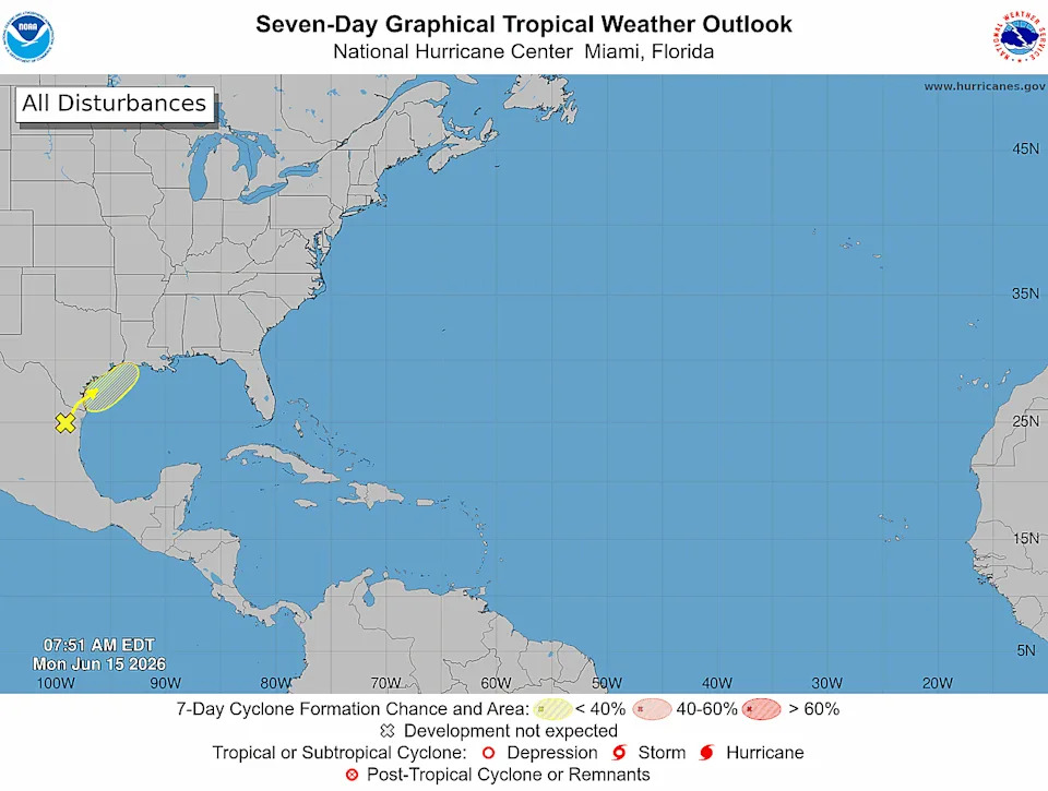
A system in the Gulf could bring heavy rain to portions of Texas and Louisiana this week, according to the National Hurricane Center.
World Cup matches in Houston
Houston is scheduled to host several World Cup matches across the group stage and knockout rounds this summer.
June 14, 2026: Germany vs. Curaçao
June 17, 2026: Portugal vs. DR Congo
June 20, 2026: Netherlands vs. Sweden
June 23, 2026: Portugal vs. Uzbekistan
June 26, 2026: Cape Verde vs. Saudi Arabia
June 29, 2026: Round of 32 (1C vs. 2F)
July 4, 2026: Round of 16 (W73 vs. W75)

HOUSTON, TEXAS – JUNE 14: Manuel Neuer #1 of Germany celebrates the team’s first goal by Felix Nmecha #23 during the FIFA World Cup 2026 Group E match between Germany and Curacao at Houston Stadium on June 14, 2026 in Houston, Texas.
Coastal impacts, wind and surf hazards on Texas coast
In addition to flooding rainfall, the system may bring strong coastal winds and rough marine conditions, according to the National Weather Service.
Winds of 20 to 30 knots are possible over coastal waters, with gusts potentially reaching gale force depending on how the system evolves. Seas could build to 7 to 10 feet, with isolated higher waves up to 14 feet possible.
Along the coast, elevated tides may also lead to minor coastal flooding, particularly Wednesday and Thursday. A moderate to high risk of rip currents is expected each day this week.
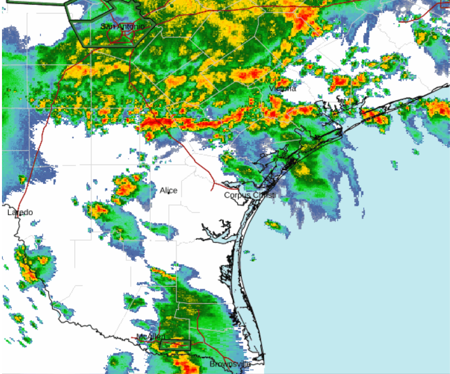
Weather radar shows training storms over Texas coast
Radar trends already show a moisture-rich pattern setting up across the region, with repeated rounds of showers and thunderstorms expected as a stalled boundary interacts with deep Gulf moisture.
Forecasters warn rainfall rates could reach 2 to 4 inches per hour, with isolated bursts up to 5 inches possible in stronger cells.
Atlantic hurricane season 2026: Early Gulf disturbance monitored
While the system is not yet classified as a tropical cyclone, forecasters are closely watching its evolution as it tracks toward the Texas coast.
A broad low-pressure area currently over eastern Mexico could re-emerge over Gulf waters late Tuesday or Wednesday, where conditions may support gradual organization. Even without development, hazards are expected with flooding rainfall, gusty winds and dangerous marine conditions.
The National Hurricane Center is tracking the disturbance with a 30% chance of formation over the next seven days.
Is Houston getting a hurricane? Flood threat outweighs wind risk
At this time, forecasters are not signaling an imminent hurricane threat to the Texas coast. The disturbance currently has a 30% chance of formation over the next week.
Houston weather radarTexas weather watches and warningsStay informed. Get weather alerts via text
Brandi D. Addison covers weather across the United States as the Weather Connect Reporter for the USA TODAY Network. She can be reached at baddison@gannett.com. Follow her on Facebook here.
This article originally appeared on USA TODAY: Houston flood watch as tropical rains threaten World Cup this week