
More rounds of heavy rainfall are expected to return to the Houston metro area Tuesday, prompting the National Weather Service to extend a flood watch for the area until Thursday morning.
Pivotal Weather
Monday’s heavy rain was only the beginning of a potentially dangerous stretch of weather for the Houston metro area.
The concern is not whether it will rain, but how much. Another 4 to 6 inches of rain could fall across parts of Southeast Texas through Thursday as a slow-moving area of low pressure develops near the Texas coast, increasing the risk of flash flooding and flooded roads. The National Hurricane Center is also monitoring the system for possible tropical development, though the flooding threat exists whether it becomes a tropical cyclone or not.
Monday offered an early glimpse of what this week’s weather pattern could do. Most of Harris County received an inch to 3 inches of rain, while parts of central Houston picked up 3 to 5 inches. Those amounts are expected to be only a fraction of what some locations could receive by the end of the week.
Article continues below this ad
Here’s what to watch for:
Flood threat peaks Tuesday night into Wednesday.
Another 4 to 6 inches of rain is possible through Thursday.
Tropical development is possible, but flooding is the main concern.
When will Tuesday’s heaviest rainfall arrive?
Rain chances will remain elevated throughout Tuesday, but the flood threat is expected to increase Tuesday afternoon and evening as a developing area of low pressure moves toward the upper Texas coast.
CLIMATE CONNECTION: El Niño has officially arrived. Here’s what it means for Texas and hurricane season.
Article continues below this ad
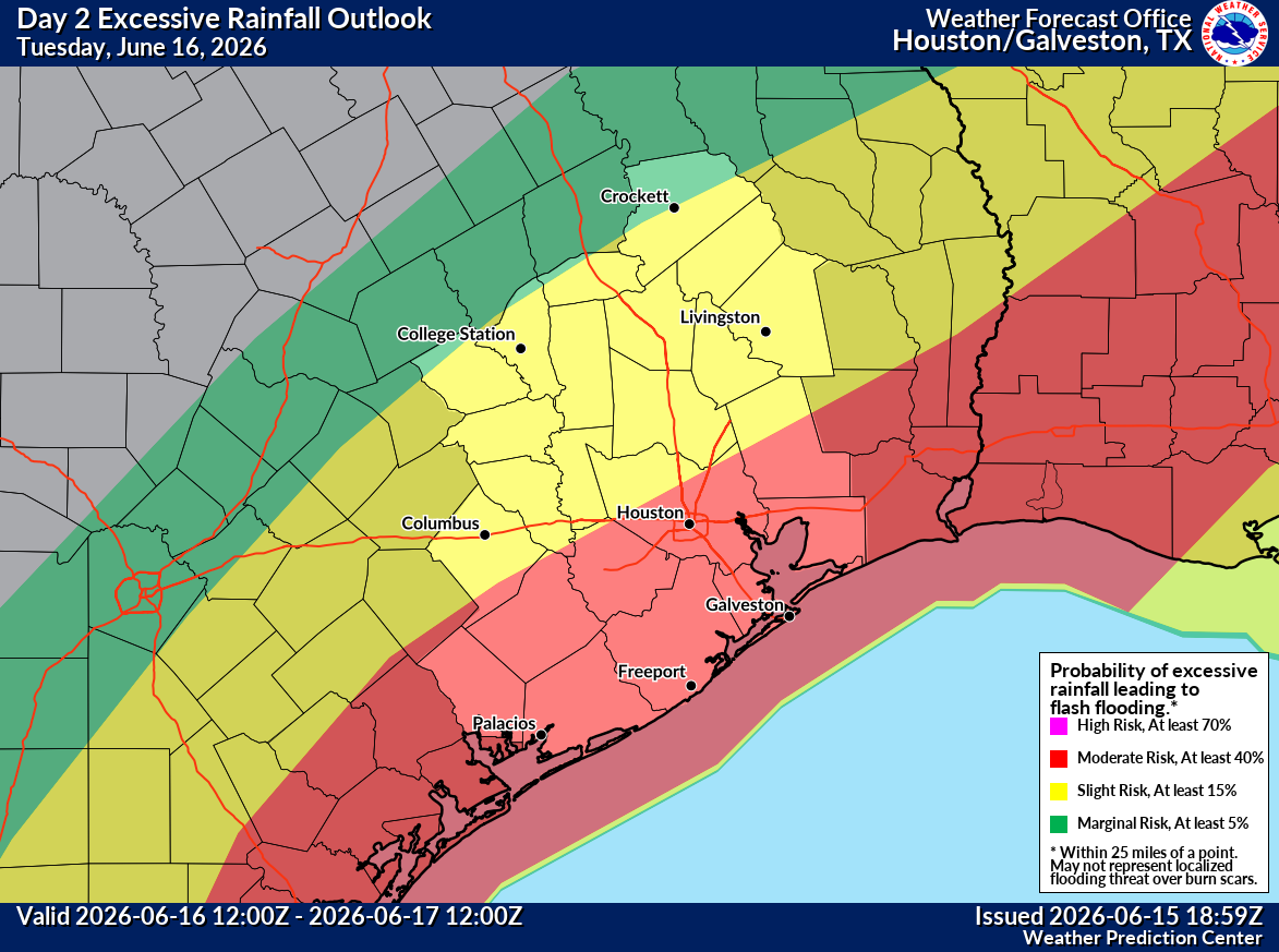
The atmosphere will remain loaded with tropical moisture, allowing storms to produce intense rainfall rates and increasing the risk of repeated downpours over the same places. Rainfall is expected to become more widespread Tuesday night into Wednesday, when the threat for flash flooding will be highest.
Houston’s flood risk peaks Tuesday as deep tropical moisture arrives to the region. The red shading represents a level 3 of 4 risk, or at least a 40% chance, of flooding rainfall, according to NOAA’s Weather Prediction Center.
NOAA’s Weather Prediction Center
The flood risk across Southeast Texas begins to gradually wane by Wednesday, though it does remain elevated near and east of Houston.
NOAA’s Weather Prediction Center
Storm chances diminish Thursday in Southeast Texas, resulting in a slightly lower flood risk compared to areas near and east of Beaumont.
NOAA’s Weather Prediction Center
An area of tropical low pressure should move away from Southeast Texas by Friday, but new downpours, driven primarily by afternoon heat, could renew the threat of localized flooding after a soggy week.
NOAA’s Weather Prediction Center
Some spots could pick up more than half a foot of more rainfall through Thursday, especially where thunderstorms repeatedly track over the same areas. Confidence is growing that parts of Southeast Texas will receive significant rainfall, according to forecast models, but uncertainty remains over exactly where the highest totals will occur.
The heaviest rainfall could develop on the eastern side of the low pressure system, meaning even small shifts in its eventual track could dramatically change which communities see the greatest flooding threat.
For now, confidence is higher in the likelihood of heavy rainfall somewhere in the region than in identifying exactly where the worst flooding will occur.
Article continues below this ad
What about the rest of the week and the tropics?
The low pressure system could briefly organize after emerging over the Gulf of Mexico on Tuesday or Wednesday, and a tropical storm cannot be ruled out if it spends enough time over water.
HOUSTON WEATHER [SIMPLIFIED]: Sign up for texts to get forecasts and extreme weather alerts on your phone.
The National Hurricane Center continues to monitor the disturbance for possible tropical development, but whether it becomes a named storm is less important than its potential hazards. Heavy rainfall, flooding, gusty winds and minor coastal flooding remain the primary concerns through midweek. Tropical storm watches or warnings could be issued for portions of the upper Texas coast as early as Tuesday if the system becomes better organized.
Article continues below this ad
The greatest threat remains flooding. The National Hurricane Center warns that repeated rounds of heavy rainfall could lead to widespread flash, urban and river flooding across parts of Southeast Texas during the next several days.
Conditions should begin improving by Friday as the system moves northeast of Texas. A return to hotter and more typical June weather is expected over the weekend, with heat index values climbing back into the triple digits across parts of the region.