
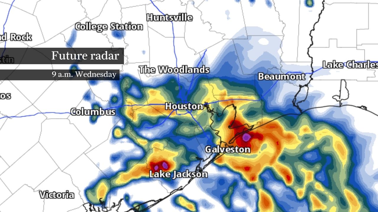
Heavy rainfall and the potential for flash flooding are most likely through Wednesday morning. Rainfall rates of 2 to 4 inches per hour are possible, especially south of Houston.
Pivotal Weather
A tropical disturbance expected to become Tropical Storm Arthur later Wednesday will keep flooding concerns elevated across Southeast Texas through the afternoon, with more rounds of heavy rainfall expected near and along the coast.
The greatest threat for flash flooding will continue through the morning and early afternoon. The weather will gradually improve from west to east later Wednesday as the system lifts toward the Texas-Louisiana border.
A flood watch remains in effect through Wednesday evening for much of Southeast Texas, including Harris, Fort Bend, Montgomery, Galveston, Brazoria, Chambers, Liberty, Wharton and Matagorda counties. Excessive rainfall could trigger flooding of streets, creeks, rivers and other low-lying areas.
Article continues below this ad
A tropical storm watch is also in effect for Galveston Bay, Galveston Island, the Bolivar Peninsula, Chambers County and coastal portions of Brazoria and Galveston counties, where brief tropical storm-force winds of at least 39 mph remain possible through Wednesday.
Flash flood warnings expand across Southeast Texas
A flash flood warning remains in effect through midmorning for portions of Harris, Chambers and Liberty counties, where radar indicated 2 to 3 inches of rain had already fallen by Wednesday morning.
Rainfall rates of 2 to 4 inches per hour could trigger rapid flooding in areas including Pasadena, Baytown, La Porte, Deer Park, Channelview, Crosby, Kingwood, Liberty and Dayton. Forecasters warned that streets, underpasses, creeks and other low-lying areas could quickly flood as more storms move through the region.
Article continues below this ad
STORM TRACKER: See where storms are hitting with the Houston Chronicle’s Live Texas Weather Radar and Storm Map.
Farther south, flash flooding is also ongoing across southeastern Brazoria County, where 5 to nearly 8 inches of rain have fallen since midnight, prompting a separate flash flood warning.
Another 1 to 2 inches of rain could fall in the warned area through the morning, where life-threatening flooding is ongoing. The warning includes Freeport, Clute, Surfside Beach, eastern Angleton, Danbury and nearby communities.
This image shows estimated rainfall totals since midnight in portions of southern Brazoria County. Life-threatening flash flooding was ongoing early Wednesday morning, according to the regional National Weather Service office for Houston and Galveston.
RadarScope
Heavy rainfall remains the primary threat across Southeast Texas through Wednesday afternoon. Coastal communities face the greatest flood risk, where rainfall rates could exceed 4 inches per hour in the strongest storms.
Article continues below this ad
HOUSTON WEATHER [SIMPLIFIED]: Sign up for texts to get forecasts and extreme weather alerts on your phone.
Another 2 to 4 inches of rain are possible across much of the region, with isolated higher amounts, especially along the coast. Saturated soils from recent rainfall could allow water to run off more quickly, increasing the flood threat in areas that have already received several inches of rain over the past few days.
Coastal flooding, gusty winds and isolated tornadoes?
Beyond the flash flood threat, storm surge flooding will remain possible along the coast through Wednesday as persistent onshore winds push water inland.
A coastal flood warning remains in effect for Bolivar Peninsula, while coastal flood advisories cover Galveston Island and portions of the Brazoria and Matagorda coast. Storm surge of 1 to 3 feet above ground level is possible along portions of the upper Texas coast, with the highest water levels expected around high tide through Wednesday afternoon.
Article continues below this ad
6/17 4am CDT Key Messages for Potential Tropical Cyclone #One. The main hazard will be the potential for life-threatening flash flooding from heavy rainfall for portions of the southern and southeastern U.S. Visit https://t.co/tW4KeGdBFb for the latest updates. pic.twitter.com/8Ahd93dpmd
— National Hurricane Center (@NHC_Atlantic) June 17, 2026
A tropical storm warning remains in effect for portions of the offshore waters, where sustained winds could approach 40 mph with higher gusts. Brief tropical storm-force wind gusts also remain possible along parts of the upper Texas coast through Wednesday.
Tropical systems can produce quick spin-up tornadoes, leaving the immediate coast under a low-end tornado risk through Wednesday.
The weather should begin improving Wednesday evening as rain shifts east with the departing system, bringing a gradual end to flooding and storm threats across Southeast Texas overnight.
Article continues below this ad