
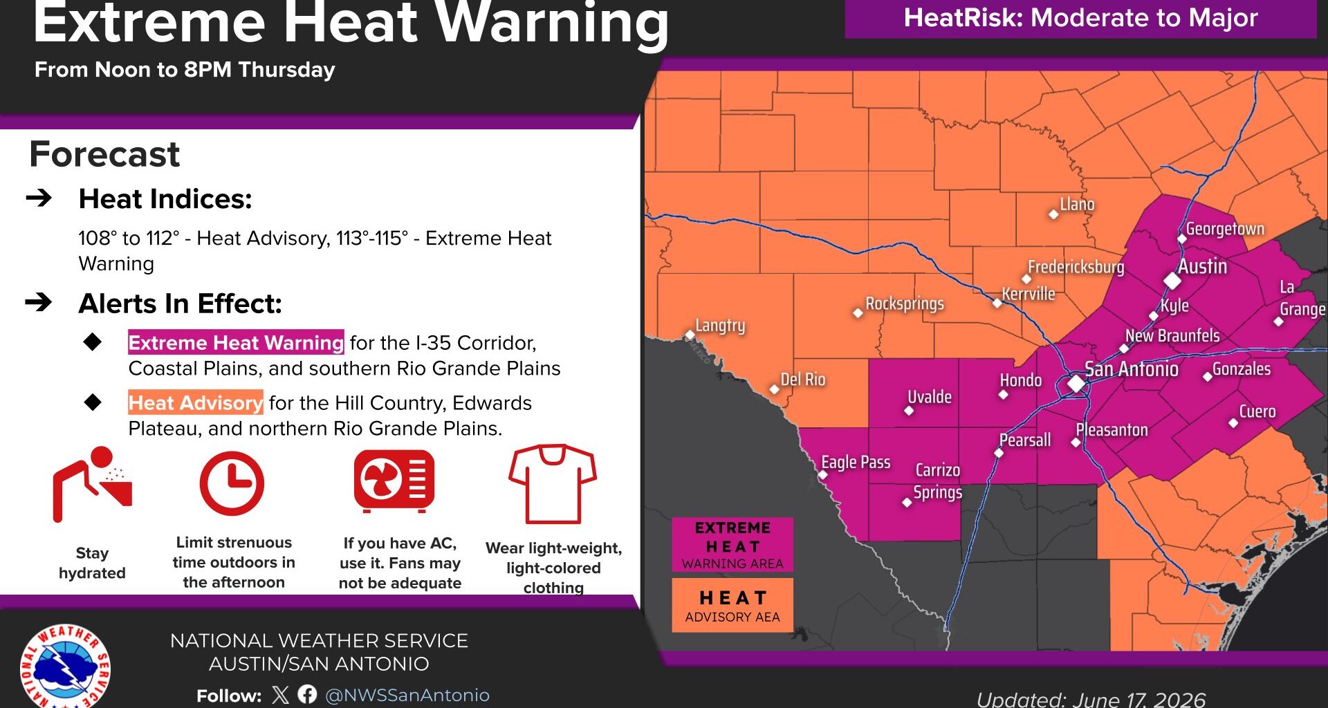
With the heat building on Thursday, residents in South and Central Texas need to take precautions and practice heat safety. An excessive heat warning and a heat advisory is in effect until Thursday evening, according to the National Weather Service.
National Weather Service
An extreme heat warning and heat advisory are in effect from noon to 8 p.m. Thursday across all Central Texas, with afternoon highs climbing into the mid to upper 90s and heat index values soaring between 108 and 115 degrees.

The National Weather Service issued its extreme heat warning for the Austin metro area and Texas counties along the Interstate 35 corridor because it expects heat index values, or the humidity-driven “feels like” temperatures, to reach above 113 degrees.
Article continues below this ad
The heat advisory was in place for the Texas Hill Country because heat index readings were likely to stay between 108 to 112 degrees, according to the weather service.
Although the typical extreme heat of Texas summer has taken its time to arrive in Central Texas this June — with plenty of clouds, rain and relatively mild temperatures — all that changes Thursday and into the weekend as a surge of heat and humidity settles in.
Thursday forecast
The morning will start out warm, cloudy and muggy, with temperatures dropping only into the upper 70s to near 80 degrees amid light southerly winds.
Article continues below this ad
By midday, skies will begin to clear, and winds will increase with gusts of up to 20 mph. Temperatures will quickly hit the lower 90s and, with high humidity in place, heat index values will reach 102 to 106 degrees.
Temperatures will soar into the upper 90s with humidity-driven heat index readings, or “feels like” temperatures, climbing into the 100- to 115-degree range.
Pivotal
By late afternoon, Austin will face continued gusty winds and peak daytime temperatures between 94 and 98 degrees — potentially the city’s hottest air temperatures so far this year. When factoring in the humidity, heat index values will climb into higher, more dangerous levels, between 110 and 115 degrees.
Article continues below this ad
On hot days, we rely on the evaporation of sweat from our skin to cool down. But high humidity makes that process less efficient because the air is already filled with water vapor. The heat index takes this into account to more accurately describe the heat the body experiences, at least better than what actual air temperatures would suggest.
Because your body’s ability to cool down is compromised, humidity-boosted heat can become dangerous for those performing activities outside. You risk heat exhaustion or heatstroke if you don’t take adequate precautions for the heat.
Friday forecast
Friday will be like Thursday but with winds shifting a little more easterly. Air temperatures and dew point temperatures (indicating water vapor saturation in the air) might be a little lower, which means the heat index readings will drop by a few degrees. But the mugginess will still be extremely uncomfortable.
Article continues below this ad
Morning lows will dip to 80 degrees under a mostly cloudy sky, then warm into the mid-90s with a mix of sun and clouds in the afternoon. Winds will be light out of the south between 5 and 10 miles per hour. Heat indices will range from 105 to 110 degrees, so a Heat Advisory may be needed for the Interstate-35 corridor and the coastal plains, but the Hill Country should be below criteria.
Why is it so hot and humid?
You might think the heat and humidity arrived out of nowhere, but the simple meteorological explanation involves recent heavy rainfall and a tropical storm system along the Texas coast.
Article continues below this ad
Moist ground from earlier rainfall is adding extra moisture to the air through evapotranspiration — a process that includes evaporation from the soil and transpiration from plants as they release water by essentially “sweating” through their leaves. Both processes contribute to higher humidity levels.
At the same time, Central Texas is sitting several miles west of Tropical Storm Arthur along the Gulf Coast. The system’s counterclockwise wind flow draws in cooler, drier air into the upper atmosphere. As the air sinks toward the surface, the air compresses and warms, further enhancing the heat.
The combination of these factors is producing an unusually hot and humid stretch of weather for this time of year.
Heat will be the main weather story across Central Texas over the next few days, but don’t put away the rain gear just yet. Rain chances are expected to return this weekend, with additional opportunities for showers and storms lingering into next week. #txwx pic.twitter.com/9wp6gLz9I8
— Mary Wasson (@Mary_Wasson) June 17, 2026
Weekend forecast
The heat and humidity will stick around through the weekend, but a weak front is set to move into Central Texas by Friday night, bringing a good chance for scattered showers and thunderstorms into Saturday.
Article continues below this ad
A brief ridge of high atmospheric pressure will then build in on Sunday and Monday, leading to a short-lived return to warmer and drier weather. However, rain chances are expected to return by the middle of next week.