
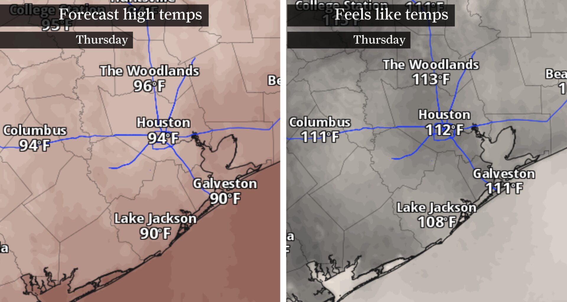
A heat advisory goes into effect for Southeast Texas Thursday, as peak heat index values could reach 110 degrees or higher during the afternoon.
Pivotal Weather
After days of flooding rain and the emergence of Tropical Storm Arthur, Houston’s weather is about to make a familiar June shift. The rain chances will gradually fade. The clouds will break apart — and temperatures will start climbing back into the 90s.
The National Weather Service has already issued a heat advisory for much of Southeast Texas from Thursday morning through Friday evening, warning that heat index values, or humidity-driven “feels like” temperatures, could reach 107 to 114 degrees.
SHIFTING OUTLOOK: A quieter hurricane season is taking shape for Texas. Don’t let that fool you.
Article continues below this ad
Wait, aren’t tropical storms supposed to cool things down?
In the short term, yes. Arthur’s clouds and rain have helped keep temperatures in check across Southeast Texas this week. But once the storm moves away, it can leave behind the ingredients for some of the stickiest weather of the summer.
Arthur left Houston with plenty of moisture
The first reason is easy to spot: rainfall.
Tropical systems dump enormous amounts of moisture across the landscape. Lawns, fields, forests and even city streets hold onto some of that water after the rain ends.
Article continues below this ad
Then the sun comes back out.
As the ground begins drying out, some of that moisture evaporates back into the atmosphere. The result is air so saturated with water vapor that it can feel even steamier after the storm has moved away.
It’s one reason Houston often feels like a sauna after a tropical system passes through.
Arthur’s departure brings in clear skies
There’s another factor working behind the scenes.
Article continues below this ad
Tropical cyclones are built around rising air. As a storm moves away, areas on its western or backside often experience sinking air instead.
CLIMATE CONNECTION: El Niño has officially arrived. Here’s what it means for Texas and hurricane season.
Meteorologists call this subsidence. Sinking air tends to warm up through compression as it descends, and it also helps suppress cloud development. Fewer clouds mean more sunshine reaching the ground, which helps temperatures rebound quickly.
It’s one of the reasons a rainy stretch can sometimes be followed by a surprisingly hot one.
Houston knows this feeling
Houstonians don’t need a lesson on humidity. Everyone here knows what it feels like to step outside after a summer rain shower and somehow find the air even steamier than before. Your sunglasses fog up. The air feels thicker. The walk from the parking lot suddenly feels longer than it should.
Article continues below this ad
Arthur’s rain might have moved out, but much of the moisture it left behind is now in the air as vapor.
However, because we rely on the evaporation of sweat from our skin to cool down, your body retains more heat when the air is already filled with water vapor. That’s why it can sometimes feel hotter after a tropical system than it did before.
WORLD CUP WEATHER: Houston’s World Cup will arrive during peak heat. Here’s what visitors should know about the weather.
When your body’s ability to cool down is compromised from humidity-boosted heat, that can become dangerous for those working, playing or spending extended periods outside. You risk heat exhaustion or heatstroke if you don’t take adequate precautions for this kind of heat.
Article continues below this ad
In fact, the heat building behind Arthur has already triggered a heat advisory from the National Weather Service for much of the Houston metro area, effective Thursday and into Friday, when heat index values could surpass 108 degrees.
Tropical Storm Warning remains in effect for Brazoria, Galveston, and Chambers counties & coastal waters. Expect wind gusts of 40-60 mph near the coast, diminishing by evening. A Heat Advisory is in effect for SE Texas Thu-Fri, with heat indices of 107-114°F. #txwx #houwx pic.twitter.com/D4uE7Y1BXU
— NWS Houston (@NWSHouston) June 17, 2026
So if Houston suddenly feels steamier later this week, it isn’t your imagination. Arthur may no longer be a tropical storm, but the atmosphere over Southeast Texas is still carrying its fingerprints.