
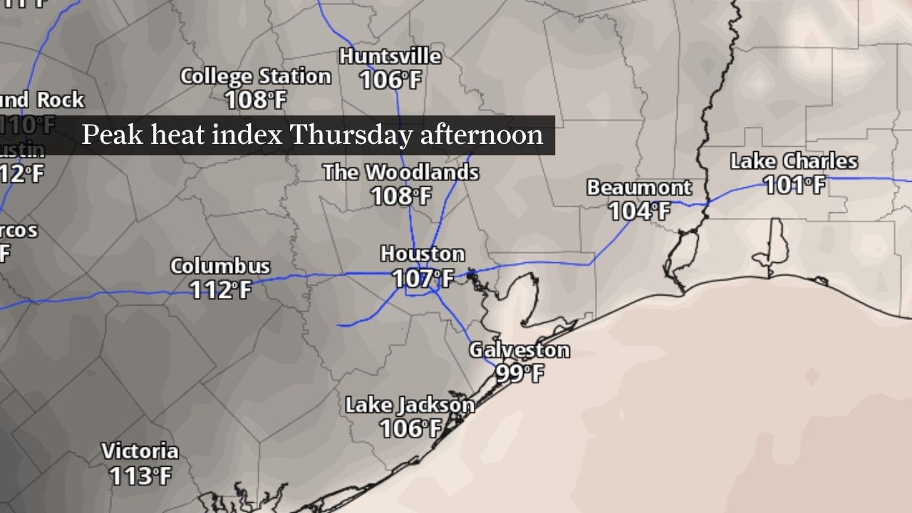
Heat index values are expected to reach between 105 and 110 degrees in most of Southeast Texas on Thursday, prompting the region’s first heat advisory in more than a year.
Pivotal Weather
Arthur’s departure is giving way to a new weather threat: dangerous heat that could send heat index values, or humidity-driven “feels like” temperatures, to as high as 115 degrees this weekend.
The remnants of Tropical Storm Arthur will be well east of Texas by Thursday, but the tropical moisture left behind will linger across the region. Combined with saturated soils, abundant sunshine and strengthening high pressure, that moisture will fuel exceptionally high humidity levels and especially warm nights.
Article continues below this ad
A heat advisory is in effect from 11 a.m. Thursday through 10 p.m. Friday for Houston and much of Southeast Texas, with dangerous heat expected to persist through the weekend and into next week.
The regional National Weather Service office for Houston and Galveston typically issues a heat advisory when the heat index surpasses 108 degrees. That’s a level of humidity-boosted heat that can pose a danger to older adults, younger children and others whose bodies have less efficient circulation systems to help them cool down.
Dangerous heat expected Thursday and Friday
High temperatures will climb into the lower 90s Thursday and Friday, but humidity will make conditions feel substantially hotter. Heat index values are expected to range from 107 to 114 degrees during the afternoon and early evening hours. That’s what prompted the weather service to issue a heat advisory for Houston and much of Southeast Texas.
HOW HOT IS IT? : As temperatures spike this week, see how far from normal highs will be where you live or work.
Article continues below this ad
The advisory covers areas from College Station and Huntsville south to Houston, Galveston and the coastal counties.
Dew point temperatures, which is how cool the air has to be for dew to form, can be a good indicator of how saturated the air is with water vapor. Air gets uncomfortably muggy when dew points are above 65 degrees. But in the coming days, they will climb into the upper 70s and lower 80s, creating an atmosphere that will feel unusually sticky and tropical, even by Southeast Texas standards.
Little relief is expected after sunset. Overnight lows will only fall to around 80 degrees through the weekend, limiting the body’s ability to recover from daytime heat.
On hot days, we rely on the evaporation of sweat from our skin to cool down. But high humidity makes that process less efficient because air is already filled with water vapor. The heat index takes this into account to more accurately describe how the heat “feels like” to the body, at least better than what actual air temperatures would suggest.
Article continues below this ad
Because your body’s ability to cool down is compromised, excessive humidity with extreme heat can become life-threatening. Multiple days of dangerous heat, combined with warm nights, can increase the risk of heat-related illnesses, especially for those who work outdoors or spend extended periods outside.
This weekend’s forecast: Hot and mostly dry
The weather pattern changes little heading into the weekend, just as Houston prepares for another round of FIFA World Cup festivities.
Saturday is expected to be one of the hottest days of the stretch, with heat index values potentially climbing into the 110 to 115 degree range (43 to 46 degrees Celsius). Visitors arriving from cooler climates may find the combination of heat and humidity particularly challenging. The dangerous conditions could affect thousands of fans heading to Saturday’s Netherlands-Sweden match, as well as those attending FIFA Fan Festival events in EaDo.
Abundant sunshine will continue pushing afternoon temperatures into the lower 90s, while persistent tropical moisture keeps the weather feeling much hotter. Rain chances remain minimal as high atmospheric pressure suppresses widespread thunderstorm development, leaving most of Southeast Texas dry through the weekend.
Article continues below this ad
Humidity levels may ease slightly by Sunday, providing modest relief from the worst conditions. Even so, triple-digit heat index values are expected to persist through the end of the weekend and into early next week.
HEAT DASHBOARD: Houston launches city data dashboard to track heat-related ER visits, health risks
Anyone planning to attend outdoor World Cup events, work outside or spend extended time in the sun should take frequent breaks, drink water before feeling thirsty and seek air-conditioned spaces whenever possible. Children and pets should never be left unattended in vehicles, where temperatures can become life-threatening within minutes. With little overnight relief expected, residents should prepare for several consecutive days of dangerous heat.
Article continues below this ad