
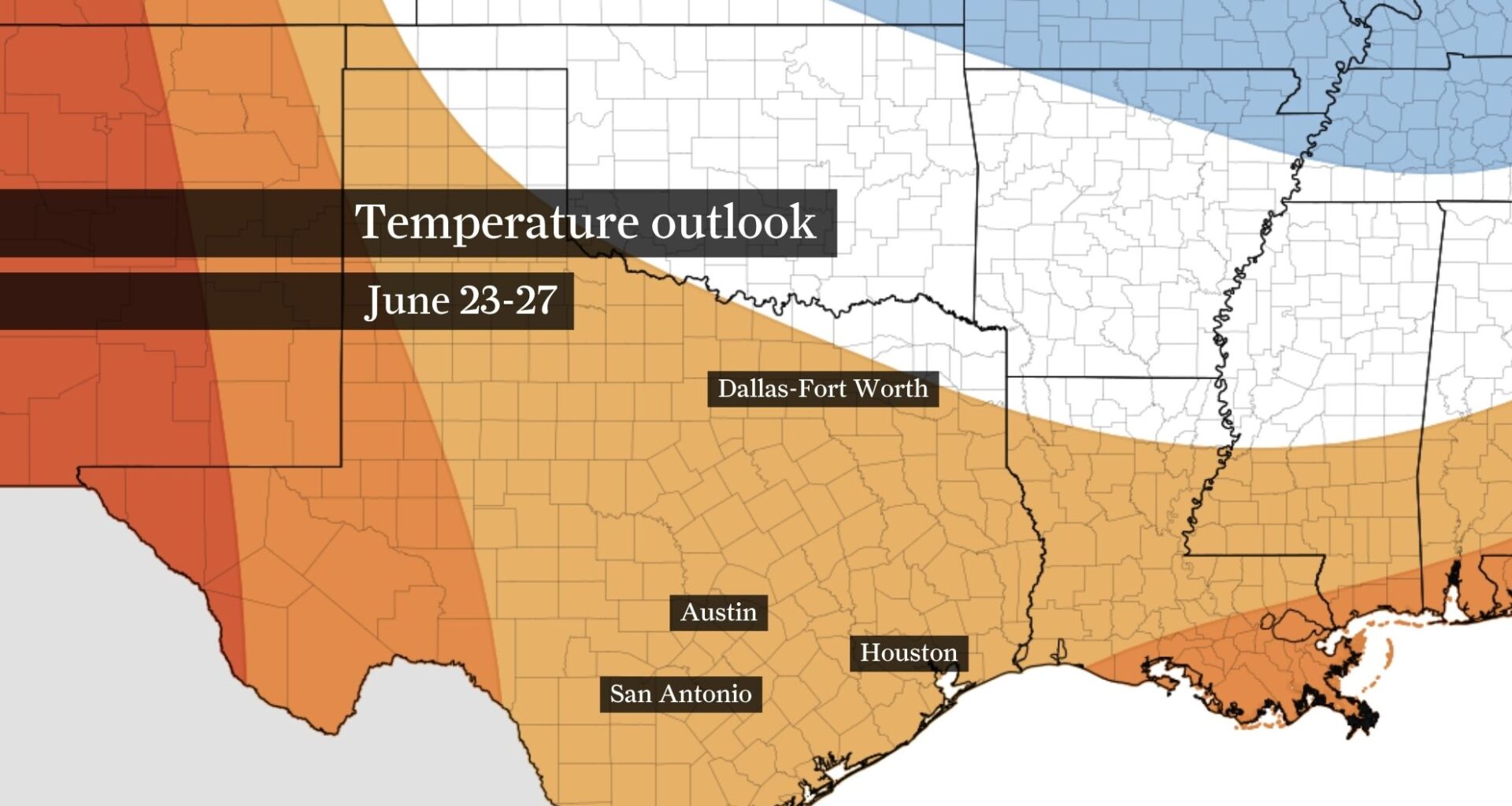
Above-normal temperatures are expected in Texas through much of the second half of June, as shown here by NOAA’s Climate Prediction Center outlook.
NOAA’s Climate Prediction Center / Pivotal Weather
The Houston area may get a break from rainy weather through the second half of June. This outlook shows above-normal rainfall is expected mainly from North Texas to the Panhandle and West Texas.
NOAA’s Climate Prediction Center / Pivotal Weather
Houston’s first prolonged stretch of dangerous summer heat is arriving just as people prepare to gather for Juneteenth celebrations across the region.
Another round of triple-digit heat index values is expected Friday as deep Gulf moisture combines with lingering moisture from this week’s heavy rainfall to make the atmosphere feel more like the swelter of late July than mid-June. A few thunderstorms might provide brief, localized relief by late afternoon or evening, but most of Southeast Texas will spend another day under dangerous heat stress.
DEEP SOUTH FLOOD RISK: Arthur’s remnants unleashed life-threatening flooding across Deep South and Gulf states Thursday.
Article continues below this ad
That’s particularly important for those attending Juneteenth events in Houston and Galveston, many of which include outdoor activities during peak afternoon heat.
Dangerous heat and limited relief from storms
Friday’s forecast calls for temperatures in the mid-90s, but the humidity will make it feel much hotter. Heat index values are expected to climb to between 108 and 112 degrees across much of Southeast Texas, and a heat advisory remains in effect through Friday evening. Overnight temperatures will offer little recovery, only falling into the upper 70s and lower 80s.
Most of Friday should remain rain-free, but a few thunderstorms could develop late in the day and continue into Friday night. A stalled front across North Texas will help spark storms well north of Houston, and some of those storms or their outflow boundaries could drift as far south as the Interstate 10 corridor by late afternoon or evening.
Article continues below this ad
Exactly who gets wet remains uncertain, but scattered storms appear possible, particularly north and west of Houston. A few stronger storms could produce gusty winds and locally heavy rainfall. While widespread flooding is not expected, isolated street flooding is possible as heavier downpours develop, particularly north of Houston, where soils remain saturated from recent rainfall.
Juneteenth celebrations will require extra heat precautions
Anyone attending Juneteenth events — whether touring historic sites, visiting museums, gathering at Emancipation Park, attending performances in Hermann Park or participating in outdoor celebrations in Galveston — should plan for humidity-boosted heat that can become dangerous after just a short time outdoors.
The combination of temperatures in the 90s and humidity driving heat index values to 105 degrees can quickly lead to heat exhaustion, especially for children, older adults and anyone spending extended periods outside. Drink water before feeling thirsty, seek shade or air conditioning whenever possible and watch for signs of heat illness, including dizziness, nausea, headaches and unusual fatigue.
Article continues below this ad
Many Juneteenth celebrations continue into the evening hours, when temperatures will gradually ease, but humidity will remain high. Even after sunset, the weather will stay warm enough to warrant caution.
Houston’s hottest stretch of summer is still ahead
As intense as this week’s heat may seem, Houston’s climatological hottest weather typically arrives later in the summer.
Article continues below this ad
Average high temperatures peak near 95 degrees in July and August, with Houston’s warmest stretch usually occurring from late July into early August. If triple-digit temperatures are the benchmark, Houston historically records most of its 100-degree days between about July 19 and Aug. 17.
In other words, this week’s heat is arriving ahead of Houston’s climatological peak. While a few storms may offer occasional relief in the days ahead, the period that historically produces Houston’s most persistent and intense heat remains several weeks away.