
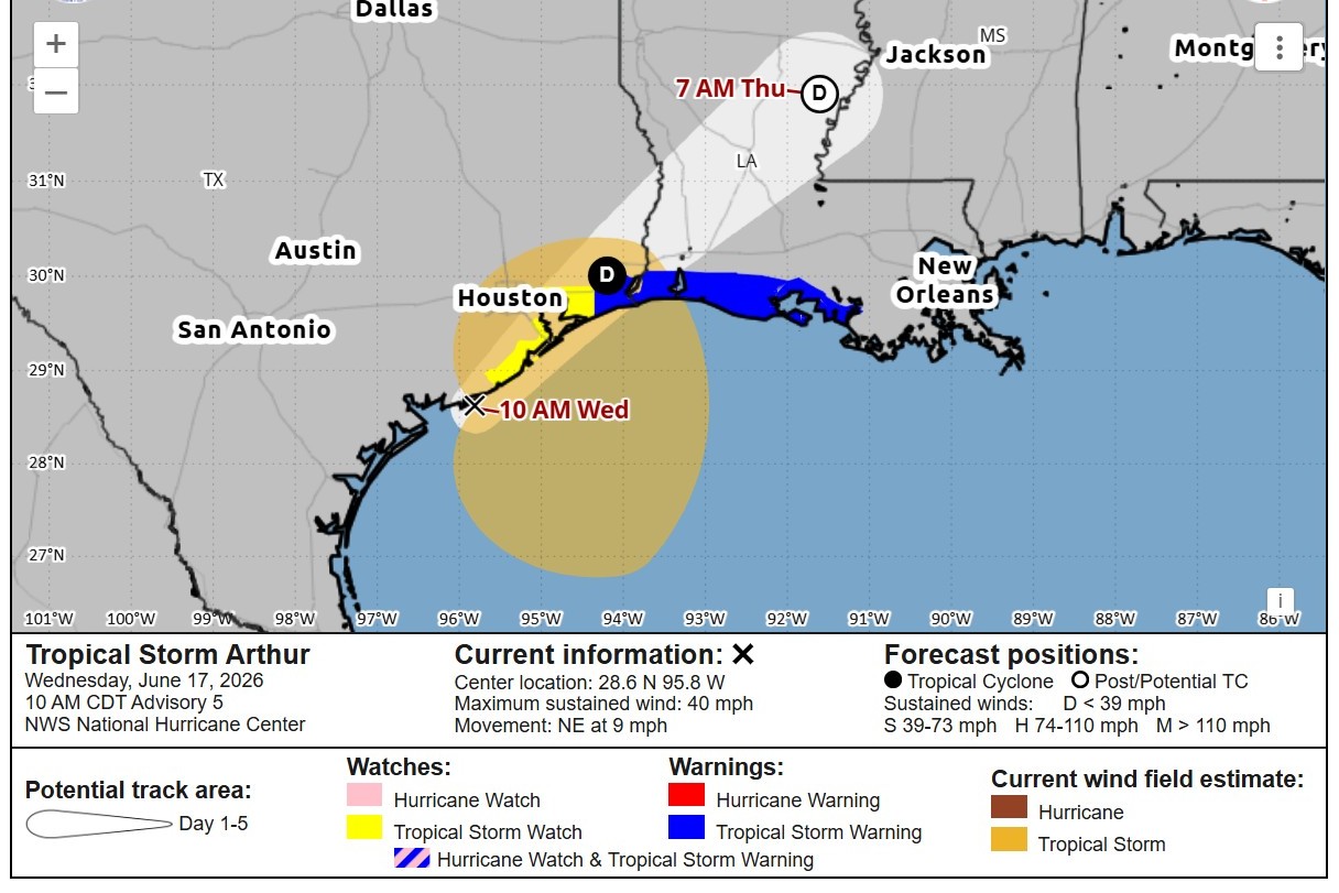
The center of Tropical Storm Arthur is expected to remain near or just offshore of the upper Texas coastline before crossing inland east of the Sabine River.
National Hurricane Center
Tropical Storm Arthur has formed in the western Gulf of Mexico, becoming the Atlantic hurricane season’s first named storm as it tracks northeast along the Texas coast.
As of 10 a.m., the rotating center of Arthur was about 40 miles east-northeast of Port O’Connor, with maximum sustained winds of 40 mph, making it a low-end tropical storm. The storm was moving northeast at 9 mph, according to the National Hurricane Center.
WORLD CUP MATCH: Whitmire says storm threat should not impact Portugal vs. DR Congo match in Houston
Article continues below this ad
A tropical storm warning was in effect for the Gulf Coast from High Island in Southeast Texas to Morgan City on the central Louisiana coast. A tropical storm warning means that tropical storm winds of at least 39 mph are expected within the warning area, in this case within 12 hours, the hurricane center said.
Arthur is expected to remain relatively weak and short-lived, moving near the upper Texas coast Wednesday before making landfall in Louisiana later Wednesday or Wednesday night.
National Hurricane Center
The storm is expected to remain relatively weak and short-lived, moving near the upper Texas coast Wednesday before making landfall in Louisiana later Wednesday or Wednesday night. Arthur should weaken quickly after moving inland and dissipate over central Louisiana by Thursday.
For Houston and Southeast Texas, the storm’s greatest threat remains heavy rainfall and localized flooding through Wednesday.
Article continues below this ad
Where is Tropical Storm Arthur going next?
Arthur is forecast to move northeast along the Texas coast through Wednesday before turning inland across Louisiana.
WORDS TO KNOW: What is a tropical cyclone? Watch vs. warning? Here are key tropical weather terms explained.
The storm’s center is expected to remain near or just offshore of the upper Texas coastline before crossing inland east of the Sabine River. While the storm may strengthen somewhat over the warm waters of the Gulf, significant intensification is not anticipated before landfall.
The storm’s relatively fast forward motion should also limit the amount of time it has to strengthen.
Article continues below this ad
What does Tropical Storm Arthur mean for Houston?
Arthur’s development changes little about the forecast for Houston and Southeast Texas, where flooding remains the primary concern through Wednesday.
Periods of heavy rainfall will continue across the region as tropical moisture spreads inland from the Gulf. Rainfall totals will vary considerably depending on where rain bands develop and stall, with some communities receiving far more rain than others.
Localized flash flooding remains possible, especially in low-lying and flood-prone areas. The flood threat appears greatest closer to the coast and east of Houston, where the deepest tropical moisture is expected to reside.
Minor coastal flooding is also possible along portions of the upper Texas coast as water levels rise ahead of the storm.
Article continues below this ad
Why isn’t Houston expected to see Arthur’s worst impacts?
The storm’s heaviest rainfall is expected to develop east of its center, placing the highest flood risk away from much of Southeast Texas.
STORM TRACKER: This hurricane season, stay informed with the Houston Chronicle’s interactive Texas Hurricane and Tropical Storm Tracker.
That pattern should help limit the most significant impacts in Houston, though periods of heavy rain and localized flooding remain possible across the region. Farther east, the same setup increases the risk of life-threatening flash flooding as Arthur moves inland.
Could Arthur strengthen further?
Some strengthening remains possible while Arthur tracks over the Gulf on Wednesday.
Article continues below this ad
Warm Gulf waters and favorable atmospheric conditions should allow the storm to organize further before landfall. Current projections keep Arthur as a tropical storm before it moves inland and begins weakening.
Regardless of any additional strengthening, rainfall and flooding are expected to remain the storm’s most significant hazards for Southeast Texas.