
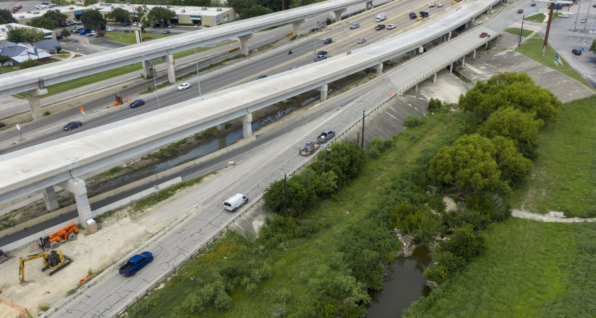
Last June, after Beitel Creek flooded high enough to sweep 15 vehicles off a Loop 410 frontage road, claiming the lives of 11 people, the city of San Antonio hired an engineering firm to investigate what went wrong.

The firm’s report pointed to overgrown vegetation on privately-owned land along the creek as a major cause of the flooding. Dense clusters of trees and shrubs had obstructed the flow, forcing the water higher than computer models predicted, the report said.
The report recommended the city work with property owners to clear that growth.
Article continues below this ad
A year later, the obvious questions are: What has been done about the overgrowth? Has the risk of another deadly flood been reduced?
Those questions are harder to answer than one might expect.
ALSO READ: What caused deadly Beitel Creek flooding? It’s complicated.
Article continues below this ad
The city says it has been working with FSG San Antonio, an electrical construction company based in a warehouse along the creek, to clear vegetation on the property where the warehouse sits, stretching along nearly a half-mile of the creek’s southern bank. “Clean up efforts” were completed in March, and “work continues” to establish a routine maintenance schedule, city spokesperson Brian Chasnoff said.
But the city hasn’t offered specifics about how much vegetation has been cleared — and another property owner along the creek says he hasn’t been able to get city staffers to provide guidance or answer questions.
It’s also unclear how the city is measuring its progress with the vegetation. Neither the consultant’s report nor the city specified how much brush needed to be removed. The city didn’t respond to a question asking whether it has provided guidelines for property owners to follow.
Article continues below this ad
A comparison of satellite images from early 2025 and the current month doesn’t appear to show a significant decrease in the amount of overgrowth. An Express-News reporter visiting the stretch of the creek that flooded, just north of Loop 410, where Beitel veers sharply west through an industrial district, found that the waterway remains hidden behind thick walls of plant life. The creek bed is littered with shopping carts and concrete blocks, as well as wooden boards forming a path to what looks like a homeless encampment.
The city says it has made progress with other recommendations in the engineering report, including working with the Texas Department of Transportation to install warning signs for the access road where the vehicles were swept away. The San Antonio River Authority is developing a sophisticated flood prediction system designed to automatically close roadways via remotely-controlled barriers when they are at risk of flooding.
But taken together, it’s unclear whether Beitel Creek is any less flood-prone today than it was last June. TxDOT is not saying whether it plans to elevate the stretch of the access road that flooded, as the engineering report recommended.
At a vigil last week in remembrance of those who lost their lives in the flood — which struck in the early morning hours of a Thursday, while they were on their way to or from work — some family members of the victims questioned whether enough has been done
Article continues below this ad
“A year later, it’s raining, you still see that creek swell, and it’s scary because it lets me know that everything that could be done, can be done, has not been done,” said Angel Richards, wife of Stevie “Wayne” Richards, who died in the flood. “I just feel like if the creek can rise to that level, no one should have access to that road.”
Angel Richards, wife of flood victim Stevie ‘Wayne’ Richards, holds balloons during a gathering at Beitel Creek on June 13 to honor the people who died in the 2025 flood.
Katina Zentz/San Antonio Express-News
Frustration with city
Chris James is director of operations for Ameripipe Supply, a Dallas-based distributor of fire sprinkler systems that for 20 years had run a local branch from a warehouse about 300 yards upstream of the fatal stretch of the access road. He is also a partner in #40 Real Estate Partnership, the entity that owns the property.
Article continues below this ad
Ameripipe’s warehouse suffered significant damage during the flood. A four-foot wave of water swept through the building, dragging away equipment worth about $500,000, James said. Homeless people later camped on the site, stealing copper wire and air conditioning units, he said.
The damage was so extensive that the company decided to shutter its San Antonio operation, laying off four employees, he said. The plan is to auction off the 6.6 acres of land #40 Real Estate Partnership owns abutting the creek’s northern bank.
No one from the city has contacted Ameripipe about vegetation maintenance, he said. The company cleared some trees after the flood, but only to prevent homeless people from sheltering beneath them, he said.
James said he was unable to reach anyone from the city who could “give us some information about what happened, what their plans are. We didn’t want to spend money building the property back if it was just going to risk being flooded again.”
Article continues below this ad
“I contacted every department I could find,” he said. “Nobody was interested in offering any kind of information or assistance whatsoever. We were interested in fixing the flood problem first, then rehabilitating the property, but we got so frustrated with the city that we just decided we’re going to sell it. We’re going to have to accept money way under market value.”
The company now services its San Antonio customers through its Austin branch, he said.
A year after the flood, the city says it has made progress with other recommendations in the engineering report — drafted by Kleinfelder, a San Diego-based civil engineering firm — according to a document City Manager Erik Walsh sent to Mayor Gina Ortiz Jones and City Council members on May 20, providing a quarterly update.
But much work remains to be done — including following through with the report’s recommendation to clarify who is responsible for keeping the flood zone along Beitel Creek clear of dense vegetation.
Article continues below this ad
Thick brush surrounds Beitel Creek near the Loop 410 access road on June 11. A city-commissioned report said overgrown vegetation was partly to blame for the intensity of the 2025 flooding on the creek.
Andrew J. Whitaker/San Antonio Express-News
Dense vegetation surrounding Beitel Creek on June 11.
Andrew J. Whitaker/San Antonio Express-News
“We have a plan in place. Am I happy with the speed at which things are moving? No, but frankly, I never am,” said District 10 Council Member Marc Whyte, whose district includes much of the stretch of Beitel Creek that flooded. “We have an aging infrastructure in San Antonio, poor streets, water pipes breaking every day, and of course we have these low-crossing areas where we have flooding problems in all four corners of the city.”
Once-in-a-generation flood
Last year’s flood was the deadliest in San Antonio since a 1998 deluge took 11 lives in Bexar County. In the early morning hours of June 12, 2025, record-setting rainfall struck San Antonio. Officials reported more than 7 inches in places.
Article continues below this ad
Beitel Creek surged to more than 20 feet deep and more than 300 yards wide. About 5 a.m., the flow swept up motorists on the Loop 410 access road where it bridges the creek, next to an Academy Sports and Outdoors retail store, just east of Perrin Beitel Road.
A year later, the area around that stretch of Beitel Creek looks much as it did right after the flood, with the exception of barriers put down to block Vicar Road, a low-water crossing over the creek south of Loop 410. That crossing, which was severely damaged in the flood, has been closed permanently, Chasnoff said.
An aerial photo shows construction work on Vicar Drive near Beitel Creek on June 11.
Andrew J. Whitaker/San Antonio Express-News
Construction work along Vicar Drive bridge on June 11, 2026.
Andrew J. Whitaker/San Antonio Express-News
In its fiscal year 2026 budget, the city dedicated $8 million to make repairs to Beitel Creek’s drainage system. In May, the city’s Public Works Department began making temporary repairs to the 0.3-mile concrete channel that carries the creek between Loop 410 and Vicar Road, after the flood tore off parts of the concrete walls, Chasnoff said.
Article continues below this ad
“This work involves sealing damaged or missing concrete wall panels to provide temporary erosion control and prevent further deterioration while permanent, long-term repairs are designed and constructed,” he said.
The city plans to begin long-term repairs in early 2027 and complete them that summer, he said.
Elevate the access road?
The Kleinfelder report set forth other recommendations, including installation of gauges and warning signs on the Loop 410 access road. Another was that the city work with the Texas Department of Transportation to elevate that stretch of the road, referred to as a “sag point,” cutting through the 100-year floodplain for more than 1,000 feet — an area determined by federal officials to have a 1% annual chance of flooding.
Article continues below this ad
Since the flood, TxDOT has added warning signs along the access road, as well as a flood gauge at the low point, agency spokeswoman Jennifer Serold said.
TxDOT has also developed an “emergency road closure and detour procedure” to be activated when heavy rainfall is forecast, so crews can “proactively restrict access and guide traffic to safer routes.”
The agency plans to build a hydraulic barrier along the frontage road to manage water flow as part of its I-35 NEX project, a $3 billion expansion of Interstate 35 on the Northeast Side. The project includes construction of elevated lanes along the stretch of Loop 410 above Beitel Creek; work was underway when the flood struck.
Serold did not say whether TxDOT plans to raise the access road above the floodplain.
Article continues below this ad
Thick brush surrounds Beitel Creek near the Loop 410 access road on June 11. A city-commissioned report said overgrown vegetation was partly to blame for the intensity of the 2025 flooding on the creek.
Andrew J. Whitaker/San Antonio Express-News
The city’s Public Works Department is studying alternatives for the Loop 410 frontage road, according to the quarterly update from the city manager. The study will be shared with TxDOT after its completion this summer.
The quarterly update says the city has updated its emergency management protocols to work with TxDOT to block the frontage road if high-water sensors are activated upstream.
After the Beitel Creek deluge — which was followed by the July 4 Guadalupe River flood that killed 119 in Kerr County — the San Antonio River Authority began developing a comprehensive flood warning system for the region. Dubbed the NextGen Flood Warning System, the project is being funded with $21 million from Bexar County.
Article continues below this ad
The system will collect data from an expanded network of water sensors and feed it into an advanced model to predict when roadways will flood. Automatic barriers will be installed to block roadways when the model indicates a flood risk, said Erin Cavazos, the river authority’s engineering manager.
For example, if a sensor in a creek reports that the water has deepened to five feet, the model might conclude, based on prior analysis, that a road downstream is at risk of flooding, and the automatic gate will come down. Over the next year, the river authority wants to install automatic gates in as many places as possible, Cavazos said.
The authority is compiling a list of roads most at risk, with a view to installing on-site high water detection systems, she said. But it isn’t feasible to install the systems everywhere, as they each cost about $10,000 a year to operate.
“Rather than do that, we’re looking at how we could use these models… to be able to provide actionable information during flood events without having to monitor every road,” she said.
Article continues below this ad
Who’s responsible for the vegetation?
The Kleinfelder report raised an important question: Who is supposed to be controlling the vegetation along the part of Beitel Creek that flooded?
The report said it was not the city’s responsibility. It also noted that drainage easements along the creek — defined areas where the property owners are limited in what they can build because of flood risk — “lack clear ownership and therefore maintenance responsibility which seemingly remains with the landowner.”
The report recommended the city do a legal review to “clarify maintenance responsibilities.”
Article continues below this ad
Records for properties along the creek north of Loop 410 include language making clear that it is the property owner’s responsibility to maintain the drainage easement.
Dense vegetation surrounds Beitel Creek not far from the Loop 410 access road on June 11.
Andrew J. Whitaker/San Antonio Express-News
Thick brush surrounds Beitel Creek near the Loop 410 access road on June 11. A city-commissioned report said overgrown vegetation was partly to blame for the intensity of the 2025 flooding on the creek.
Andrew J. Whitaker/San Antonio Express-News
But the records also say the city and Bexar County have the right to enter the property to remove “impeding obstructions.” The city’s municipal code cites examples when the city might enter an easement to remove blockages with the “potential to significantly affect water flow,” including overgrown vegetation and fallen trees.
Article continues below this ad
The code says property owners must submit a maintenance schedule to the city, to be approved by the director of the city’s Transportation and Capital Improvements Department.
Responding to a question from the Express-News, Chasnoff said no maintenance schedule had been submitted for the property around FSG San Antonio’s warehouse. He said the land was subdivided in 2016, before the city’s development code required such a schedule.
Asked what the city could do to make sure property owners control vegetation, he said, “The property owners have been cooperative.”
Deborah Reid, technical director for the nonprofit Greater Edwards Aquifer Alliance, said owners of private properties often won’t do anything about overgrown vegetation in a flood zone unless a code complaint is filed.
Article continues below this ad
“Is the answer to strip every bit of vegetation out? I don’t think so, personally,” said Reid, who sits on the city’s Storm Water Management Advisory Board and the Texas Water Development Board. “Trees play an important role in the environment and also can be utilized to reduce flooding, if they’re managed.”
She pointed to other factors she considers likely contributors to last year’s flood, including development in Beitel Creek’s watershed and TxDOT’s ongoing I-35 expansion.
“One of the disappointing things is that it wasn’t put out for comment, or even a peer review,” she said of the Kleinfelder report. The Storm Water Management Advisory Board “had to really beg to get a copy of it, because all we had was what was in the newspaper.”
Article continues below this ad
Staff writer Annasofia Scheve contributed to this report.