
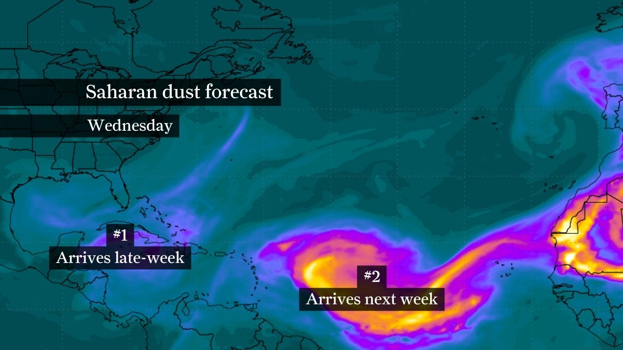
The first Saharan dust plume of the summer is expected to arrive into the Houston area by Friday. That plume, labeled #1 on this image, will be moving across the Caribbean Wednesday.
WeatherBELL
By Friday, Houston’s first Saharan dust plume of the season should be overhead. Concentrations of dust are expected to be light, meaning the health risk to people is relatively low.
WeatherBELL
The second, and likely thicker, plume of Saharan dust — denoted by the #2 on this map — will enter the Gulf of Mexico by Sunday.
WeatherBELL
The thicker Saharan dust plume should move overhead by early next week, likely peaking between Monday and Tuesday. This could pose health risks, especially for those with asthma or other respiratory issues.
WeatherBELLHigh atmospheric pressure will keep Houston hot and mostly dry through the weekend, with afternoons in the lower to mid-90s and mornings in the 70s.A plume of Saharan dust will bring hazier skies and occasional moderate air quality to Southeast Texas later this week, with a larger, denser plume possible by next Tuesday.Isolated afternoon thunderstorms might return to the region next week as humidity increases, but temperatures will stay in the 90s.
Houston faces a one-two punch of hot weather and an increasingly noticeable Saharan dust surge.
Houston will spend the rest of the week under a stubborn dome of high pressure that keeps temperatures in the 90s and rain chances scarce. That same pattern will allow Saharan dust to become a bigger part of the forecast, with a modest plume arriving later this week and a potentially larger plume reaching Texas around Tuesday.
Article continues below this ad
Houston stays hot and dry through this weekend
Houston’s weather pattern won’t change much beginning Wednesday as high pressure remains firmly in control across the Gulf Coast.
RAINY MONTH: Houston started June on a rainy note, but it isn’t lasting forever. Here’s what comes next.
The ridge will suppress cloud development and keep meaningful rain chances out of the forecast through at least the weekend. Expect mostly sunny skies with afternoon highs reaching the lower to middle 90s each day and overnight lows settling into the 70s.
The good news is that humidity levels should remain somewhat manageable compared to a typical late-June pattern. Dew point temperatures, which can indicate moisture saturation levels, are projected to stay a bit lower, helping keep humidity-driven heat index values from triggering a National Weather Service-issued heat advisory, despite the persistent warmth.
Article continues below this ad
Southerly winds will continue off the Gulf of Mexico, but the atmosphere will remain too stable and dry to support widespread thunderstorm development. For now, Houston’s forecast is dominated by sunshine, heat and little chance of rain.
Saharan dust arrives later this week
The first of several likely rounds of Saharan dust will continue spreading across Texas through the end of the week, bringing hazier skies to Southeast Texas.
This initial plume is not expected to be especially dense, but it should be noticeable at times. You may notice sunrises and sunsets looking particularly vibrant as dust particles can enhance reds, oranges and other colors along the horizon.
Article continues below this ad
The Texas Commission on Environmental Quality expects dust concentrations to remain elevated enough that air quality may occasionally slip into the moderate category in the Houston area. Most people won’t notice significant problems beyond the haze, but sensitive groups — like those with asthma or other respiratory conditions — could experience irritation during periods of higher concentrations.
The dust might also help reinforce the dry weather pattern by limiting cloud development and reducing the atmosphere’s ability to generate showers.
Looking ahead to a potentially larger plume of Saharan dust
Attention is already turning to a larger plume of Saharan dust now moving across the eastern Atlantic.
This visible satellite image captured Tuesday afternoon shows Saharan dust moving across the Atlantic toward the Caribbean. By Friday, this plume will reach the Houston area in a lighter concentration.
National Oceanic and Atmospheric Administration
Forecast models continue to depict a larger and denser plume of Saharan dust moving west from Africa, crossing the tropical Atlantic and approaching the Caribbean and Gulf of Mexico early next week. Current projections suggest some of that dust could begin reaching Texas around Tuesday, though the exact timing and concentration remain subject to change.
Article continues below this ad
The latest model guidance shows a broad ribbon of dust extending across much of the Atlantic basin, with some areas of the plume appearing denser than the dust expected to reach Texas later this week. A denser plume could also lead to more noticeable air-quality hazards, particularly for people with asthma, allergies and other respiratory conditions, as particulate levels increase.
SIGN UP TODAY: Get forecasts and extreme weather alerts sent straight to your phone.
If the plume holds together during its 4,000-mile journey across the Atlantic, Houston could experience noticeably hazier skies, reduced visibility at times and another round of vivid sunrises and sunsets by the middle of next week.
By then, the weather pattern may also begin to evolve. As the ridge of high pressure gradually shifts eastward, increased humidity should slowly return to Southeast Texas, allowing isolated afternoon thunderstorms to reenter the forecast next week. Temperatures, however, are expected to remain in the lower to mid-90s.
Article continues below this ad