
Over the past few weeks, San Antonio’s weather pattern has been characterized by high Gulf moisture levels and consistent atmospheric disturbances that brought heavy, tropical downpours. San Antonio has already recorded 6.57 inches of rain so far this month, which is double June’s typical amount, and is responsible for the city’s fifth-rainiest June since 1990.
However, the weather pattern has finally flipped as high atmospheric pressure has developed across South and Central Texas. San Antonio has gone three straight days without rain, and weather models suggest that dry weather might continue through the end of the month. When might rain push back into the forecast? Here’s what we know.
Mild yet comfortable weather is expected Wednesday morning, as San Antonio temperatures will sit in the mid- to upper 70s through 9 a.m. Clouds are expected early on, but skies are expected to become mostly sunny by 10 a.m.
Temperatures will rise steadily throughout the day, likely reaching the mid-80s at 11 a.m. Afternoon highs are expected to top out at 93 degrees, which is near average for late June. Skies will be mostly sunny, and winds will likely move in from the south at 10 to 15 mph.
Afternoon and evening skies might turn slightly hazy, as light concentrations of Saharan dust move into the region. The air quality is likely to become unhealthy for sensitive groups, including infants, the elderly, and those with asthma or other respiratory conditions. Dust may also lead to allergy flare-ups.
Humidity levels will drop as drier air moves into South Texas during the afternoon. This will lead to heat index values topping out only near 97 degrees, a noticeable improvement over the oppressive humidity experienced last week across the region.
The weather over the next several days is expected to stay remarkably consistent. On Thursday, San Antonio will once again see temperatures peak near 93 degrees, rising slightly to around 95 degrees by Friday and the weekend. Skies will stay partly cloudy each morning, becoming mostly sunny by the afternoon.
Humidity levels will also become slightly higher over the weekend, resulting in “feels like” temps rising back over 100 degrees.
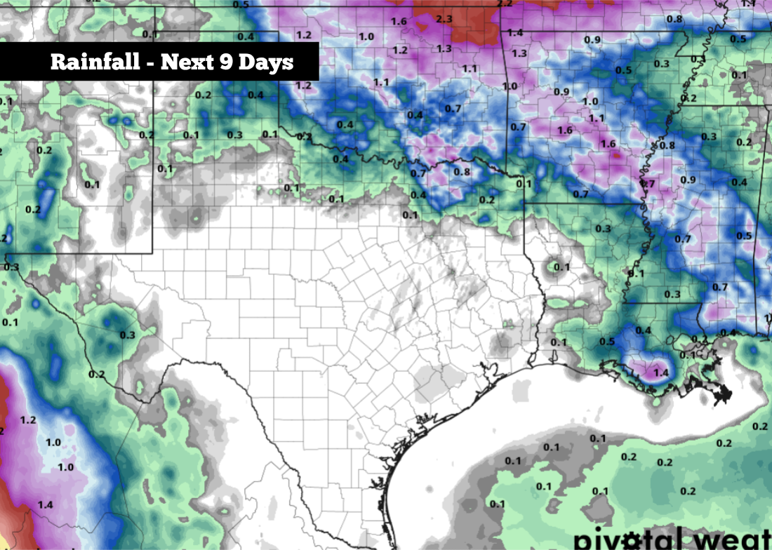
Most of Texas will also stay completely dry through the weekend. The only parts of the state that will see a slight chance of scattered storms include far North Texas, the Panhandle, and the high elevations of West Texas.
Dry weather is also expected to continue into next week as well, as a new system of high atmospheric pressure develops just to the north and east of Texas. According to the National Blend of Models, no rain is expected in the San Antonio metro area over the next nine days. Afternoon high temps will also continue to hover in the mid-90s.
Long-range weather models do show the potential of a few scattered showers and storms by the July 3-5 timeframe. However, rain chances still appear slim during this time, with widespread activity not expected.