
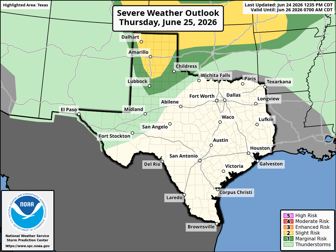
Parts of the Texas Panhandle is under a level 2 of 5 risk of scattered severe thunderstorms on Thursday. Some storms could produce isolated hail and damaging winds.
Storm Prediction Center
High atmospheric pressure has taken control of the weather across South-Central Texas, which has led to increasing sunshine and fewer rain chances throughout the area.

However, while most of us in South Texas will stay dry again on Thursday, other parts of the state are likely to encounter widely scattered showers and storms by Thursday evening. Some of those storms could be strong and capable of producing hail and damaging wind gusts. Here’s a look at what to expect across Texas.
Article continues below this ad
Thursday’s forecast
San Antonio: A mild start is expected Thursday morning as temperatures will sit in the mid- to upper 70s through 9 a.m. Skies will be mostly cloudy throughout the morning, but will turn mostly sunny after 11 a.m., allowing temperatures to heat up quickly.
San Antonio will be in the mid-80s at noon before temperatures top out at around 93 degrees by 4 to 5 p.m. The weather will be humid, resulting in “feels like” temperatures between 97 and 100 degrees.
Shown are the expected humidity-driven heat index values across South Texas at 5 p.m. Thursday.
Pivotal Weather
Bright sunshine is expected throughout the afternoon, with no chance of rain across the Interstate 35 corridor or the Hill Country. Winds will be breezy, coming in from the south at 15 mph throughout the afternoon and evening.
Article continues below this ad
Where will storms develop?
Widely scattered thunderstorms are expected to develop across eastern New Mexico Thursday afternoon before moving into parts of West Texas and the Panhandle late Thursday afternoon and into the evening.
Areas including Amarillo, Plainview and Lubbock have about a 30% to 40% chance of storms on Thursday, with the best chances coming between 5 and 10 p.m. Chances will decrease to around 20% farther south into Midland-Odessa.
Article continues below this ad
Future weather radar modeling for Texas at 7 p.m. Thursday shows most of Texas will be dry, except for scattered storms across West Texas and the Panhandle
Pivotal Weather
A few storms could be strong to severe, especially in the central and northern Panhandle, where the National Weather Service’s Storm Prediction Center has issued a level 2 of 5 risk of severe storms. Isolated storms producing large hail and damaging wind gusts will be possible here, with a low risk of a tornado as well.
As storms move eastward, they’ll weaken after sunset, but a few showers and weak storms are still possible from Wichita Falls to Abilene. This activity is expected to dissipate before reaching the Dallas-Fort Worth metroplex.
What’s coming next?
For South Texas, similar hot and dry weather is expected across the region from Friday and into the weekend. Morning temps will stay in the mid-70s each day, with afternoon heat consistently rising into the mid-90s. Rain chances will stay slim to none, as a new high pressure center develops across Northeast Texas.
Article continues below this ad
One difference however, is that wind speeds are set to increase throughout the weekend. Each afternoon, San Antonio will experience sustained winds at 15-20 mph, with some gusts rising up to 30 mph at times.
Consistent summer weather will continue through much of next week. Daily afternoon highs are expected to stay in the mid-90s each day next week, with little to no rain chances in San Antonio through at least Thursday.
Article continues below this ad
Long-range forecast models do show that a slightly more active weather pattern could develop by the July 3-5 timeframe, which could mean slight rain chances for the July 4 weekend. However, rain chances only appear to be near 20% so far. Be sure to stay with expressnews.com/weather for more details.