
In this weather satellite photo taken of Texas around 12:30 p.m. Friday, skies remain largely cloud-free, thanks to a nearby ridge of high atmospheric pressure.
Geostationary Operational Environmental Satellites/CIRA and NOAA
Houston weather remains stuck in the summer doldrums this weekend, with the relentless one-two punch of heat and humidity wearing us down daily. Our only glimmer of hope for some variation in the weather will be fleeting rain chances emerging next week, according to the National Weather Service.
Until then, we can expect elevated humidity levels to make seasonable temperatures in the lower to mid-90s feel more like triple-digit heat — or feel more like 39 to 43 degrees Celsius for our World Cup visitors.
Houston on Saturday should enjoy mostly sunny skies, with afternoon temperatures peaking near 94, which would be close, if not only slightly above, normal. However, those heat index values, or humidity-driven “feels like” temps, will be as high as 105 degrees. At least we’ll have robust southerly winds at 5 to 15 mph, with gusts as strong as 20 mph.
Article continues below this ad
While Houston skies will remain mostly clear in the evening, overnight temperatures will stay mostly in the 80s, with temps bottoming out only around 79 before sunrise Sunday.
EL NIÑO EXPLAINED: What would El Niño mean for Texas hurricanes and its snow chances?
“Mid-level ridging (of high atmospheric pressure) centered over northern Mexico and West Texas will shift east and become repositioned over the lower Mississippi Valley by this weekend,” the weather service said in a forecast bulletin posted online Friday.
High air pressure, particularly when it is near or in our part of country, tends to suppress rainfall chances and raise temperatures at the surface. When the high pressure stalls out and stays over our region for an extended period, we know it as a heat dome.
Article continues below this ad
The heat dome can act like a pot lid, trapping warm air and keeping water vapor from rising to form rain clouds. This high pressure system will keep rain chances pinned to 10% or less, “and if anything does form it should be transient and isolated,” forecasters said.
Sunday forecast
Houston air quality will continue to be problematic, partly because of Saharan dust, but less so this weekend, according to the Texas Commission on Environmental Quality.
Heat index values could reach the triple digits Saturday afternoon across Texas, according to the National Blend of Models, a composite weather forecast model.
National Blend of Models/Pivotal Weather
“The Saharan dust plume will continue affecting most regions, but model guidance indicates it will begin to weaken and disperse, although it will likely still elevate fine particulate matter concentrations,” the TCEQ said in its air quality forecast for the weekend. “Gusty winds in the south Plains and Permian Basin could also result in additional areas of patchy blowing dust.”
Article continues below this ad
Houston on Sunday is shaping up to be sunny, with persistent gusty southerly winds of 5 to 15 mph. Peak daytime temperatures should reach 95 degrees with heat values as high as 104 degrees.
Although on Sunday, “the plume of Saharan dust is expected to continue to weaken and disperse most of the day,” the TCEQ warned that “a denser plume is forecast to approach the southeast coast during the late evening hours.”
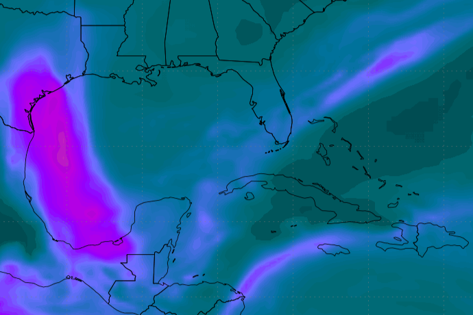
A dense plume of Saharan dust is expected to approach Texas, upper-left, from the Gulf of Mexico by Monday, according to NASA forecast data.
Goddard Earth Observing System/NASA/WeatherBELL
Monday and beyond
Forecasters are watching out for a couple of developments beginning Sunday and evolving into early next week: more Saharan dust in Southeast Texas and a shift in the high pressure system that’s been the dominant influence on Houston weather.
Article continues below this ad
“A fairly substantial Saharan Air Layer plume will filter into the area Sunday-Tuesday, with the main impact being increasingly hazy skies,” the weather service said in its bulletin.
“Finally, heading into the middle of next week, the eastern U.S. ridge will lift slightly north and increased moisture will filter into the area on its southern flank, with mentionable rain chances returning to the forecast on Wednesday,” forecasters added.
Houston on Monday and Tuesday is expected to be sunny with air temperatures on both days hitting 95 degrees. Heat index values, however, will reach 105 — only a few degrees shy of triggering a heat advisory from the weather service.
Article continues below this ad
“So even though we will likely stay just below heat advisory criteria, precautions should still be taken to avoid heat illness, particularly for strenuous activities in direct sunlight,” forecasters said.