
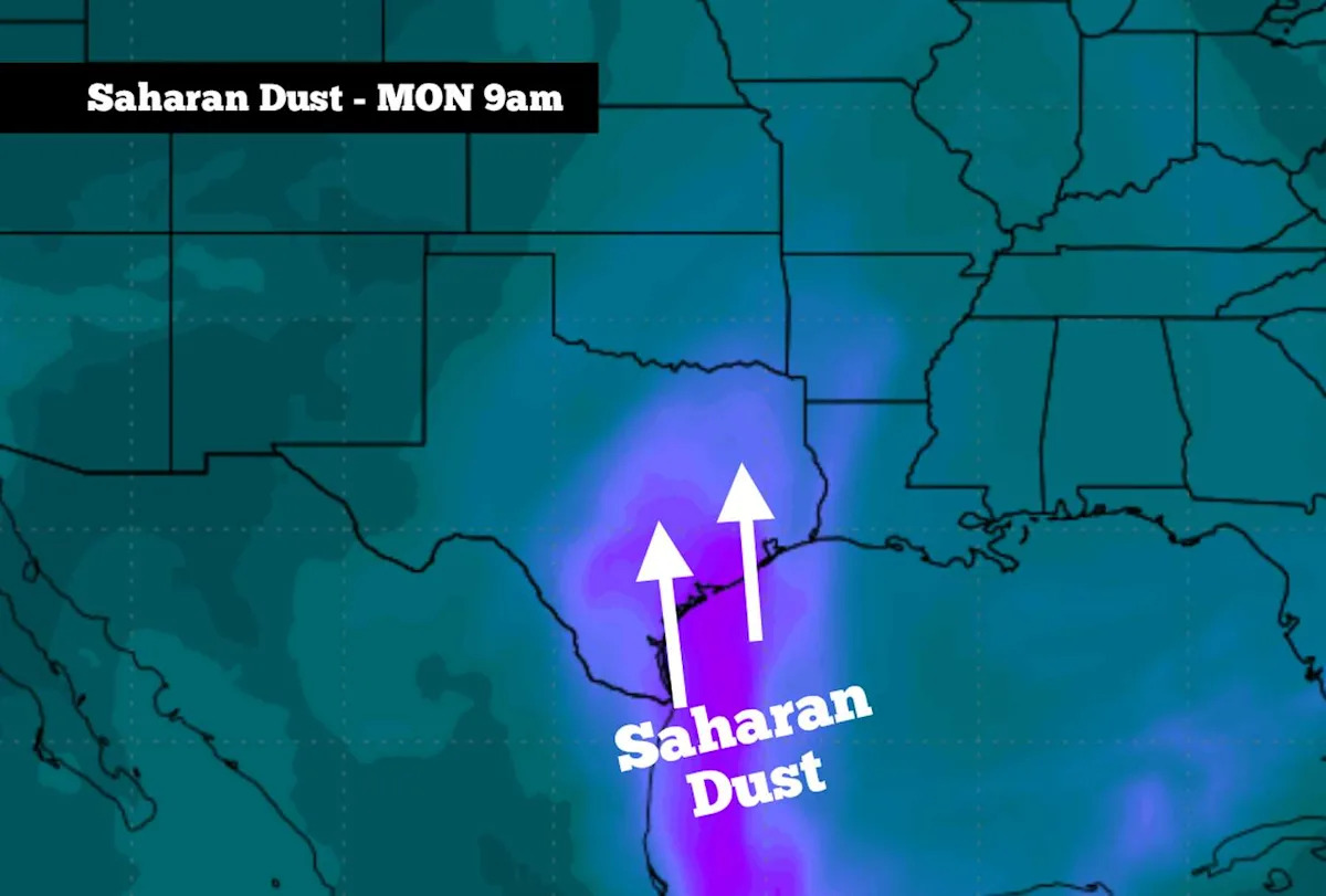
A plume of moderate to dense Saharan Dust has moved into the western Gulf, and it’s expected to continue northwest into South Texas over the next 24 to 36 hours.
This dust, which has traveled more than 4,000 miles from the African continent, is likely to create hazy conditions starting Sunday night, likely lasting through much of the day on Monday.
At the same, high pressure is also developing near Texas, which will result in persistent near to above-average heat throughout the week, before some isolated rain chances arrive by week’s end. Here’s an overview of what to expect throughout South-Central Texas.
Sunday’s forecast
Before the Saharan dust arrives, Sunday will be another hot and muggy day across the region. The morning will start with temperatures hovering in the upper 70s between 6 and 9 a.m, under partly to mostly cloudy skies.
After 9 a.m., temperatures will quickly heat up, reaching near the 90-degree mark by noon. Afternoon high temperatures near 94 degrees are expected in San Antonio, but when you factor in the humidity, the “feels like” temperature is expected to be near 102 degrees.
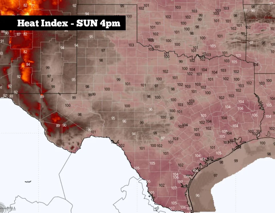
Shown are the expected heat index values across Texas at 4 p.m. Sunday afternoon. (WeatherBell)
Temperatures will be even hotter as you push to the west. Areas along the Rio Grade, including Del Rio, Eagle Pass, and Laredo, will experience high temperatures near 100 degrees with heat index values at 105 degrees or higher.
Wind speeds will be quite breezy through the afternoon and evening, moving in from the south-southeast at 15-20 mph. Evening wind gusts are likely to reach 30 mph or higher after 7 p.m., which will work to bring Saharan dust into the state.
Saharan dust arrives
Light levels of Saharan dust will move into South Texas Sunday evening after 6 p.m.. This will result in hazy skies while also causing a more vibrant sunset as dust particles suspended in the air scatter sunlight.
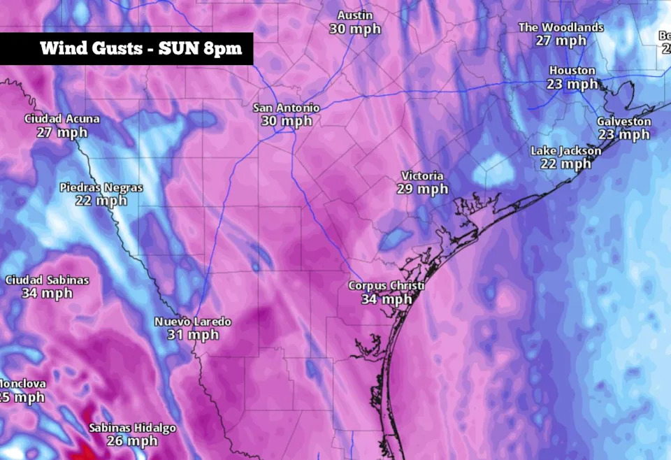
Shown are the potential wind gusts at 8 p.m. Sunday evening. (Pivotal Weather)
A more dense cloud of dust is expected to arrive overnight and into early Monday morning. This will keep skies hazy and cause worsening air quality throughout the day.
Saharan dust carries microscopic particles such as silica and quartz, which can be inhaled deeply into the lungs and trigger respiratory inflammation and irritation. It’s recommended to limit time outdoors and avoid strenuous activity outside. Saharan dust levels are expected to decrease by Monday night and into Tuesday.
The heat continues
As high atmospheric pressure continues across Texas this week, San Antonio temperatures will start remarkably consistent Monday through Thursday, with highs in the mid-90s and lows expected in the mid- to upper 70s each day. Partly cloudy skies are expected each morning, while mostly sunny skies will prevail during the afternoon.
By Thursday and Friday, a few isolated showers and weak storms may become possible. However, overall rain chances are only expected to be around 10% to 20% in the San Antonio metro area. Most will stay dry during this time.
The Fourth of July
The center of high pressure will shift closer to Texas Friday, which could cause temperatures to rise slightly for the holiday weekend. San Antonio highs temps are likely to be around 96 to 97 degrees on the Fourth of July, while many parts of North Texas will see temps rise into the triple digits.
Even though high pressure will be dominant, Gulf moisture levels will still be high, which may result in a few isolated showers and weak storms. Still, overall storm coverage is likely to be less than 20%, so most Independence Day plans should be unaffected by rainfall.
Subscribe
There’s more to San Antonio with the Express-News. Subscribe today for just 25¢.
This article originally published at Saharan dust cloud expected to hit South Texas tonight. Here’s what to expect..