
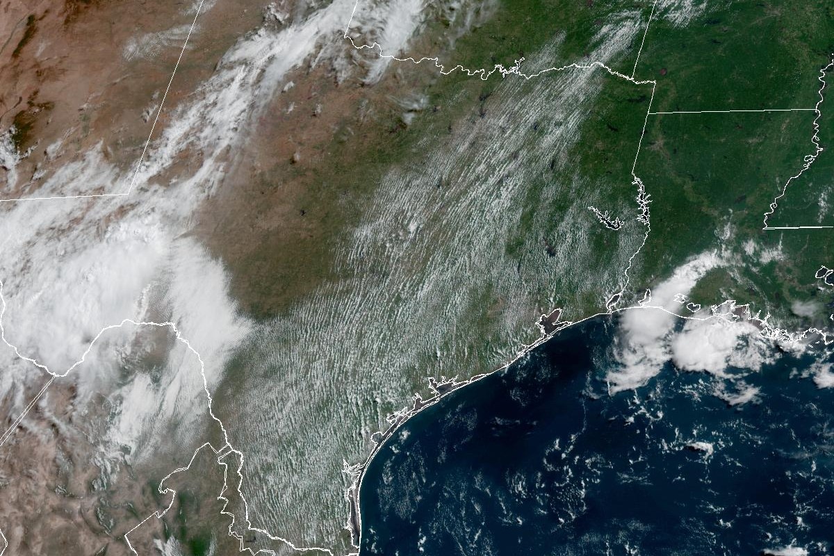
In this weather satellite photo of Texas taken around 10 a.m. Wednesday, scattered clouds dot the skies in the eastern half of Texas, while a rain-making system of low pressure hovers over the Big Bend region in far West Texas.
Geostationary Operational Environmental Satellites/CIRA and NOAA
This current stretch of hot and rain-free weather that is overlapping June and July will persist through the Fourth of July holiday, according to the National Weather Service. As we start a new month, a recap of June weather in Houston shows that the month defied expectations in some ways, but what can we expect in July?
Taking a quick look at June weather data, a few trends emerge:
June had zero days of 100-degree weather. Sure, the humidity made air temperatures feel about 10 degrees hotter than they actually were, but Houston air temperatures in 2026 at the city’s official climate observation site, Bush Intercontinental Airport, peaked at only 97 degrees on June 29.
Article continues below this ad
Milder temperatures prevailed. By averaging all the recorded daily high and low temperatures in June, you get an overall average daily temperature of 83.7 degrees. That’s only 0.7 degree higher than normal but also a full degree cooler than June last year, according to weather service data. “Normal” values are based on climate averages taken from 30 years of data (1991-2020).
Frequent rain events boosted rainfall. Rare summer cold fronts and even a sideswipe by Tropical Storm Arthur led to nearly 8 inches of rainfall in Houston in June. The total cumulative rainfall for June this year was 7.82 inches, or about 1.8 inches higher than normal.
Thursday forecast and this weekend
Given June’s numbers, will the relatively mild start to summer in Houston carry on into July? Let’s start with the short-term forecast.
Article continues below this ad
The weather service remains concerned about a moderate risk of heat danger Thursday and Friday, with peak heat index values, or humidity-driven “feels like” temperatures across Southeast Texas ranging between 102 and 107 degrees (or 39 to 42 degrees Celsius for our World Cup international visitors).
The heat risk increases Friday and into the Fourth of July weekend, forecasters said, adding that peak heat index values this weekend could be between 105 and 110 degrees (or 40 to 43 Celsius).
A broad ridge of high atmospheric pressure that had a strong influence on Houston weather in recent days will continue to shift northeast Thursday, allowing rain chances to return to Southeast Texas.
Article continues below this ad
The National Weather Service’s long-range forecasters at the Climate Prediction Center have released a temperature outlooks this week that projects above-average temperatures in Texas in the first half of July.
Climate Prediction Center/National Weather Service
Houston on Thursday has a 40% chance of afternoon showers under otherwise mostly sunny skies. Although daytime temperatures will peak at 93 degrees, the muggy air will feel like it’s 101 degrees. Rain chances ease to 20% at night, forecasters said.
“As the ridge relaxes on Thursday, richer moisture will move into the region along with a subtle impulse,” the weather service said in a forecast bulletin posted online Wednesday.
Forecasters said they anticipated scattered showers along the Gulf Coast and parts of the Piney Woods, along with more rain across far eastern Liberty and Chambers counties.
“Isolated to scattered showers are expected along and east of I-45 up to Madison County,” the weather service said. “Rain chances look to briefly diminish Friday and Saturday and then increase Sunday afternoon and into early next week.”
Article continues below this ad
The National Weather Service’s Climate Prediction Center is anticipating above-average rainfall in Texas during the first half of July.
Climate Prediction Center/National Weather Service
July outlook: What’s a normal July in Houston?
The weather service’s long-range forecasters at the Climate Prediction Center this week are projecting above-average rainfall and temperatures in Texas during the first half of July.
Houston, in particular, has a 35% chance of having above-normal rainfall and a 33% chance of near-normal rainfall in the first two weeks of July. What’s normal for Houston in July? On average, Houston records about 3.8 inches of rainfall in July, with about 2 inches of that in the first 15 days of the month.
Article continues below this ad
However, Houston is much more likely to be hotter than normal in July. The Climate Prediction Center is calling for a 48% chance of above-normal temperatures and a 33% chance of near-normal temps. Houston’s average daily high temperatures in July are around 95 degrees, so we could easily start seeing days with 100-degree temperatures start to show up.
Based on all reliable Houston weather records going back to the 1890s, the average date of the first 100-degree day of the year is July 19. But since 2000, as the effects of climate change have become more apparent, that average date has moved up to July 14.