
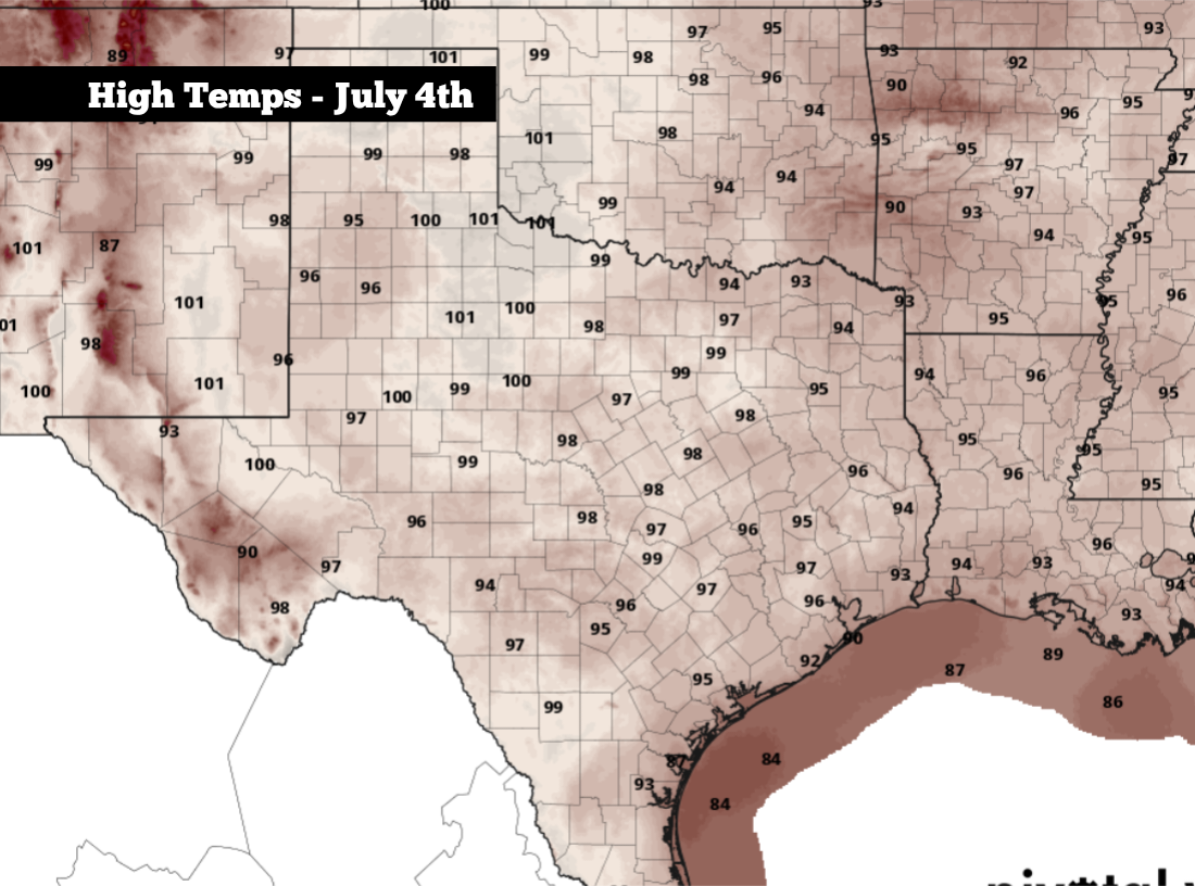
Shown are the expected high temperatures across Texas on the Fourth of July.
Pivotal Weather
Heading into the Fourth of July weekend, high-atmospheric pressure is still dominant across Texas, which will lead to hot and mostly dry weather Friday and into much of the day on Saturday.

However, by Saturday night, as firework shows are getting started across Texas, a weak upper-level disturbance may begin to form near the Rio Grande. This could trigger a few isolated showers or weak thunderstorms for parts of the state, with slightly higher rain chances expected by Sunday.
Article continues below this ad
Overall rain coverage is expected to stay sparse throughout Texas, leaving many areas dry through the Fourth of July weekend. But here’s a close look at which parts of the state have the best chance of seeing rain.
Fourth of July weekend forecast
Friday: Typical July heat is expected across Texas on Friday, with high temperatures mostly in the mid-90s. San Antonio will likely top out at around 94 degrees, while Houston and Dallas will be just slightly warmer, likely between 95 and 98 degrees. The hottest part of the state will likely be in the Panhandle, where highs could reach 100 degrees.
A few isolated storms are expected to develop, mainly across the eastern third of the state on Friday afternoon and evening.
Pivotal Weather
Most will stay dry on Friday, however a few isolated showers and storms may develop over the eastern third of the state, in areas like Houston, Lufkin, Nacogdoches, and the east side of the Dallas-Fort Worth metroplex. There, chances will be near 20%, especially between 3 and 8 p.m.
Article continues below this ad
Saturday: Temperatures won’t change much on the Fourth, but highs may rise by a degree or two across the state. San Antonio is expected to top out in the mid-90s, while the upper 90s to near 100 degrees are likely in areas like Austin, Dallas, Laredo and much of West Texas.
Rain chances will be spotty again, leaving most areas dry. However, East Texas will once again encounter a 20% chance of rain. North-Central Texas, from Dallas to Abilene, will also have a 20% chance, while parts of far West Texas may see rain chances rise to 30% during the evening. San Antonio’s rain chances will stay lower, likely less than 10%.
By 9:30 p.m., when most firework shows get going across San Antonio, temperatures will be between 86-88 degrees with south winds moving in at 10 mph.
Article continues below this ad
Sunday and Monday: Rain chances will increase slightly by the end of the holiday weekend. From late Sunday and into Monday, overall storm chances will rise to around 30% from West Texas eastward into the Hill Country, while San Antonio’s chances will rise to around 20%.
Temperatures will stay consistently hot, with highs staying in the mid-90s across south-central Texas. Humidity levels will stay elevated as well, pushing the “feels like” temp to around 100 degrees.
Article continues below this ad
No flooding expected: Throughout the weekend, storms are expected to stay very isolated, which will keep the flood threat extremely low. Storms, if any, are likely to stay quite brief, with rain lasting for 30 minutes or less. While lightning and gusty winds are possible, large hail is not expected to occur.