
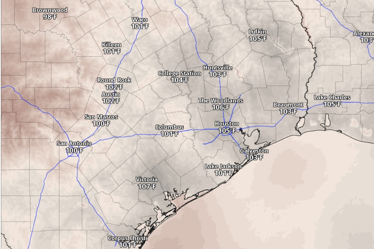
Heat index values, or humidity-driven “feels like” temperatures, in San Antonio will hit the triple digits by 3 p.m. Wednesday, according to the National Blend of Models, a composite weather forecast model.
National Blend of Models/Pivotal Weather
For nearly three weeks now, since June 20, rain gauges at San Antonio International Airport, the city’s official climate observation site, have failed to record any measurable rainfall. That means for the last 10 days of June and the first week of July, the Alamo City has been as dry as an overcooked brisket.

While the seasonable heat and humidity persist each day of the work week, we’ll have to wait for the weekend before we see more significant rain chances again, according to the National Weather Service.
Article continues below this ad
Wednesday forecast
San Antonio on Wednesday will start out partly sunny before more sunshine takes over the sky. With atmospheric moisture still firmly in place, humidity levels will push the heat index into the triple-digits, forecasters said. The city’s projected peak temperature of 95 degrees could feel more like 100, thanks to the moisture-rich air.
Nighttime won’t offer much relief from the heat, though, with balmy south-southeast winds of 5 to 10 mph, including gusts as strong as 20 mph. Overnight temperatures will stay mostly in the 80s and bottom out only around 75 degrees before sunrise Thursday.
Article continues below this ad
A mid- to upper-level ridge of high atmospheric pressure extends from northwestern Mexico to
the northern Great Plains, with a trough of low pressure from the Great Lakes to the Ark-La-Tex region.
Weather Prediction Center/National Weather Service
Texas weather is being influenced this week by a ridge of high air pressure in the middle to upper levels of the atmosphere, according to the weather service. The high pressure extends from northwestern Mexico to the northern Great Plains, while a trough of low air pressure stretches from the Great Lakes to the Arkansas-Louisiana-Texas border. The clockwise air flow around the high pressure has kept rain chances to a minimum, forecasters said.
Thursday and Friday forecast
“The upper ridge will strengthen further Thursday, keeping the weather hot and dry,” the weather service said in a forecast bulletin posted Tuesday. “Temperatures will stay fairly steady.”
Article continues below this ad
Weather in San Antonio on Thursday and Friday won’t be much different from Wednesday, according to forecasters. Thursday and Friday are shaping up to be sunny with gusty south-southeast winds continuing to feed moisture-rich air into South Texas. Expect daytime temperatures on each day to reach the mid-90s, while overnight temperatures should stay above 76 degrees.
Rain chances this weekend
“Friday, another upper trough (of low pressure) will ride over the ridge into the middle of the country and will weaken the ridge over Texas,” the weather service said. “This weakening of the ridge will coincide with a surge of moisture from the Gulf.”
Article continues below this ad
As a result, forecasters said, they expect rain chances as early as Friday afternoon and continuing through Monday.
San Antonio on Saturday has a 40% chance of afternoon showers under partly sunny skies. The prospect of rain-cooled air also means slightly lower projections for the heat: Temperatures could stay below 92 degrees on Saturday.
Article continues below this ad
At night, rain chances diminish to only a 20% chance under partly cloudy skies. The lower rain chances linger into Sunday, as do the milder afternoon temperatures in the lower 90s.