
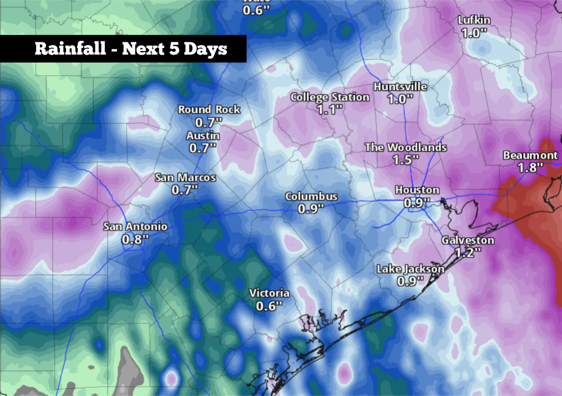
Shown are the potential rainfall totals across South Texas through Tuesday, according to the National Blend of Models. Isolated higher amounts are possible.
Pivotal Weather
After weeks of hot, quiet weather driven by high atmospheric pressure across Texas, changes are coming this weekend. A surge of Gulf moisture will move into southern portions of the state, increasing the potential for slow-moving tropical thunderstorms to arise from the Hill Country southeastward into San Antonio and along the Texas coast.

However, it should be noted that these storms are likely to stay scattered, which will limit rainfall totals and keep the flood threat quite low. While some areas may miss out on rain entirely, others across South Texas could experience tropical downpours, gusty winds and frequent lightning. Here’s when rain chances will be highest.
Article continues below this ad
Friday’s forecast
San Antonio temperatures will be similar to the past several days, with morning temps in the mid- to upper 70s, rising into the mid-80s by 11 a.m under partly cloudy skies.
Weather satellite imagery taken at 2:30 p.m. Thursday shows a disturbance in the western Gulf of Mexico as it starts to approach the Texas coastline, upper left.
NOAA
At the same time, a plume of tropical moisture is expected to move ashore along the central Texas coast, especially between Rockport and Galveston. A few showers and storms may also move near the San Antonio area between 9 a.m. and noon, but overall rain chances through the morning will generally stay under 20%.
Article continues below this ad
Later in the day, San Antonio rain chances will rise slightly, with about a 20% to 30% chance of thunderstorms during the afternoon and early evening. A few tropical downpours are possible, but most areas will not pick up significant rainfall.
Temperatures will stay warm, but afternoon highs are likely to be a few degrees cooler than the past few days because of increased cloudiness. Expect temps to top out between 91 and 93 degrees, but with “feels like” temperatures near 100 degrees as humidity levels rise.
Shown are the expected heat index values, or humidity-driven “feels like” temperatures, across South Texas for late Friday afternoon
Pivotal Weather
Increasing chances Saturday
Tropical moisture levels will keep rising on Saturday, which will allow for scattered showers and storms to increase in coverage across South-Central Texas. San Antonio’s overall rain chances will be near 40%. A few isolated tropical downpours could bring rainfall rates of 2 inches per hour or faster.
Article continues below this ad
Even with the higher rain chances, humidity-boosted heat will persist. Saturday temperatures will top out in the lower 90s, with expected heat index values likely in the triple digits.
By Sunday, rain chances will decrease across the region, but a 20% chance of a lingering shower or storm is still expected. If you plan on spending time outdoors, be sure to stay hydrated, as typical summertime heat will also continue.
Rain chances continue early next week
By Monday and Tuesday of next week, high atmospheric pressure is expected to build across the middle of the country. However, the center of the high pressure will be displaced well north of Texas, allowing for tropical moisture to continue pushing into the region.
Article continues below this ad
San Antonio will see rain chances rise again to around 30% on Monday, pushing even higher to a 50% chance of storms on Tuesday. Lower temperatures will accompany the higher rain chances, as highs may stay in the upper 80s on Tuesday.
Because storms are not expected to be widespread, total rainfall over the next five days is expected to stay relatively low. According to the National Blend of Models, between a half-inch to an inch of rain is likely for the San Antonio metro area through Tuesday, with slightly higher totals expected across parts of Kendall, Medina and Bandera counties.