
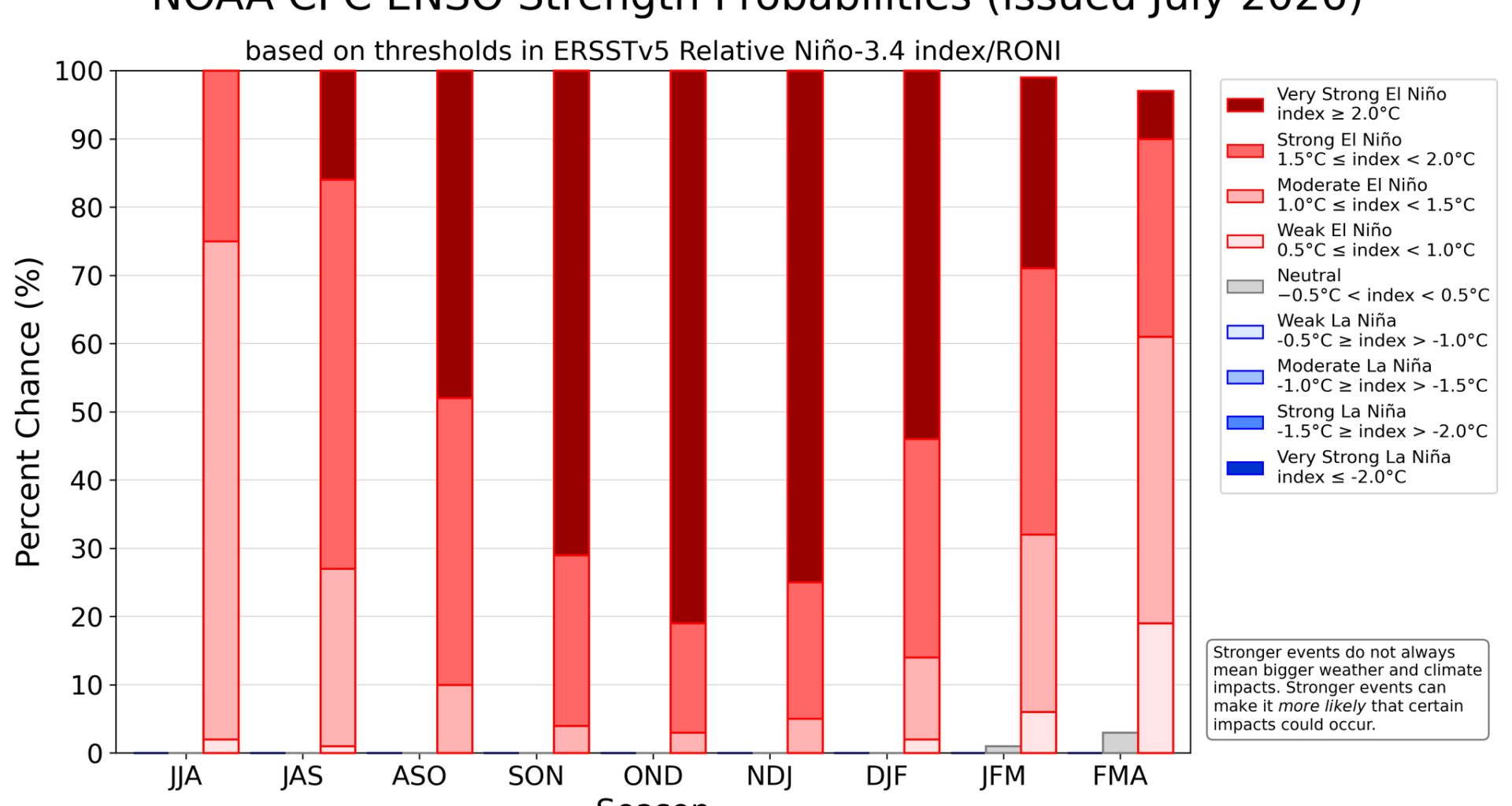
El Niño, one of the planet’s most powerful climate patterns, is rapidly gaining strength and current forecasts are giving it an 81% chance of reaching historic strength in the fall, and a 97% chance that it will continue through early spring 2027.
El Niño and its counterpart La Niña are changes in sea-surface temperatures in the world’s largest body of water, the Pacific Ocean, that can influence weather around the world. El Niño, when the equatorial waters of the eastern Pacific become warmer than normal, typically brings cooler, wetter weather into Texas, while the cooler waters during La Nina often lead to warmer and drier weather.
In recent weeks, El Niño has intensified much faster than forecasters expected, and some climate models now suggest this event could rank among the strongest on record since observations began in the 1950s.
The surge in ocean temperatures has given forecasters increasing confidence that a very strong El Niño event, or what some have dubbed a “super El Nino” could emerge this year. While it’s not an official NOAA term, a super El Niño refers to an exceptionally strong event, with Pacific sea-surface temperatures around 3 degrees above average.
While this information isn’t that worrisome during the summertime in Texas, it definitely raises some eyebrows when El Niño is expected to be at its strongest from the fall season through the following spring.
While El Niño is often associated with wetter weather across Texas during the fall and winter, its influence on our summer weather is much more limited. One notable exception is along the Texas Gulf Coast, where strengthening El Niño conditions typically reduce the threat of tropical storms and hurricanes.
If you’re planning a trip to South Padre Island or anywhere along the Texas coast this summer, the odds currently favor quieter tropical weather. A strengthening El Niño creates stronger upper-level winds across the Atlantic, producing wind shear that makes it more difficult for tropical systems to organize and intensify.
Add in repeated plumes of Saharan dust, accompanied by dry air, moving across the Atlantic, and the environment becomes even less favorable for tropical cyclone development in the weeks ahead.
The warming phase of the El Niño-Southern Oscillation officially developed in early June, marking a transition away from La Niña, which had been a recurring part of recent winters. Now, in the first half of July, a large area of the central and eastern equatorial Pacific Ocean has seen sea-surface temperatures climb to more than 1.5 degrees Celsius above the long-term average — and temperatures are expected to rise even more.
“Even the strongest El Nino events do not lead to the typical impact everywhere, but stronger events can more significantly tilt the odds in favor of expected outcomes,” climatologists from the Climate Prediction Center wrote in their monthly discussion.