
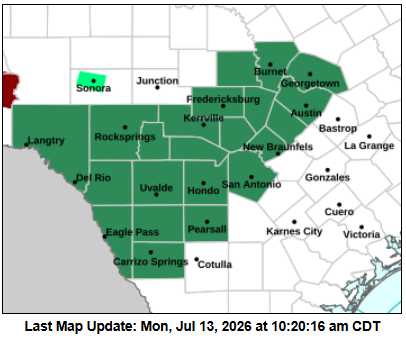
Scattered showers and thunderstorms developed across parts of Central Texas over the weekend, but that was only a preview of what’s to come. Rain chances will ramp up significantly this week as tropical moisture interacts with a slow-moving upper-level atmospheric disturbance and old outflow boundaries, setting the stage for multiple rounds of showers and thunderstorms across the Lone Star State.
With the potential for extended periods of heavy rainfall, meteorologists at the regional National Weather Service office for Austin and San Antonio have issued a flood watch beginning Monday night and lasting into Thursday evening for areas along and west of the Interstate 35 corridor. Some areas could see repeated rounds of rain, increasing the risk of flash flooding, especially in low-lying and flood-prone locations.
Rainfall totals are expected to range from 2 to 6 inches, with isolated pockets potentially reaching up to 8 inches. The highest rainfall chances will be across the western Hill Country and areas along and east of I-35.
Because the soil is already saturated from the weekend rain in some spots, high rainfall rates could quickly trigger isolated flash flooding, especially in urban and low-lying areas. The region is under a level 2 out of 4 risk, or at least a 15% chance, for flooding rainfall, meaning scattered instances of flash flooding are possible through the next several days.
Along with heavy rainfall and the potential for cloud-to-ground lightning, winds will be gusty, with speeds reaching 30 to 50 mph.
Storms will develop over the next few hours, beginning as isolated cells around noon and then becoming more scattered throughout the afternoon and more numerous this evening.
This will be the first day of storms this week with more on Tuesday through Thursday.
Remember, if you’re driving, never attempt to cross a flooded roadway. “Turn around, don’t drown” is the rule. Just a few inches of moving water can stall a vehicle or sweep it away, and it’s often impossible to judge road depth from the surface.
If heavy rainfall is occurring or flooding is possible, move to higher ground early rather than waiting for conditions to worsen. Avoid low water crossings, creeks, underpasses, and areas that are prone to pooling water.