
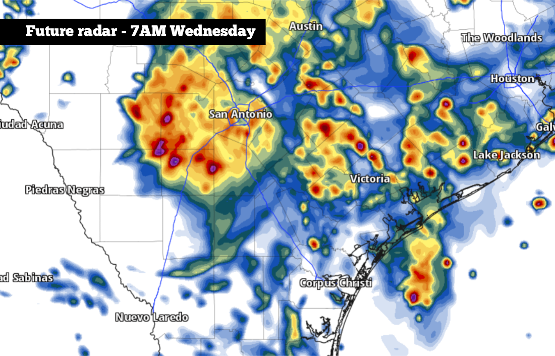
This future radar model for 7 a.m. Wednesday shows widespread showers and storms across the San Antonio area, where new flooding could occur.
Pivotal Weather
In an especially soggy morning across South-Central Texas, about 1.2 inches of rainfall have been recorded at San Antonio International Airport, the city’s official weather observation site, through 9 a.m. Tuesday. Slightly higher rainfall totals, up to 2 inches, have also been recorded on the west side of Bexar County.

However, areas to the west have experienced the brunt of the flooding rainfall. In The Hill Country, Kerrville has recorded 4.6 inches of rain since Monday, which caused flooding throughout the city.
Article continues below this ad
The worst flooding is ongoing Tuesday morning across parts of Uvalde and western Medina counties, where pockets of 6 to 12 inches of rain have fallen in the region just northeast of Uvalde and eastward to Knippa and Sabinal.
Pockets of 6 to 12 inches of rainfall have already been reported across parts of Uvalde, Medina, and Bandera counties, where flash flooding is ongoing Tuesday.
NWS Austin/San Antonio
A flash flood warning is in place for this area through at least 11 a.m., which includes Uvalde, Sabinal, D’Hanis, Hondo, and Garner State Park. Heavy rainfall, with rainfall rates of up to 4 inches per hour, continues to hit this area early Tuesday. Travel is highly discouraged.
More rain is expected across South Texas throughout the day on Tuesday and continuing into Wednesday as well. Much of the region, including San Antonio, the Hill Country and Edwards Plateau, has been upgraded to a level 3 of 4 risk, or at least a 40% chance, of excessive rainfall, a rarity for the region during mid-July. The National Weather Service also has a flood watch in place for the region through Thursday.
Article continues below this ad
Texas counties along and west of Interstate 35, including parts of the Hill Country, are under a flood watch through Thursday evening.
NWS Austin/San Antonio
San Antonio flooding timeline
Midday to midday (9 a.m. to 1 p.m.): Pockets of light rainfall are expected across much of Bexar County throughout the morning, with much of the area picking up another quarter-inch of rainfall.
With a saturated ground, this may lead to minor flooding along city streets. If you have to travel, do so with extreme caution, and do not drive over flooded roadways.
Article continues below this ad
Tuesday afternoon (1 p.m. to 6 p.m.): Rainfall is expected to become a more scattered, providing an occasional break from the wet weather. However, some scattered storms are expected to redevelop by the late afternoon, which may cause periods of brief, heavy rainfall.
Tuesday night (6 p.m. to 11 p.m): Scattered, off-and-on showers and storms are expected to continue through Tuesday night. Much of the rain will be light, but a few pockets of heavier rainfall are also possible, which could cause more flooding.
Shown are the potential cumulative rainfall totals across South Texas through Thursday, according to the National Blend of Models.
Pivotal Weather
Overnight and early Wednesday (11 p.m. to 11 a.m.): Another round of heavy rainfall is expected to develop across the region, especially from San Antonio westward to Hondo, Uvalde and Pearsall. Areas to the north, including the Hill Country and Interstate 35 corridor, may also see flooding rainfall.
Article continues below this ad
Another 2 to 5 inches of rain will be likely at this time, with isolated rainfall pockets of greater than 10 inches of rain possible for some, which could cause devastating flooding. Travel is highly discouraged overnight and early Wednesday.
A break in the activity is possible Wednesday afternoon, but yet another round of scattered thunderstorms is expected again late Wednesday and into early Thursday morning. Be sure to stay with expressnews.com/weather for updates.