
A pedestrian walks along 4th Street as rain falls in downtown Austin, Tuesday, April 21, 2026.
Mikala Compton/Austin American-Statesman
A flood watch is in effect from Monday night through Thursday evening for parts of Central Texas as forecasters warn that repeated rounds of heavy rain could trigger flash flooding.

Meteorologists with the National Weather Service office serving Austin and San Antonio isssued the watch for areas along and west of the Interstate 35 corridor. Some locations could see several rounds of rain over multiple days, increasing the risk of flooding, especially in low-lying areas and places prone to flooding.
Article continues below this ad
Don’t let Tuesday’s break in the rain fool you. The atmosphere is primed and ready to reload with some of the heaviest rainfall of the week expected to arrive overnight Tuesday and on Wednesday.
Some storms may redevelop as early as 10 p.m. to midnight, then gradually build through the overnight hours. While we don’t expect widespread flooding across the Austin metro Wednesday morning, pockets of moderate to heavy rain could still impact the morning commute.
Article continues below this ad
Storms reload overnight. Expect another round of heavy rain across Central Texas through Wednesday and it make begin as early as the morning commute.
Give yourself extra time on the roads as there could be standing water and road closures. #txwx pic.twitter.com/CDcL16u36y
— Mary Wasson (@Mary_Wasson) July 14, 2026
So far this event, Central Texas has picked up less than 2 inches of rain so we can handle a little more, however, locations west of San Antonio, like Uvalde, Medina, and Bandera, have received 7 to 10 inches of rain, any additional rain could be catastrophic.
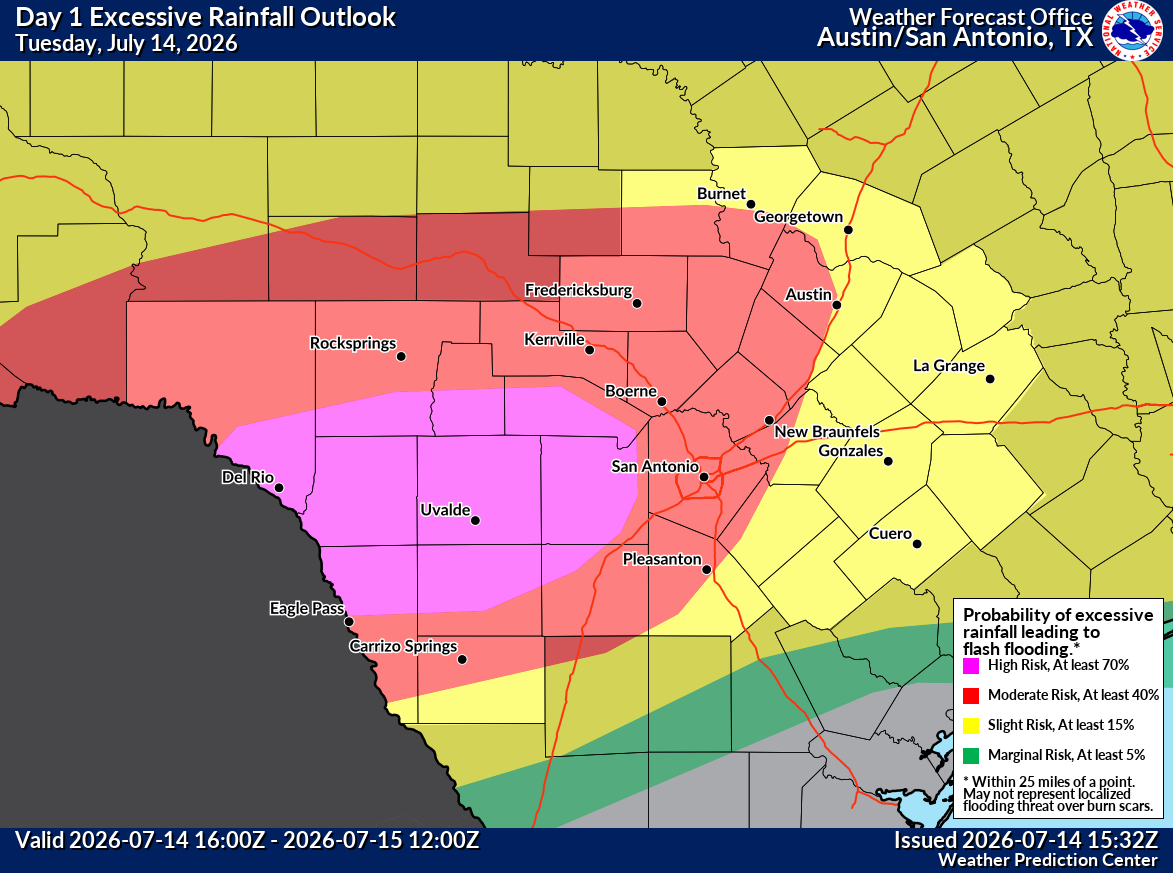
Because of the growing flood threat, the Weather Prediction Center has placed Central Texas under a level 3 of 4 excessive rainfall risk, while parts of South Texas along the U.S. 90 corridor west of San Antonio—including the southern Edwards Plateau and Rio Grande Plains—are under a rare level 4 of 4 excessive rainfall outlook.
This highest-level designation means there is more than a 70% chance that rainfall will exceed flash flood guidance, creating the potential for widespread, life-threatening flash flooding.
Article continues below this ad
Because of the growing flood threat, the Weather Prediction Center has placed Central Texas under a level 3 of 4 excessive rainfall risk, while parts of South Texas along the U.S. 90 corridor west of San Antonio—including the southern Edwards Plateau and Rio Grande Plains—are under a rare level 4 of 4 excessive rainfall outlook.
National Weather Service Austin/San Antonio
According to NOAA, a level 4 (High) Risk is issued only about 4% of the time and is reserved for the most significant flash flood events. There are a significant number of people visiting and vacationing in this area who will need to be prepared for rapidly rising water, dangerous travel conditions, and the potential for numerous flash flood warnings.
— Mary Wasson, newsroom meteorologist
After soaking parts of the Austin area overnight and through Tuesday morning, the rain is taking a brief break, but don’t let that lull fool you. Another round of heavy showers and thunderstorms is expected to develop late tonight and continue into Wednesday, bringing a renewed threat of flooding across Central Texas.
Article continues below this ad
Several flood advisories have already been issued for parts of the region, and additional flood alerts may be needed as the next wave of heavy rain moves in. With saturated ground in some locations and multiple rounds of rain still in the forecast, the risk of flash flooding will remain elevated through midweek.
Rainfall over the past 24 hours has ranged from 0.10″ to 1.50″ across the Austin area, but we’re not done yet.
Expect a lull this afternoon before another round of heavy rain moves in overnight and into Wednesday.
Stay weather aware. #txwx pic.twitter.com/1kFAwBQLl6
— Mary Wasson (@Mary_Wasson) July 14, 2026
So far, the highest rain totals are between 1 and 2 inches across the city.
1.52 – West Bouldin Creek
1.52 – Grover Tributary at Joe Sayers Ave.
1.44 – Waller Creek
1.39 – Onion Creek
1.19 – Manchaca
1.17 – Dripping Springs
1.08 – Williamson Creek
Article continues below this ad
Keep in mind that any rain and storms that develop will contain moderate to heavy rain with quick rain totals up to 2 inches possible.
“Along with these high values, weak wind shear will lead to slow moving and erratic storm motion that could eventually lead to training storms,” meteorologists at the Austin and San Antonio National Weather Service said.
This weather pattern will continue to increase the potential for locally heavy rainfall and flash flooding through Thursday. Widespread rainfall totals of 2 to 6 inches are expected, with isolated areas, especially southwest of Austin, could see storm totals between 10 and 20 inches.
With saturated ground in some locations and multiple rounds of rain still in the forecast, the risk of flash flooding will remain elevated through midweek.
National Weather Service Austin/San Antonio
— Mary Wasson, newsroom meteorologist
Article continues below this ad
Heavy rain is continuing to soak parts of Central and South Texas, with the most significant flooding concerns centered west of San Antonio.
While rainfall across the Austin metro was generally lighter overnight — ranging from 0.05 to 1.50 inches — communities farther west and south picked up much higher totals. Bastrop received more than 3.30 inches of rain, while nearly 4.50 inches fell near Fredericksburg. Even more impressive amounts of 2 to 7 inches fell in just six hours from Uvalde to Sabinal, triggering numerous flood warnings and dangerous flash flooding.
Heavy rain is continuing to soak parts of Central and South Texas, with the most significant flooding concerns centered west of San Antonio.
National Weather Service Austin/San Antonio
Also, a flood warning for the Medina River in Bandera is impacting the mobile home parks near the river, like Pioneer RV park and the upper end of Medina Lake.
Article continues below this ad
Flood watch is still in effect for areas along and west of Interstate-35, with the highest concern in the western Hill County, Edwards Plateau and Rio Grande. In addition, the Weather Prediction Center has upgraded the excessive rainfall outlook to a level 4 threat out west and a level 2 to 3 out of 4 threat in Central Texas with possible 10 to 20 inch rain totals in that location.
Heavy rain is continuing to soak parts of Central and South Texas, with the most significant flooding concerns centered west of San Antonio.
National Weather Service Austin/San Antonio
— Mary Wasson, newsroom meteorologist
Austin fire crews responded to 2200 Hancock Drive around 7:40 a.m. Tuesday following reports that three people had been swept away in Shoal Creek.
Article continues below this ad
According to Captain Ryan Arencibia, the Austin Fire Department received a call from someone reporting three friends were in a tunnel and she heard them scream, then was unable to locate them after the water began to rise. Fire crews and Austin-Travis County EMS searched the area and were unable to locate anyone after searching the banks and bridge crossings, as well as deploying a drone, Arencibia said.
A post on X from the Austin Fire Department showed rapidly moving water in Shoal Creek.
— Katey Psencik, breaking and trending editor, and Faith Bugenhagen, breaking and trending reporter
Article continues below this ad
Article continues below this ad