
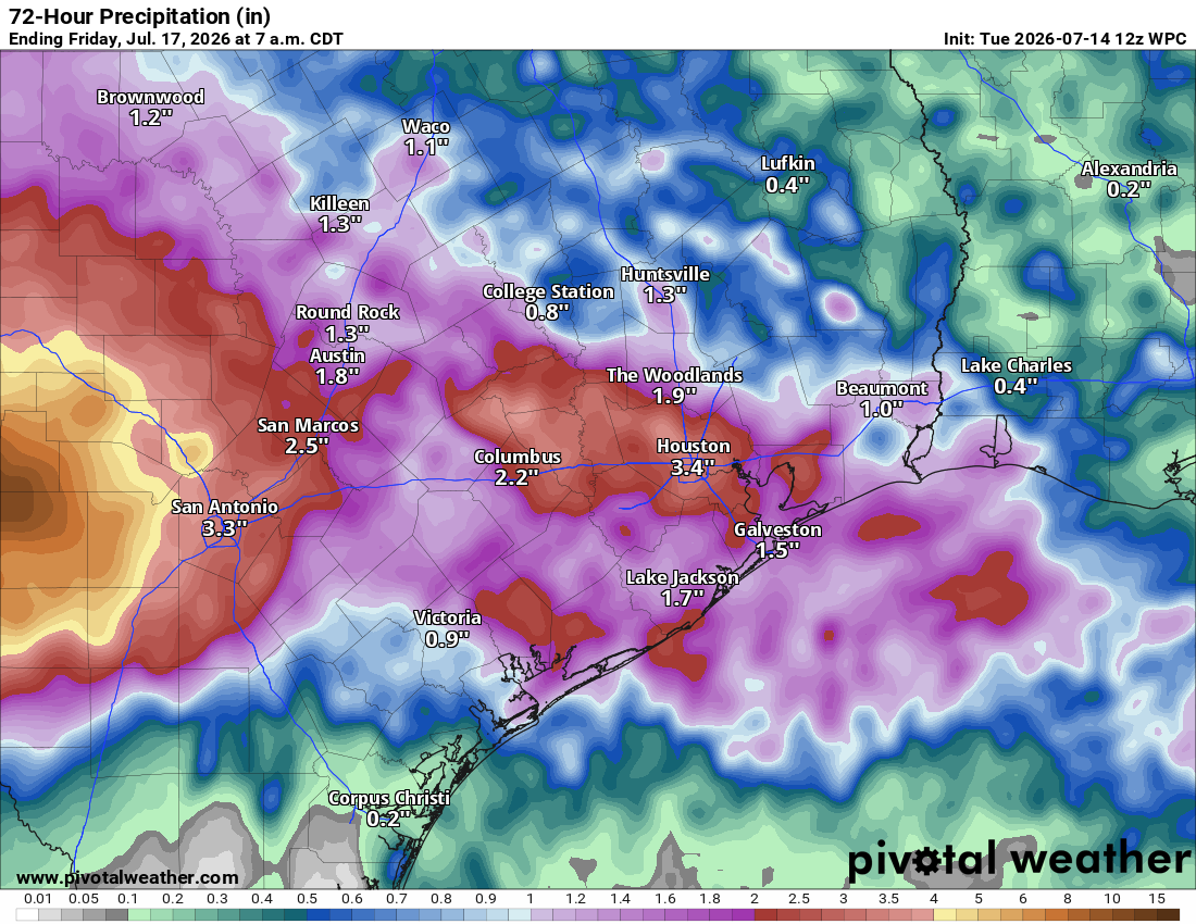
Rainfall totals between an inch and 3 inches are likely across Central Texas, with localized amounts of up to 4 inches.
Pivotal
It almost feels like Texans have stepped into an alternate weather universe. Instead of the scorching July heat that’s typical this time of year, much of the Lone Star State is seeing afternoon temperatures in the 70s and 80s along with widespread heavy rainfall and the threat of flooding.

Meanwhile, the northern Plains are enduring the kind of weather usually reserved for Texas, with relentless sunshine and oppressive heat sending temperatures in eastern Montana soaring above 112 degrees earlier this week.
Article continues below this ad
The unusual setup is being driven by a heat dome, or strong area of high air pressure, parked north of Texas from the Rocky Mountains to the Ohio Valley. Along the southern edge of the high pressure system’s clockwise air circulation, upper-level atmospheric disturbances are tracking into Texas along a stalled frontal boundary.
Combined with a steady feed of tropical moisture, this weather pattern over Central Texas is creating a recipe for heavy rainfall and potential flooding that will continue through Thursday evening while a flood watch remains in effect.
Heavy rainfall timing
Wednesday morning could be a rough one for commuters as overnight rain continues to spread across the Austin area, and storm activity potentially increases through the mid-morning.
Article continues below this ad
AUSTIN FLOODS: Follow like radar imagery with our Flood Tracker for Central Texas
The morning commute could be slowed by water pooling on streets and possible road closures, especially at low water crossings. Before heading out, be sure to check the latest travel conditions.
This high-resolution projected radar model for 8 a.m. Wednesday shows storms forming along the Interstate 10 corridor, from Central Texas to the Gulf Coast.
Pivotal
This high-resolution projected radar model for 10 a.m. Wednesday shows storms forming along the Interstate 10 corridor, from Central Texas to the Gulf Coast.
Pivotal
This high-resolution projected radar model for noon Wednesday shows storms forming along the Interstate 10 corridor, from Central Texas to the Gulf Coast.
Pivotal
This high-resolution projected radar model for 2 p.m. Wednesday shows storms forming along the Interstate 10 corridor, from Central Texas to the Gulf Coast.
Pivotal
This high-resolution projected radar model for 4 p.m. Wednesday shows storms forming along the Interstate 10 corridor, from Central Texas to the Gulf Coast.
Pivotal
This high-resolution projected radar model for 6 p.m. Wednesday shows storms forming along the Interstate 10 corridor, from Central Texas to the Gulf Coast.
Pivotal
As mentioned, rain will expand across the Interstate 35 corridor on Wednesday as another round of showers and thunderstorms develops. According to the National Weather Service, precipitable water values are already exceeding 2 inches across Central Texas. Precipitable water values are measurements that tell meteorologists how much rain could potentially fall if all water vapor overhead condensed into liquid.
Article continues below this ad
More rain is on the way Wednesday. 🌧️
Additional rainfall totals across Austin will range from 1–2 inches on the lower end to 2–3 inches in higher-end scenarios, with isolated amounts even higher. #txwx pic.twitter.com/zNObRplCzL
— Mary Wasson (@Mary_Wasson) July 14, 2026
“Along with these high values, weak wind shear will lead to slow-moving and erratic storm motion that could eventually lead to training storms,” meteorologists at the National Weather Service said in their forecast discussion for Central Texas. Training storms are storms that can cause flooding because they pass over the same location, like train cars at a railroad crossing. “This will continue to lead to increasing chances for locally heavy rainfall and possible flooding to continue into Wednesday.”
What’s the difference between a flood watch and a flood warning?
National Weather Service
With all areas in Central Texas saturated from the recent rainfall, any new amounts will become unabsorbed runoff and could cause localized flooding across Austin. Our current flood watch, which lasts until Thursday, could easily turn into a flood warning.
Article continues below this ad
The weather service’s Weather Prediction Center has placed Central Texas under levels 2 and 3 out of 4, or at least a 15% to 40% chance, of flooding rainfall occurring. Parts of the Rio Grande Valley and Edwards Plateau are under a level 4 risk, which is the highest threat level.
Rest of the week’s forecast
The wet weather pattern will continue into Thursday with another round or two of showers and thunderstorms possible. Flooding will remain a concern, especially west of Austin, where the Weather Prediction Center continues to maintain a level 1 to level 2 out of 4 risk for excessive rainfall.
Article continues below this ad
By late in the work week, the upper-level pattern will begin to shift, reducing the threat of widespread heavy rainfall. A few isolated showers and storms will still be possible Friday, but the overall rain chances will decrease significantly, and the weekend is shaping up to be much drier.
The clouds and rain will keep temperatures below normal throughout the work week, with highs staying in the 80s and low 90s. As sunshine returns this weekend, temperatures will gradually climb back toward seasonable levels in the mid-90s, with a warmer and more typical July feel returning by Sunday.