
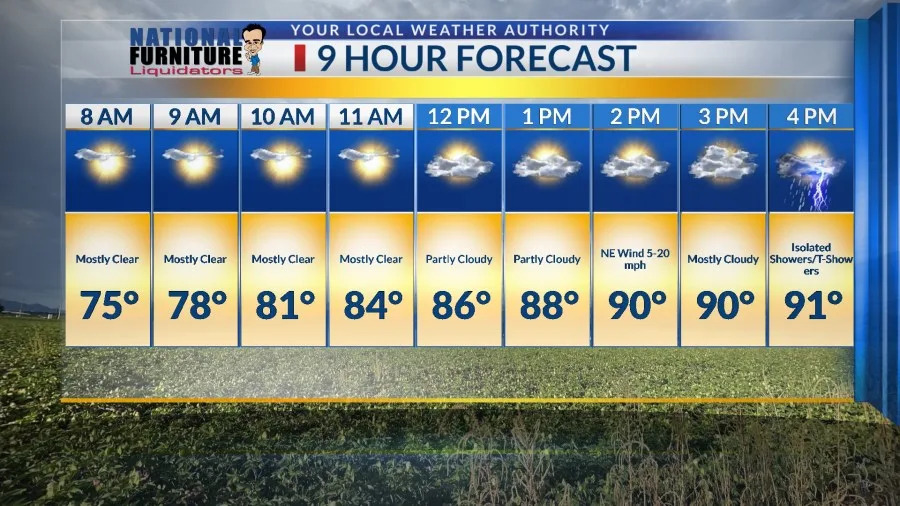
The high today was 94. Yes, the morning was quite muggy, but the humidity levels dropped for the afternoon as expected. Here’s your exclusive 9-Hour Forecast for Thursday.

TONIGHT: The skies will be partly cloudy. A cluster of t-showers that cropped up over the Sacramento Mountains and will drift SW toward El Paso and Las Cruces. At a minimum, we are likely to get gusty winds and dust as the storms break apart with a few, small, isolated showers. Mid evening, the skies will turn fair with only a few clouds as the winds die down. The low will drop to 70, and the east wind will range from 5-15 mph.
FORECAST: Thursday will be partly to mostly cloudy and 91. Isolated showers/t-showers will pop up here and there. The NE winds will range from 5-20 mph with gusts near area storm cells. Friday will be partly cloudy with scattered showers and t-showers. Friday’s high: 93. Some storms on Friday may become strong with brief, heavy rain. Saturday will be partly to mostly cloudy with widely scattered showers and t-showers. Some storms may produce heavy rainfall and cause localized flooding. Saturday’s high: 93. Sunday will be partly cloudy and 94. Though we will have a chance of isolated showers here and there, you’ll notice a transition away from high humidity to a drier pattern for the week ahead. Monday will be partly cloudy and 97 with a chance of isolated showers here and there. Tuesday will be mostly sunny and 100. Wednesday will be sunny and 100.

Copyright 2026 Nexstar Media, Inc. All rights reserved. This material may not be published, broadcast, rewritten, or redistributed.
For the latest news, weather, sports, and streaming video, head to KTSM 9 News.