
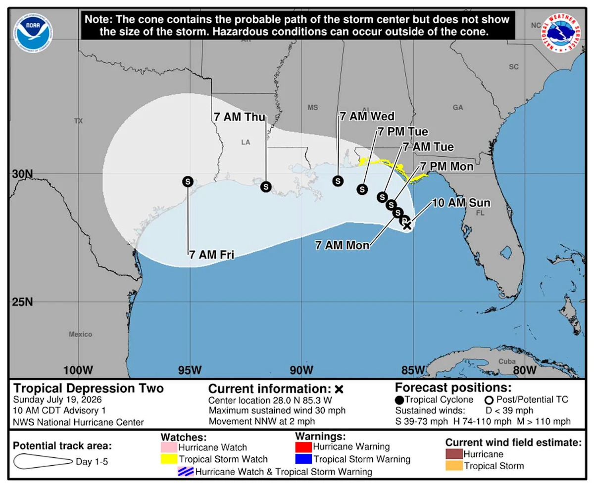
Tropical Depression Two has formed in the northeastern Gulf of Mexico, putting Texas and the western Gulf Coast in the forecast for potential impacts this week.
The National Hurricane Center upgraded the sprawling area of low pressure to Tropical Depression Two on Sunday morning after satellite imagery and surface observations confirmed it had developed a well-defined circulation.
Impacts from this system early this week will focus on Florida and the eastern Gulf Coast. But Texas has now entered the forecast picture as the depression is expected to turn west later this week.
As of 10 a.m. Sunday, the depression was centered about 155 miles south of Panama City, Fla. It had maximum sustained winds of 30 mph and was moving north-northwest at just 2 mph.
Gradual strengthening is expected, and the hurricane center forecasts that the depression will become Tropical Storm Bertha by Sunday night or Monday.
Here’s where it’s expected to track
The depression remains broad and only loosely organized, with dry air and modest wind shear – winds that change speed or direction with height – limiting development for now. Those factors should keep development gradual through the next day or so.
5 THINGS TO KNOW: Separating fact from fiction about El Niño.
A tropical storm watch has been issued for portions of the Florida Panhandle, where tropical storm conditions could develop by late Monday.
The larger-scale weather pattern should keep the depression drifting northwest through Monday before high pressure builds across the southern United States and steers it west or west-northwest. That would carry the system near or along the northern Gulf Coast through the middle and latter part of the week.

Tropical Depression Two is visible on satellite as it churns off the Florida Gulf Coast late Sunday morning. As the system moves gradually northwest this week, it’s expected to bring heavy rain, gusty winds, and rough surf along the Gulf Coast. (National Oceanic and Atmospheric Administration)
Additional strengthening will depend largely on how much time the center spends over the warm Gulf waters after nearing the Florida Panhandle. More interaction with land would tend to limit development.
Air Force Hurricane Hunters are scheduled to investigate the depression later Sunday. Those observations should provide a clearer picture of the storm’s structure and help refine future forecasts.
Could Tropical Depression Two impact Texas? What to know
No tropical watches or warnings are in effect for Texas. Texas isn’t expected to experience impacts during the next couple of days.
Even so, the hurricane center specifically identifies Texas among the Gulf Coast states that should monitor the system. Additional watches could be needed farther west during the next day or two if the current forecast holds.
HOUSTON WEATHER:
Never miss a tropical forecast update from Houston Chronicle meteorologist Justin Ballard.
It’s still too early to determine exactly what impacts, if any, Texas could experience. The biggest questions are how quickly the system turns west, how close it tracks to the coastline and how much time it remains over water after approaching the Florida Panhandle.
After last week’s rounds of heavy rain, flooding will be one of the biggest concerns for many Texans. Whether flooding becomes a concern in Texas will depend on the storm’s eventual track, as rainfall amounts and the location of the heaviest bands remain highly uncertain.
Even if the center ultimately stays east of Texas, tropical systems moving along the northern Gulf Coast can spread periods of heavy rain, gusty winds, rough surf and elevated tides well away from where they make landfall.

This map shows the potential paths Tropical Depression Two could take this week. It likely would not reach the western Gulf Coast until after Wednesday. (WeatherBELL)
For now, the greatest impacts are expected farther east. The depression is forecast to produce 2 to 4 inches of rain, with locally up to 8 inches, from western Florida through southern Alabama, Mississippi and Louisiana through Thursday. Flash flooding will be possible, especially in urban areas.
The next 24 to 48 hours will be critical in determining whether the system remains primarily an eastern Gulf Coast concern or becomes a more significant threat to the western Gulf.
While no preparations are necessary specifically for Tropical Depression Two at this point, the next couple of dry days offer a good opportunity to take care of routine hurricane-season tasks. Clearing storm drains, making sure you have multiple ways to receive weather alerts and reviewing your emergency plan are all easier to do now than if Texas eventually comes under a tropical watch or warning later this week.
Subscribe
There’s more to Houston with the Chronicle. Subscribe today for just 25¢.
This article originally published at Tropical Depression Two forms in Gulf, putting Texas in forecast later this week.