
After a wild week of historic rainfall and flooding, Central Texas is finally returning to our regularly scheduled summer programing.
High air pressure is now settling in across the region, bringing back plenty of sunshine, drier weather and temperatures climbing into the 90s.
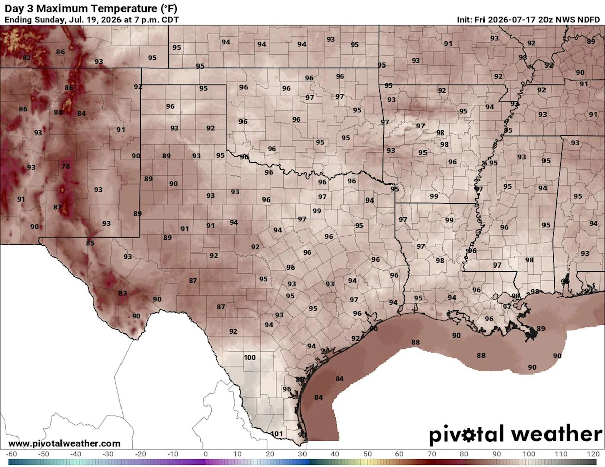
Sunday will start with mostly cloudy skies and temperatures in the mid-70s. Clouds will gradually clear by midday, allowing temperatures to climb into the upper 80s and then the lower to mid-90s by the afternoon. Humidity will remain high, as indicated by moisture-driven dew point temperatures in the 70s, thanks to the recent rainfall and moisture evaporating from the saturated ground. Heat index values, or “feels like” temperatures, will range from 100 to 103 degrees.

Temperatures will be closer to July’s seasonal averages. (Pivotal)
This type of weather will continue throughout most of the week as a broad area of high atmospheric pressure, called the subtropical high or subtropical ridge, settles over the southwestern United States, and including over Texas.
SUMMER HEAT: The heat dome is here. What does that mean for Texas and summer temperatures?
You might also hear this referred to as a summer heat dome, which is a large area of high pressure that acts like the lid on a pot, trapping heat near the ground. Within a system of high pressure, air sinks rather than rises and that sinking air suppresses the formation of towering rain clouds, leading to mostly sunny skies and allowing temperatures to climb day after day.

High air pressure will be our dominating weather feature next week across the Lone Star State. This is the forecast for the upper-levels of the atmosphere on Wednesday. (WeatherBell)
This is what we’ll experience this week across Central Texas. Temperatures will steadily rise into the middle and upper 90s with sunshine each day.
What’s happening across the country?
While we’ve been in our flooding bubble this past week here in Texas, other parts of the country have been experiencing major weather-related issues.

The Lincoln Memorial, the Washington Monument, and the U.S. Capitol, are barely visible from an overlook in Arlington, Va., as heavy smoke from Canadian wildfires shrouds the landscape in Washington, D.C., on Friday. (J. Scott Applewhite/Associated Press)
Wildfire smoke: Millions of people across the Midwest and Northeast will be experiencing unhealthy air quality this weekend because of the smoke from more than 800 wildfires burning across Canada.
A dome of high pressure parked over the Great Lakes and Northeast has trapped the smoke near the ground, while winds continue to carry it throughout the region.

Showers and thunderstorms over the eastern Gulf of America are associated with an upper-level low air pressure system and a surface trough of low pressure. (National Hurricane Center)
Atlantic tropical activity: After a slow start to the Atlantic hurricane season, we’re finally beginning to see a few areas that the National Hurricane Center is monitoring.
The National Hurricane Center is watching an area of low air pressure in the northern Gulf of Mexico near Florida, where thunderstorms are occurring. Forecasters warned that “some gradual development of this system is possible while it moves slowly northward or north-northwestward during the next few days.”
“Interests along the Florida west coast and Florida Panhandle should monitor the progress of this system as it is expected to bring heavy rain to portions of that region during the next several days,” the hurricane center said. Forecasters gave the system only a 30% chance of developing into a tropical cyclone over the next seven days.

The low pressure system near Florida will produce several days of rainfall, with the highest totals concentrated on the western coast of the peninsula through Thursday. (Pivotal)
If the system does strengthen into a tropical storm, it would earn the name Bertha, which is assigned to the second named storm in this year’s Atlantic hurricane season.
This article originally published at Heat returns to Texas on Sunday while wildfire smoke plagues other parts of the nation.